Banjarbaru _ Framing the Adhesive Green Armature: A Graduate Project

Background and Objective
Banjar Bakula is the strategic region of South Kalimantan, Indonesia composed of Banjarmasin, Banjarbaru, and parts of Banjar regency and Barito Kuala. Among these regions, Banjarmasin is known to be a “River City” because of its proximity to the Barito River and Martapura River. Banjarbaru is the new administrative center of the South Kalimantan Province. Water has a close relation with this region considering ecological, transportation, production, spatial and social aspects. Presence of Trishakti deep-water port and Syamsudin Noor Airport is an important catalyst for the economic development of this region in both local and global context. Like many other Asian cities, the post-colonial development in Banjar Bakula focuses on road based urbanization. Cities are growing rapidly with road based infrastructural development, where water ways are neglected. Though the contemporary urban development is far away from its water based origins, it serves the region and the inhabitants. From the fieldwork (February, 2015) it is merely visible that the territory had various Landscape reasoning as a basis, from which it has been evolved.
[Click on the image for a larger view]

Concept and Consideration
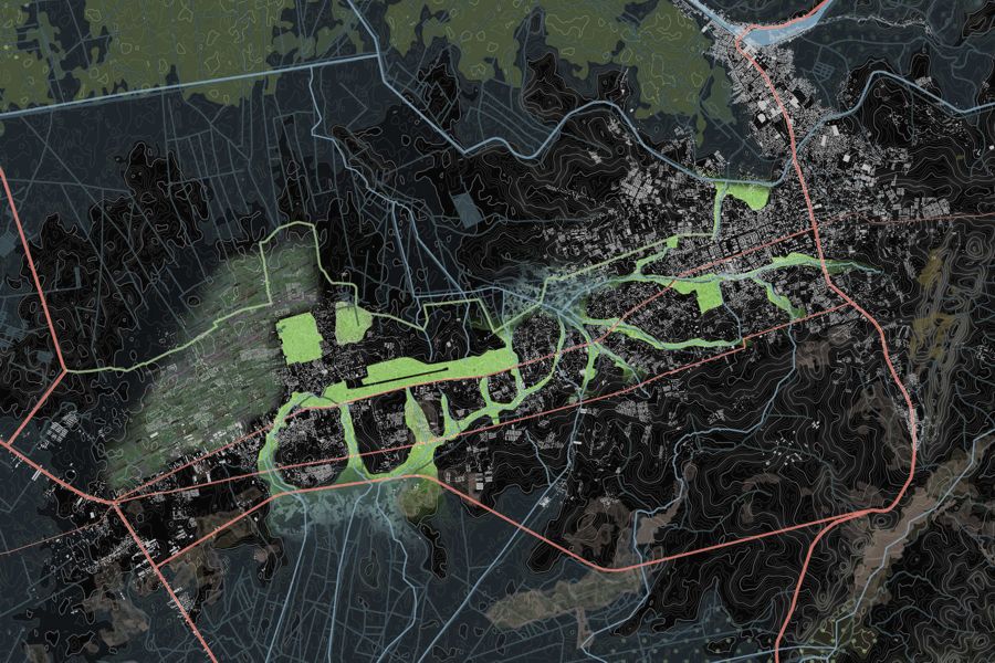
FRAMING AN ADHESIVE GREEN ARMATURE_ Coherence, density and porosity: preserving space for water while forming a collective space
Developed on the foothills, the city of Banjarbaru is located in highlands and good soil conditions, on a hilly island surrounded by wetlands. The city has the capacity and the potential to accommodate a doubling in population and is about to face a rapid shift in scale as the new urban block is the cluster, a homogeneous patch of new housing. The lack of structure of the dispersed development is resulting in lack of identity; a fragmented settlement is expanding, lacking in connectivity and without public space. The emerging patchwork is producing a fragmented and dispersed urbanity that shows no concern or respect for the ecological corridors. The developed drainage system is resulting in a dry city, where flooding forms an exception and is mostly accidental. However, the existing green flows inside the city of Banjarbaru are currently part of this fragmented dispersion, or being suppressed from the expanding urban tissue. The hidden potential of these flows is crucial for the existing and emerging city, as they can constitute the new adhesive public spaces of porosity in a dense structure. They form the ecological corridors and work together with the drainage system, while at the same time, connecting with the waterscape. The main guideline for these flows is the hilly topography of the area that creates a complex terrain of ridges and valleys which is imprinted in the contemporary city.
[Click on the image for a larger view]

The urban growth of Banjarbaru is related to the high land and low land, as the new urbanization areas in the area are primarily occupying the high land as the suitable space for urban development. In the frame of a more dense and compact city, associated to public space and infrastructure, the (re)interpretation of the inner and outer edge between city and green areas is essential as a strategy to guide the spontaneous fragmented infill of the landscape, protecting the water and green structure and leading the future urbanization process in congruence with the ecological processes.
[Click on the image for a larger view]

Design Brief
A concentration of amenities along Ahmad Yani road defines the current civic spine of Banjarbaru. While the upcoming regional road forms a bypass for the city, Trikora road constitutes a collector of new amenities that along with A.Yani form a double civic spine. In this regard the potential of the existing could be articulated with new attractors and new programs as supporting elements of the ecological dynamics of the city.
[Click on the image for a larger view]

The public space is the structure for the emerging city, a network of public parks act as an inner urban-rural interface and as a part of an ecological system that contributes to the natural water purification process and low land reservoirs for water. Upgrading the existing tissue with new mixed typologies, integrating housing and agriculture, high density with open spaces and nature forms the strategy to connect the landscape through the city, address the issue of the fragmented dispersion while protecting the agricultural landscape.
[Click on the image for a larger view]

This ecological system of collective spaces in the city forms the adhesive green armature that strengthens three different urbanities, providing at the same time a grid that directs the growth in different ways; the AGRO_CITY, the AIRPORT_CITY and the ADMINISTRATIVE_CITY. The green armature is integrating urban agro-pockets with a series of green boulevards and a network of linear transversal parks. The green lines are interconnecting elements of multiple urban scales while stimulating high density around. The existing mosque is gaining high importance as it’s the catalyst of the emerging urbanization. The densification process through the adhesive green armature is a strategy to strengthen the sense of urbanity in the context of each identity. The public space that concentrates collective services is a device for directing the future urbanization process in Banjarbaru, as it structures a civic meaning for the void, addressing compactness and permeability
[Click on the image for a larger view]


