| Notes from the Architect |
During the Liberation War of 1971, Feni was one of the most crucial war zones because of its geographical location. Feni Government College field was used as a mass slaughtering ground by the Pakistani invaders. Martyrs were inhumanly tortured, murdered and buried beneath the college field. Families were rushed to the college grounds as soon as Feni was independent on December 6th, in the hope of finding their loved ones.


Even after 52 years of independence, the people of Feni weeps recalling the horrors the martyrs endured during the war. Students of Feni Government College boldly portrayed the terrors of the war in a school play called “Goalpost”. They reminded the audience how their present college was converted into a torture cell by the Pakistani raiders in 1971. The Muktibahini and their supporters were brutally tortured and killed by gunshot while hanged by cords on the goalpost of the college field; later thrown in the pond or buried below the college ground.


The government authority of Feni was moved by the performance of the students. They were motivated to revitalize the abandoned space in honor of the martyrs of Feni. The architects of the project took inspiration from the cruel history of “goalpost” and initiated the idea of an abstract monumental goalpost – symbolizing the horrific incident of hanged martyrs. The concept was to revive the memory of the martyrs so that young students could understand and appreciate the sacrifices that were made in 1971.
“এক সাগর রক্তের বিনিময়ে, বাংলার স্বাধীনতা আনলে যারা, আমরা তোমাদের ভুলবো না”
(“We will not forget you, who brought the freedom of Bangla, in exchange of an ocean of blood “)
This renowned quote was written on the right side of the façade of the monument, reflecting the concept of the project.


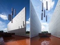
The goal was to curate a lively space where people can gather and feel connected to our history and interrelate. The enormous height of the monument can be seen from a long distance, calling out to people from afar. People all around the space are drawn to explore the outstanding landscape. The pavement of the structure is linked with the school courtyard. Moreover, it is easily accessible from the pathway beside the pond. Walking down the pedestrian, one can feel the vastness of the structure – two 40’ tall walls, representing the infamous football post. On the left side of the concrete façade –
“মুক্তির মন্দির সোপানতলে কত প্রাণ হল বলিদান, লেখা আছে অশ্রুজলে”
(“On the steps of the temple of liberation, how many lives were sacrificed, it is written in tears”) written in Bangla golden font. The 40’ black wall on the back carries round blood-red punches, symbolizing the gunshots our martyrs had to endure. Sixteen lit steps till one stands on the monumental plaza, and looking up from there – six copper cylinders suspended by cords, which represent the journey of our immortal warriors of Feni. Each cylinder signifies different stages of the war –
চেতনা (Cognition); জাগরণ (Awakening); সংগ্রাম (Warfare); বেদনা (Agony); জয় (Victory); স্বাধীনতা (Independence).


Immediately following the launch, schoolchildren performed in the amphitheater, and members of the public gathered to pay tribute to the martyrs. While walking around, visitors learn about Feni independence by reading the four memorial plaques. They read about the history and stories of the sacrifices of our martyrs, names of 31 Bir Muktijoddha (Freedom Fighters), and later find themselves standing in front of our nation’s map and flag. People learned about stories of a man who came to Feni College slaughter-ground in 1972, in search of his brother. He picked up a skull from the piles of bones, holding it close to his heart. When asked why he is taking it, he said – “Pakistani invaders took my brother to the Feni College Camp and he has been missing ever since. My brother had a larger head, and this skull looks bigger than the others.” These shattering tales remind the youths about the sacrifices of their roots.


The once-abandoned area has become a ceremonial place to socialize and commemorate the history of Feni College Boddhobhumi.
Architectural Firm: Vector Plinth
Lead Architect: Muhammad Jabed Iqbal Rupam & Mohammad Faisal Sabri
Design Team: Md Jahirul Islam, Sabrina Lipy, Jahid Hossain
Structural & Plumbing Engineer: Pratim Bhuiyan
Project Co-Ordinator: Rana Nag
Site Supervisor: Abdullah Al Masud Tareq
Landscape & Lighting Design: Vector Plinth
Documentation and Illustration: Mouna Noor Al-Fatimy
Photography: Asif Salman
Email Id: info@vectorplinth.com
Website: www.vectorplinth.com
Social Media: https://www.facebook.com/Vectorplinth