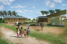
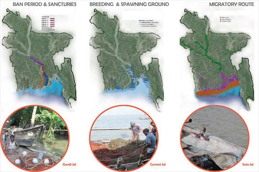
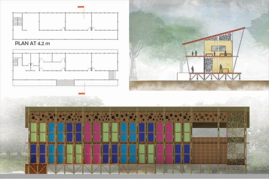
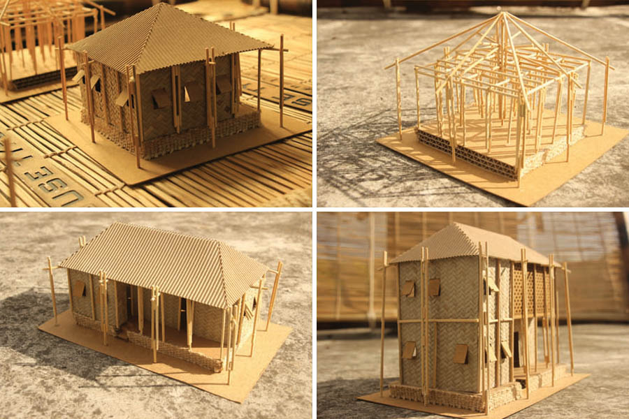
‘River is our life, river is our death’ – portrays of a glimpse, the common lifestyle of the fishermen community on besides of the riverbank of BANGLADESH. With the inception of a “Sustainable fishermen community development by the affected of riverbank erosion, ” the project ‘Jelepolli : Low-cost Housing for Fishermen’ seeks to confirm that the biggest community which is living their life by catching fish (mainly HILSHA fish) and stay over at the side of the river. In every year they are affected by the river erosion and lost their land. The purpose of this project is to provide that community a better solution and also giving them all kinds of facilities. In 40 districts about 0.45 million people are catching fish in Bangladesh and about 2.5 million people are involved with this profession. In the whole world, Bangladesh produces 50-60% of Hilsha fish every year.
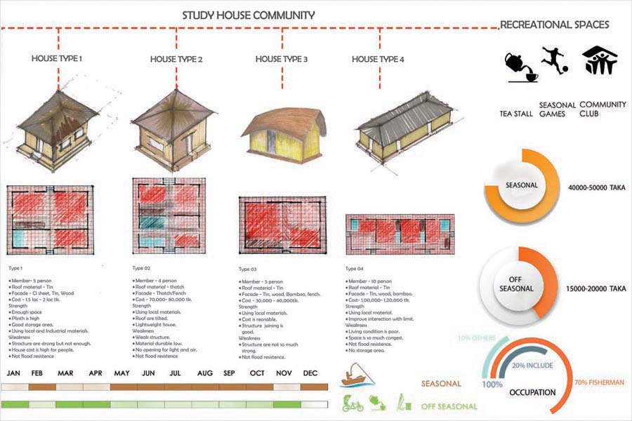
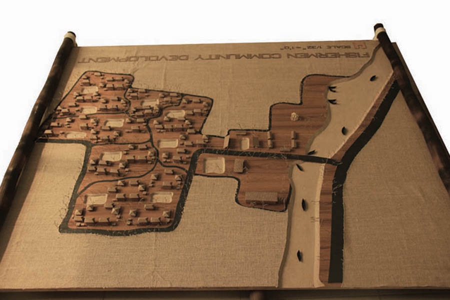
Horina, Haimchar upazilla, Chandpur is one of the oldest fishing communities of Chittagong. There are 18 villages of fishermen village with 10,000 fishermen family. Mainly they are caught Hilsha fish in the lower part of Meghna river. Constantly fighting with natural calamities and extreme poverty these extraordinary hardcore fishermen are surviving on their sheer will-power. The living condition of these people is very poor and unhealthy. Their houses are not strong enough to protect them against natural disasters. An appropriate housing solution must be derived to provide these deprived hard working people with the better living and working spaces. Disaster alertness is also one of the major concerns. This project is for preserving the traditional fishing communities of Chandpur which is a very important part of our culture and tradition. Most of the time they fishing in the river but in the off-season or ban period of illish they are doing other work (like- net weaving, rickshaw pulling, tea-stall etc.). The wife’s of the fishermen are doing household work but in the off-time, they stitch katha and do net weaving. The children go to school at morning and play games at evening, elders going to community club. The functions are provided in the project by the research of the existing fishermen community. This community connected by 2 transportation system. One is by road and another is by a canal. Fishermen caught fish whole night, after selling fish they are going their home by canal and anchor their boat into boat anchoring place. In every year river eclipses their land and house. So their life becomes vulnerable.
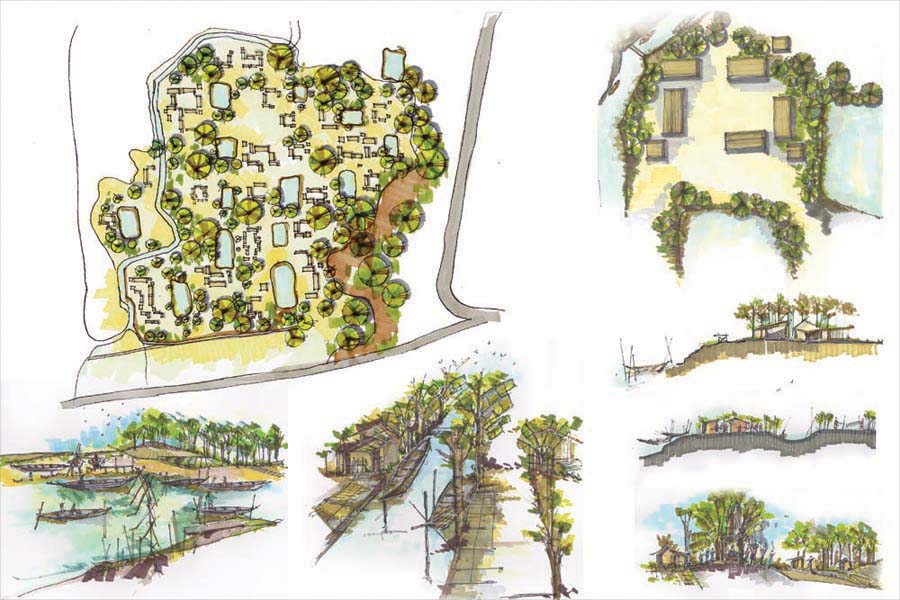
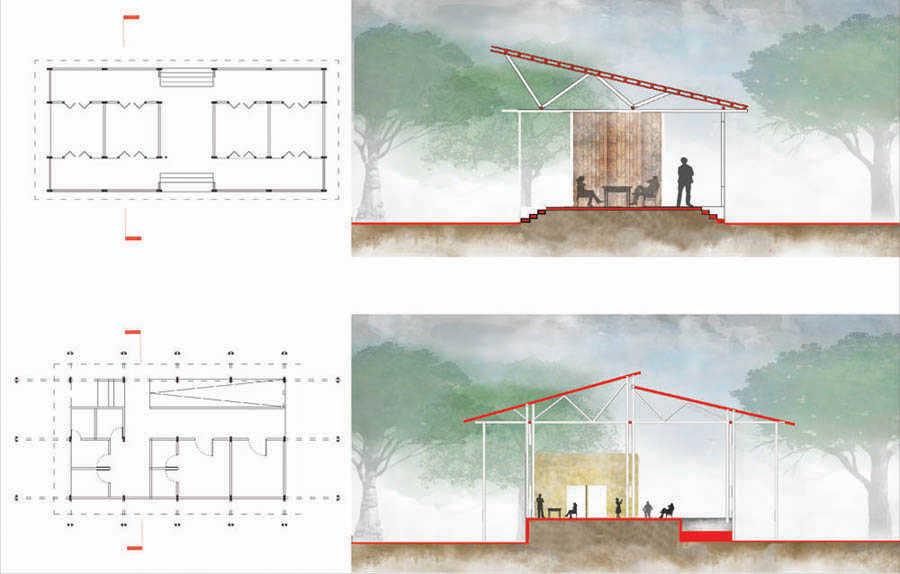
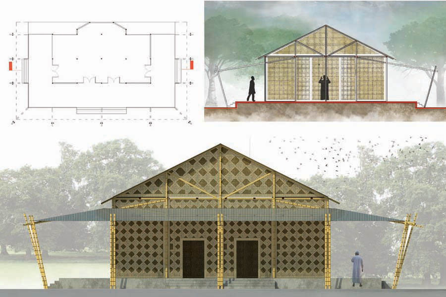
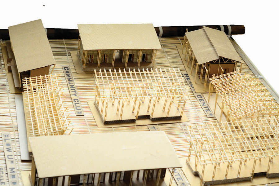
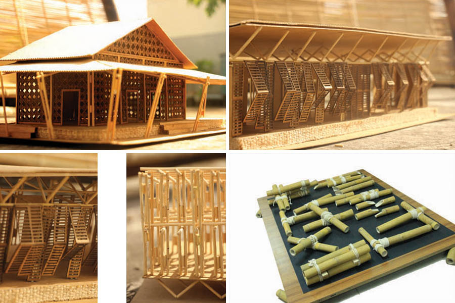
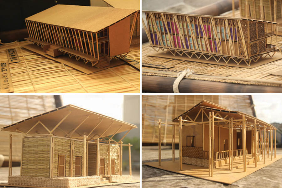
The government of Bangladesh decides to give the fund to rehabilitation this oldest community of Bangladesh. In the project there accommodation of 100 families with all facilities. Mainly average fishermen are Hindu in religion but here most of the fishermen are Muslim. School, Mosque, Health center, Training center, Community club, Celebration space, Boat making & anchoring space, Bazar, Playground etc. all facility are given here by the doing local survey of this community. There are 3 house types in the community. These types are interconnected with each other by following the chain of a family member. Portable dwelling units can offer a solution as, at eviction, dwellers can dismantle their house and move to others place where they can save from river. A modular structure gives the user to make their house. Bamboo, rope, cement sheet are use as materials. The techniques of the bamboo structure are common for local people because of, they can easily build their house. Sustainable construction knowledge will disseminate among the users as well as a sense of belonging. The services (kitchen, toilet, pond, courtyard, tube well etc.) are common for the families.
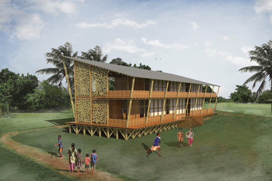
The ultimate aim was to realize a cost effective design solution by reduction the cost of building material & houses and also involving the community in the building process. The mobility pattern of the rural poor requires portable types that can easily tie up bamboo (beams, column, diagonal bracing where needed). In everywhere there are uses of bamboo in different types because of the availability of bamboo. A school is 2 stories because sometimes flash flood are happens so that people can use it like shelter house. Every year 500,000 people migrated into Dhaka city, so this is the right time to save this type of community by rehabilitation. At the same time, securing fishermen community also ensures that we are saving our river and fishes for enriches the fishermen community.
“This is not about architecture, this is an attitude and an attempt to speak for the muted and muzzled voices.”
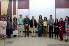
Eminent Architect Md. Rafiq Azam, Principal of the internationally acclaimed design practice SHATOTTO- Architecture for Green Living, has generously awarded Travel Bursary-2016 to Ummehani Binte Ahmed , a student of the Dept. of Architecture of Ahsanullah University of Science and Technology (AUST) for the first time. The bursary, now an award given to the students of many schools across the world including India, Pakistan, Canada, Australia aspires to enhance students’ active learning process of new culture, context, heritage, climate and materials through traveling across Bangladesh and also overseas. The purpose is to inspire and motivate students for a deeper understanding of belongingness.
Ummehani Binte Ahmed receiving the award | Photo courtesy : Dept of Architecture, AUST
’RATB SHATOTTO’ and ‘Seminar and Workshop Organizing Committee, Department of Architecture, AUST’ arranged the competition program among the students on 12th December, 2016 at AUST seminar hall, AUST premise. The program started with the presentation of the participants- Shoshi Karmakar, Tabinda Rahman Chowdhury, Anuva Tabassum and Tanjila Tasnim Srijony on the topics titled ‘Parampara’, ‘My slice of the sun’, ‘Opekkhar Shopnobunon’, ‘Where I am is who I am’ and ‘Loudness of silence’ respectively. Associate Professor Ar. A.B.M. Mahbubul Malik, AUST, Ar. Nur E Zannat Jui from RATB SHATOTTO and Dr. Saymon Zakaria, Assistant Director of Bangla Academy were Present at jurors.After the presentation, Ar. Rafiq Azam shared the history, intention and footprint of RATB. “In the year 2008 RATB was mainly formed to have a platform for sharing knowledge across the globe” said Ar. Rafiq Azam.
Photo courtesy : Dept of Architecture, AUST
Ar. A.B.M. Mahbubul Malik delivered the concluding remarks with vote of thanks to the organizers, grooming team, the audience and announced the winner of RATB 2016.Umme Hani Binte Ahmed, a fifth year student was awarded the Travel Bursary, 2016 and she will get the chance to visit Sri Lanka for 7 days and meet the leading architects in person. The bursary was awarded to her in the form of travel costs and subsistence allowance.
Associate Prof. Dr. Shehzad Zahir and Asst. Prof. Ar. Sujaul Islam Khan moderated the program. Head of the Department of Architecture (in-charge) Professor Jasmin Ara Begum were present at the program along with faculty members and students of the Department of Architecture, AUST.
সিলেট সরকারী কলেজ প্রাঙ্গণে নির্মিতস্মৃতিসৌধ -‘আশ্রয়’ সৃষ্টির নেপথ্য-ভাবনা :
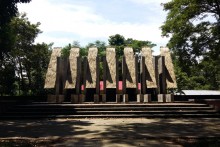
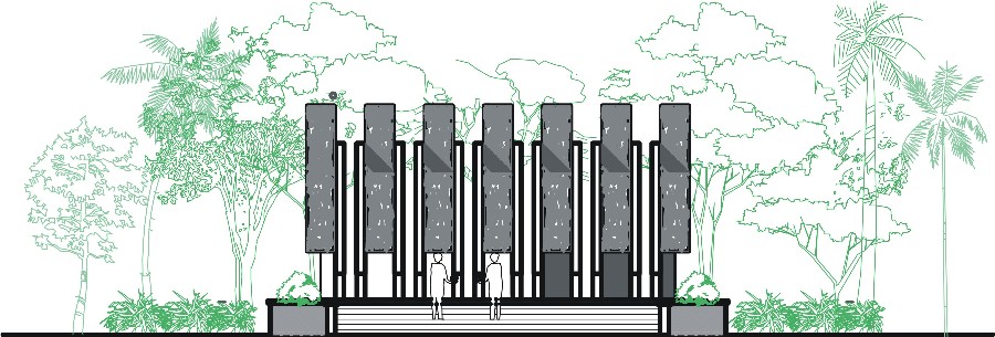
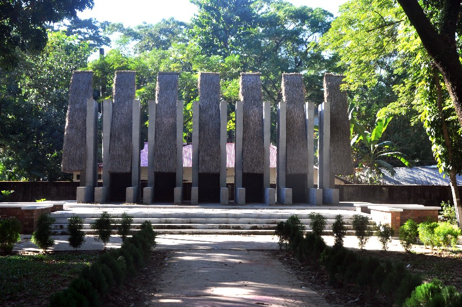
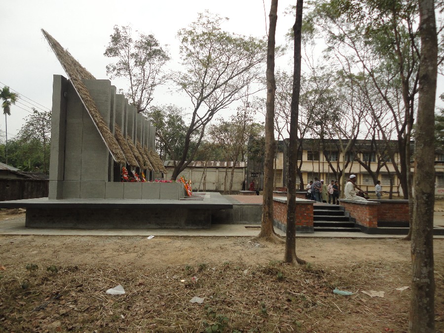
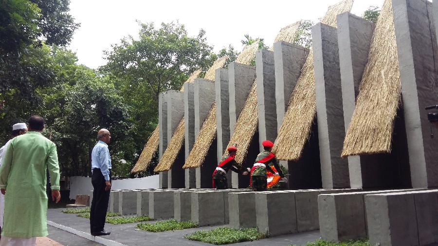
এই স্মৃতিসৌধটি সাতটি খড় বিছানো হেলানোতল কে পাশাপাশি বিন্যস্ত করে এমনভাবে ডিজাইন করা হয়েছে যাতে সবগুলোকে একত্রে দেখলেএকটি কুঁড়েঘর মনে হয়। প্রতিটা হেলানো তল এক একজন বীর শহীদের মৃত্যু-চিহ্ন (epitaph)।এরাই বাংলা মায়ের বুক-খালি-করা দামাল ছেলের দল। ১৯৭১এর মুক্তিযুদ্ধে অংশগ্রহণকারীদের অধিকাংশই যে পল্লীমায়ের সন্তান তা বলাই বাহুল্য। তারা সেদিন কুঁড়েঘরের আশ্রয় ছেড়ে জীবনের বিনিময়ে স্বাধীনতা এনে দিয়েছিল আমাদের। ৭১-এ ওদের এনে দেওয়া স্বাধীনতাই আজ আমাদের একমাত্র আশ্রয়।
Monument for Martyrs at Tilagor, Sylhet. Image by Kshiti Sthapati
Monument for Martyrs at Tilagor, Sylhet. Image by Kshiti Sthapati
যদি সেইসব বাংলা মায়ের দামাল ছেলে বীর শহীদদের স্মরণ করতে হয়, তবে জাতি হিসেবে আমাদের স্মৃতির মিনার বা সৌধ হওয়া উচিৎএকটা বিশাল্ আকারের ‘কুঁড়েঘর’- যা আমাদের অতীত ঠিকানার সত্য-স্মারক,আমাদের গৃহে মুক্তির আলো এনে দেওয়া বীরদের আঁতুরঘর। এই সৌধটি মাটির দিকে ঝুঁকে আছে। উচ্চতা খুব বেশি নয়। ফুট পনেরোর মতো। এর সামনে দাঁড়ালে মনে হবে আমাদের পাড়াগাঁয়ের কোনো ভিটের সামনের উঠোনে দাঁড়িয়ে আছি। মনে হবে এই বুঝি সাত-রাজার-ধন মানিকেরা বেরিয়ে আসবে। ইচ্ছে হবে ’মা’ বলে ডাক দেই। একলা এর সম্মুখে দাঁড়ালে খালি বাড়ির শূন্যতা আপনাকে ঘিরে ধরবে। মনে হবে কারা যেন নেই, যাদের হয়তো এখানেই থাকার কথা ছিল। চকিতে এমনও ছবি ভেসে উঠতে পারে যে, সাত আসমানের পাড় হতে ওরাই এসে এখানে ঘর হয়ে দাঁড়িয়েছে।
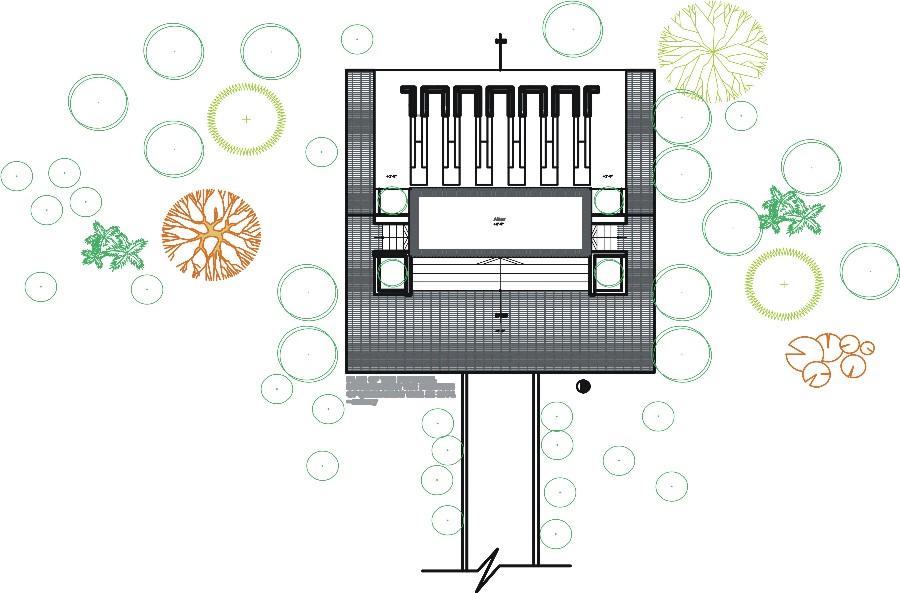
Plan_Monument for Martyrs at Tilagor, Sylhet. Image by Kshiti Sthapati
West Elevation_Monument for Martyrs at Tilagor, Sylhet. Image by Kshiti Sthapati
|English|
Philoshophy behind the creation:
This monument has been made by synchronizing seven inductive straw lying planes in such a way that they form the shape of a hut altogether. Each inductive plane is the epitaph of every valiant martyr. They are the vigorous patriots who have redundant their own mothers’ bosom for their motherland. There is no doubt that most of the freedom fighters of 1971 were from villages. They came out of the village huts and snatched freedom for us. Now this independence is our only ‘Shelter’.
Monument for Martyrs at Tilagor, Sylhet. Image by Iftekher Wahid Iftee
Monument for Martyrs at Tilagor, Sylhet. Image by Kshiti Sthapati
If we want to remember the sacrifice of those intrepid martyrs, the monuments made for them should be like ‘a big hut’—which is the symbol of our true-past; first nursery huts of those braves who brought the light of freedom to us.
Monument for Martyrs at Tilagor, Sylhet. Image by Kshiti Sthapati
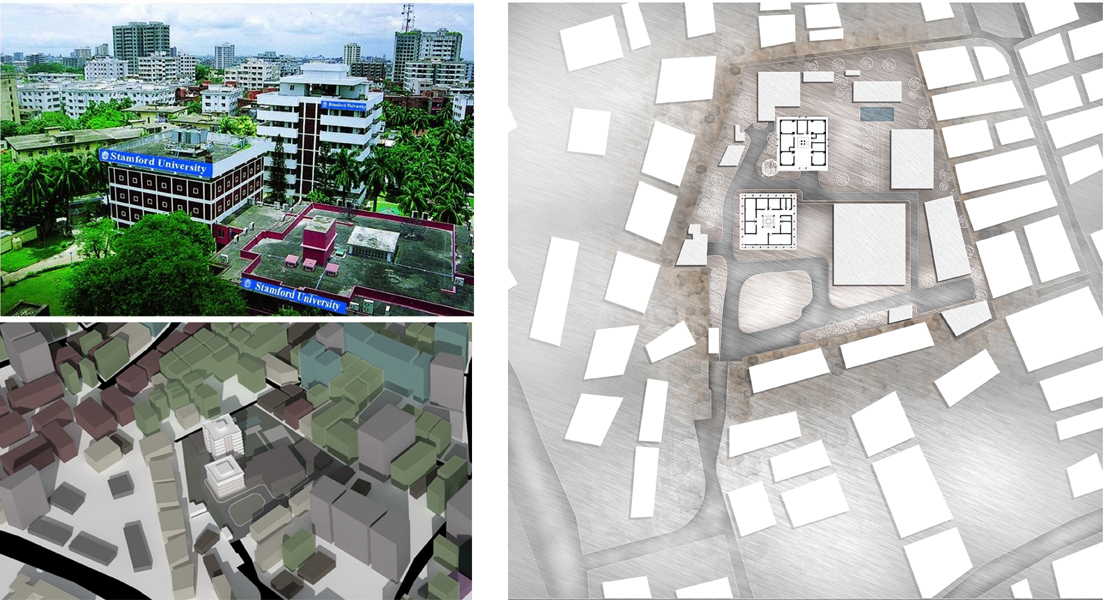
The proposed campus for Stamford University of Bangladesh is located at the heart of the city, in the urban area of Siddheswari, Dhaka. The site area is bare minimum, only 2.5 Acres and surrounded by residential neighborhood. Considering the fact ‘The site area is too tight to have a campus with standard facilities’ – the aim of the design exercise was to explore the possibilities of the concept Vertical Campus in a dense urban context like Dhaka where land is a scarce resource.
Stamford University, Bangladesh is one of the private universities in the country offering higher education since 2002. The university is moving forward with a vision of excellence: “Moving Teaching Excellence from Good to Great”. Currently the University is operating in two campuses located in Dhanmondi and Siddheswari area of the city. The existing Siddheswari campus have their own infrastructures but not sufficient enough to meet the on growing demands of tertiary education in the country. Following their vision, this project is an attempt to moving from Good towards Great.
The campus is envisioned for 15 departments and a language center with capacity to deliver quality higher education for aprox Ten Thousands students. To realize this vision, an estimated of 4,40,000 square feet functional area is required . So, there is no alternative but going for a ‘Vertical Campus’ solution instead of horizontal arrangement of traditional campus layout . However, according to building bylaws the site allows to build a max of 7,45,000 square feet with a parking provision for 350 cars. Another challenge of this particular project is to keep the two existing building intact which are already in the site.
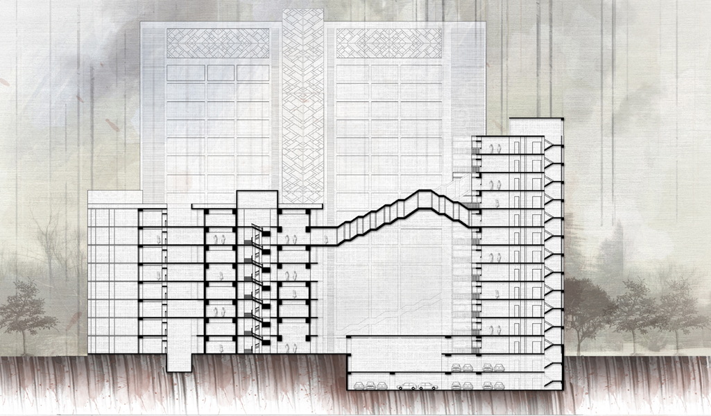
The campus project is conceived to articulate its building blocks around a monumental open courtyard. This central courtyard is designed for public gathering and open performance and also for informal outdoor sports. All the functions are grouped into three zones: Public, Administrative and Academic. Cafeteria, Auditorium, Library, Lecture Hall, Archive, TSC have open access to people hence termed as public zone. Conference Hall , Admission Office , Exam Office , Accounts Office , Register Office , VC office are the administrative functions. Students Block (Class Rooms), Faculty rooms, Laboratory, Indoor Sports etc are the academic functions and hence the heart of this campus project.
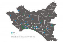
Dhaka South City Corporation (DSCC) has taken up an initiative, titled ‘জল সবুজে ঢাকা’, to allocate areas for 19 parks and 12 playgrounds in the south part of the city. Design proposals were made by 70 architects, which were presented as part of an event that took place in Nagar Bhaban on 5th December, 2016. [Scroll down for index]
A discussion panel and exhibition was held, where views were exchanged in order to finalize the draft designs for the development of the 31 open spaces allocated by DSCC. The project was assisted by SHATOTTO-Architecture for Green Living and JPZ Consulting (Bangladesh) Ltd. as consortium. The panel was attended by mayor of Dhaka South, Sayeed Khokon and other officials of DSCC. The initiative was taken up in order to provide relief and recreation to city dwellers, in the midst of a crowded and hectic city life. In terms of user groups,youth and children were the main priority, since lack of open spaces have deprived them from opportunities of physical activities. The mayor stressed on the important role of playfields for physical development of young children. The mayor also promised putting up additional facilities like Wi-fi connectivity, CCTV cameras etc. at the parks and playfields. At the event, the participating firms displayed their visions of what the dilapidated parks and playfields will look like in the future, in the form of drawings, rendered images and models.The day’s event was organized by Ward 36 and 37 of Dhaka South City Corporation.
Following parks and playgrounds are going to be included in the initiative-
OsmaniUddyan, Panthakunja Park, Hajaribag Park
Jatrabari Park, Gulistan Park, Sharafatganj Park, Motijheel Park, Sadek Hossain Playground, Outfall Quarter Playground, Kalabagan Math, BashaboKhelar Math, Golapbagh Math
Sirajuddoula Park, Sikkatoly Park, Malitola Park, Bangshal Triangular Park, Bangladesh Math, Samsabad Math
Delowar Hossain Playground, Rasulbagh Shishu Park, Bashiruddin Park, Gojmohol Park
Amligola Park, Shahid Abdul Alim Playground, Dhanmondi 3 No. Gate Park
Baksibazar Park, JagannathShaha Road Park, Shahid Nagar Mini Stadium, Balurghat Playground
The following architecture firms presented their designs for realization:
CONSULTANT:
SHATOTTO-JPZ
SUB-CONSULTANT:
VITTI STHAPATIBRINDO LTD |NEXT DOOR CONSULTANTS
TEAM SHATOTTO
SHATOTTO+JPZ |GHORAMI.JON |GOOAT |CUBE INSIDE
TEAM VITTI
VITTI|TKNRK| K2AH| ATELIER ROBIN’S ARCHITECT| MRINMOY AND URBAN LAB| DOORS
TEAM NEXT DOOR
NEXT DOOR CONSULTANTS| REFORM LTD
Visualization of Delwar Hossain Playground by GoAaT. Image courtesy: Ar. Rabiul Islam
Earlier this year, in May, chief engineer of DSCC, Md. Nurullah promised, that they would engage consultants to design the playfields and parks. DSCC’s initiative of ‘‘জল সবুজে ঢাকা’’ is a part of its Tk 1,202 crore project for development of roads, footpath, slaughterhouses, and other facilities in the southern region of the capital. The work is estimated to be completed by 2018.
Google originally released its Timelapse feature in 2013 in partnership with TIME and NASA. Using Earth Engine, the company combined over 5 million satellite images acquired over the past three decades by 5 different satellites (source : Google ) The technology giant hopes its Timelapse programme ‘can inform the global community’s thinking about how we live on our planet and the policies that will guide us in the future’.
Transformation of Dhaka [1984-2016]; source: Google Timelapse | Video encoded by Saimum Kabir/ CONTEXTbd
Another new feature of Google Timelapse application is, viewers can create their own timelapse tour that moves from one destination to another over time using the Timelapse Tour Editor. Google has also released Timelapse video (Youtube highlights) of 24 different places across the globe which unfortunately doesn’t include Dhaka. CONTEXTbd first time is releasing the video with customized Timelapse tour by using the application Timelapse Tour Editor by Google. Added to that, zoom in of some selected area of the city, where transformation is rapid and more rigorous, are also included for the viewers. The images are showing how fast the fringe areas of Dhaka have been urbanized and how the process of water-to-land conversions for urban construction has been intensified over the past 12 years both by the private developers and government institution.
Basundhara R A (between 2004-2014) | Source: Google Earth
Eastern housing, Alubdi (between 2004-2014) | Source: Google Earth
Mirpur DOHS (between 2004-2014) | Source Google Earth
Kuril Flyover (between 2004-2014) | Source Google Earth
Uttara Model Town (between 2004-2014) | Source Google Earth
Check out the new Timelapse for yourself below, or on the Google Earth Engine website. To explore the feature, you can type in the name of a place in the search bar, and then move the timeline along the bottom to choose which year you’d like to view. You can also zoom in and pan to experience the changes of any area in more details. Enjoy!
‘In the experience of art, a peculiar exchange takes place; I lend my emotions and associations to the space and the space lends me its aura, which entices and emancipates my perceptions and thoughts. An Architectural work is not experienced as a series of isolated retinal pictures, but in its fully integrated material, embodied and spiritual essence. It offers pleasurable shapes and surfaces moulded for the touch of the eye and other senses, but it also incorporates and integrates physical and mental structures, giving our existential experience a strengthened coherence and significance.’ [ The Eyes Of The Skin: Architecture and the Senses _ Juhani Pallasmaa]
A few days back we got a chance to have a conversation with Juhani Pallasmaa regarding this project. Going through the images of the project, he suggested to use ‘literature’ instead of ‘drawings’ and stretched on the use of the term ‘metaphors’ instead of ‘concept’ while explaining the project which eventually reinforced our intention to express the ‘existential experiences’ this architectural intervention has to offer.
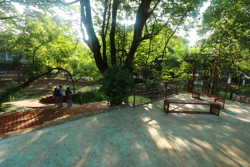
Surrounded by significant landmarks like Central Mosque, Central Library, DUCSU, Modhur Canteen and also the new building of the Faculty of Social Science, the open space failed to create any significance regarding the usage. Despite of being located at the heart of university of Dhaka, the area remained ‘unattended’ for years. The place itself had nothing to offer to the users, and was being used for shortcuts and dumping zone of construction debris for several years. Natural setting was random but guided by the influences like sunlight, condition of the soil and less human intervention.
The objective of the project was to create a meeting place for the young mind, holding small gatherings which may act as a place for contemplation and reflection to the students and faculties. Maintenance of a open landscape in a prominent area like this demands additional attention and the requirement of a semi-open food kiosk emerged as the catalyst to maintain the site as well as making the space lively.
The project, from the moment of inception to the phase of completion, can be expressed through multiple ‘metaphors’:
Choreographed Encounter >> The design approach focused on creating a place for contemplation where the users, primarily consisting of young age group, can take a ‘momentary pause’ in between their campus life. Mainly based on the very basic idea of ‘Dig and Mound’, traditionally used in our context, topographical layers are created within a range of 3 feet below and above ground to create a landscape terrain. The shapes and spaces in the land formation emerged from the unique site specific pattern of existing trees and the surrounding built forms of distinct characteristics in terms of both aesthetic and program. The design intervention offers a ‘place’ for ‘choreographed encounter’ to the users through creating an extended reading area from the central library, gathering place after prayer at central mosque, extended discussion ground adjacent to DUCSU and Modhur Canteen.
The design approach focused on creating a place for contemplation where the users, primarily consisting of young age group, can take a ‘momentary pause’ in between their campus life. Mainly based on the very basic idea of ‘Dig and Mound’, traditionally used in our context, topographical layers are created within a range of 3 feet below and above ground to create a landscape terrain. The shapes and spaces in the land formation emerged from the unique site specific pattern of existing trees and the surrounding built forms of distinct characteristics in terms of both aesthetic and program. The design intervention offers a ‘place’ for ‘choreographed encounter’ to the users through creating an extended reading area from the central library, gathering place after prayer at central mosque, extended discussion ground adjacent to DUCSU and Modhur Canteen.
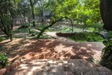
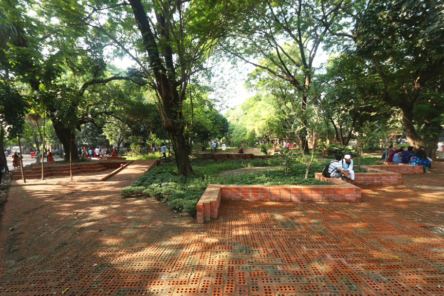
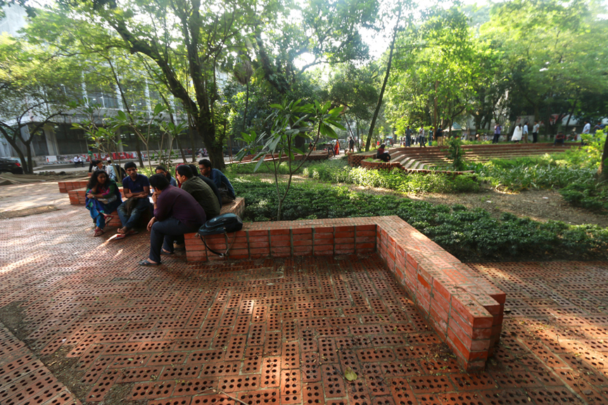
An Archive of Memories >> For transforming a ‘non-place’ into a ‘place’ that is able to create an impact to the users, the design strategy focused on creating ‘an archive of memories’. A sunken reflecting water body holds the reflection of the big Rain Tree, part of the library façade from certain angles, the ever-changing phenomena of light and shade, the sky, the cloud, offers a place for contemplation. The ‘Hijol Tree’ planted at the center of the water embodies an image to recall memories of the village pond. Use of materials is explored to create a multi-sensory experience infused with nostalgia.
Material Compatibility >> Perforated bricks were used with a patterned combination of soft-pave to hard-pave. Red Oxide coated metal installations combined with turquoise colored neat cement finish infuses an essence of ‘ruins’ and creates a rich ‘peripheral image’.
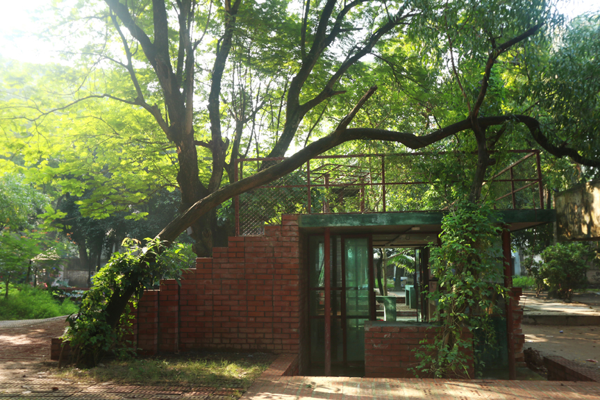
Elements ‘Placed’ in the Terrain >> The semi-open café emerges within the gap created by the changes in topographical layers which start from the sunken steps surrounding the water body and ends near the intermediate level of the large ‘Kanakchura tree’. The continuous surface takes the form of a stepped gallery facing the sunken water body with the façade of the central library as the backdrop. Hanging metal bridge enhances the directionality towards the node of the mosque, library, and social science faculty. It allows the free flowing growth of the shrubs, an interplay of lights and shades through its porous body. All of these elements creating ‘pause’ or ‘thresholds’ generates from or terminates towards the existing trees of unique species and foliage.
The Animated Terrain >> Focus has been given to enhancing the essence of the ‘place’ itself by a deliberate design strategy of evolving the ultimate landscape formation from on-site design decisions responding to its immediate surrounding structures of cultural, historic and programmatic significance as well as existing biodiversity. The shadow of the trees, flickers through the leaves spreads through the stepped theater surrounding the water body and continues up to the stepped gallery and in certain moments of a day stretches up to the turquoise-blue roof of the pavilion-café. The place becomes animated with the ‘aparajita’ fallen from the metal shade on the metal benches while sipping the early morning tea. The soft-paved brick covered platform gets covered with the yellow kanakchura flowers.
Enhanced Biodiversity >> As a climatic attribute it varies with the presence of elements like water, vegetation, quality of surfaces around, also describes the morphology of a space. The shades, the permeability of light, flow of the wind all can imitate a particular memory or memories, a deep sensory perception.
The site was filled with large trees such as Rain Trees, Kanakchura, Mango, Jackfruit, Mahagony, Neem, Kadam, Bakul etc along with rare species of Figs. Fruits from fig trees attract the rare ‘BoshontoBauri’ in the site along with other common birds like doyel, chorui etc. Beji(mongoose), Kathbirali (squirrel), were to be ensured their natural habitat to retain the existing biodiversity and hence the ‘design intervention’ also includes ‘places’ for them besides humans. Fruits and Flower bearing plants such as Dalim, Kamini, Radhachura, lantana, Joba are planted to attract butterflies and birds. The central water body has water loving plants and small fishes to ecologically sustain the cleanliness of the water. Ever since the water body is created, it is being used as a bird’s bath for the birds of the locality. Flights of birds in pairs touching the body of water are now a common phenomenon occurring at the site.
** The word ‘Non-place’ used in the title refers to the term coined by French anthropologist Marc Augé. He used this term to refer to spaces of transience where the human beings remain anonymous and that do not hold enough significance to be regarded as “places”.
.
<< Project Information >>
Architectural Consultant: SthaNiK Consultants
Lead Architects: Saiqa Iqbal Meghnaand Suvro SovonChowdhury
Construction: Nazmul Ahsan Rajan, Arcadia Architects and Engineers
Associates:Saad Ben Mostafa
Location: Faculty of Social Sciences, University of Dhaka
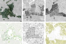
Ramna Area is not a clearly defined zone. Officially there is not such a thing as ‘Ramna Area’. The historic maps show that the name ‘Ramna’ appears on different spots on maps from different time periods.
The question surges what Ramna Area exactly is? Can this area be distinguished from its surroundings? What are its characteristics? Where does it start and where does it end? What are the limits of Ramna?
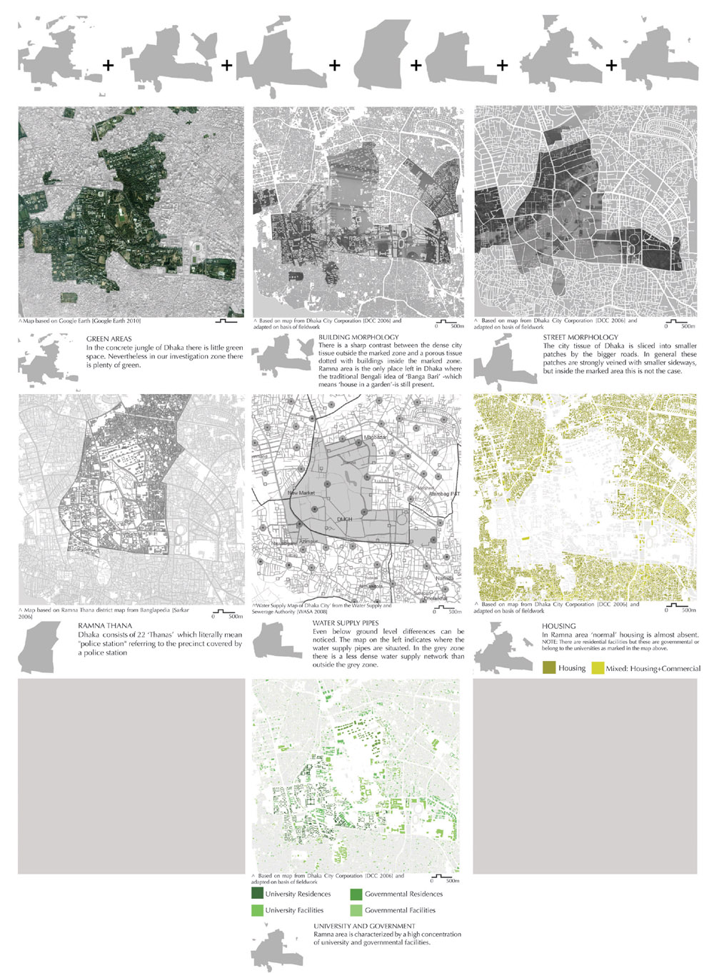
It is hard to say what characterizes Ramna Area but when walking around in this neighbourhood one can somehow ‘feel’ the difference with the rest of the city. Is it because of the presence of so much ‘green’, because of the functionality of the buildings, because of the physical characteristics or is there something else? There is not one single element that defines Ramna but it is rather a mixture of many elements. To tackle the question where the limits of this area are, different layers are looked at resulting in different footprints.
The heart of Ramna is dotted with cultural important buildings configured in more or less a circular form. The assembly of these buildings is often referred to as the Cultural Belt.
The Cultural Belt embraces and interlaces the two parks of Ramna Area: Suhrawardi Udyan and Ramna Park. This central zone we define as the ‘Main Stage’.
The cultural and park qualities are the main attraction poles of the site. Ramna does not only attract people who live nearby but also people from other parts of the city and even from all over the Bengali region.
The people who live within Ramna Area are principally students, government officials and ‘informals’. Students and government officials come to the Main Stage because of both its park and its cultural function. The ‘informals’ are mainly poor people living in the slums, filling up the leftover space in the park area, in little mobile stands or in improvised constructions. They do informal work like vending flowers or snacks. The presence of ‘rich’ people adds an interesting economical perspective to the Main Stage.
DHAKA CITIZENS
The cultural activity of the area also invites citizens from far outside Ramna. Furthermore the presence of 3 important hospitals and the court buildings are another reason for the Dhaka citizens to come. Finally the Stadium Area attracts people from all over Dhaka. Not solely because of the sportive events but also because of the electronic shops and other commercial functions in the stadium building.
BENGALIS
The Cultural Belt does not only facilitate ‘regular’ concerts, theatre plays and expositions but it also stages ‘national’ events like Bengali New Year and the yearly bookfair. These ‘special’ yearly events are a good reason for thousands of Bengalis – both from Bangladesh as from all over the Bengali region- to make the trip to the capital of Bangladesh. More specific to Ramna Area, and more specific to the Main Stage. On such moments Ramna Main Stage becomes the heart of the Bengali Culture
Combining the movement map with the residential map of the locals indicates that there is a specific local segregation in Ramna Area, namely between students and government officials. The yellow and green organic lines represent the movement patterns of respectively the government officials and the students. The map demonstrates that there is only a limited overlap between the movement lines of the students and the government officials. They mostly stay in their own zones. Furthermore the map shows that the south-east corner of Suhrawardy Udyan is not often frequented. This is a very ill-facilitated zone separated from the Court Zone by a impenetrable wall. Therefore this zone will be referred to as ‘no man’s land’.
The main reason of such segregation is the highly concentrated self-reliant structure of the campus. A student can perfectly pass his day without leaving the campus area. There is a place to sleep, to eat, to study, to read, to sport, to relax, for entertainment and so on. When they leave the campus area their movements are rather limited to the west side of Suhrawardi Udyan.
This is a general statement confirmed by the observations. It is clear that this is a simplified vision of reality: now and then students also can be spotted in for example the Ramna Park but their number is noticeable limited. For the government officials the same logic can be applied. However their movement outside the government enclave is rather limited to Ramna Park.
From a micro-geographical perspective there are remarkable nuances concerning the presence of women in Ramna Area as shown on the map.There are student residences and schools that are women restricted areas. In some zones the presence of women is remarkably higher than in other areas. These zones are labelled as ‘High’ and ‘Medium’ women presence.
In the first part of the 20th century, many institutes settled in Ramna Area. The presence of the institutes and the large chunk of green -Ramna Park and Suhrawardi Udyan- mixed with the historical and political importance ensure the ever growing interest of the whole region and made it the heart of Dhaka. The Cultural Belt is composed of a hodgepodge of monuments, buildings and objects that are contributing to the cultural importance of the area. The presence of these buildings and objects with cultural value play a vital role in the vibrant life of Ramna Area. For example, institutes like Fine Arts often hold exhibitions or provide performances. On extraordinary days, TSC, Bangla Academy, Fine Arts Institute etc. play a crucial role in facilitating all kind of celebrations.
The zone which is called ‘Park Zone’ includes the two largest open spaces and at the same time the two most important parks of Ramna Area. Ramna Park is located north and Suhrawardi Udyan south and both are the part of the Main Stage of Ramna Area. The fact that the parks are surrounded with cultural, institutional, administrative buildings results in a very intensive use. Not only the traffic jammed street between Ramna Park and Suhrawardi Udyan makes a striking separation between the two but also the way of accommodation, use and users of the parks make a notable distinction between the two. Ramna Park is attractive for its natural and quiet environment, its safety level that is higher because of the many guards, its big amount of shade and the location. It is often used by the more wealthy part of society. Suhrawardy Udyan is far less accommodated than Ramna Park. Because of the lack of benches and lights, for example, lots of movable stalls are present in the park. The people accommodate the park by themselves which gives Suhrawardi Udyan a unique atmosphere. The reason why this park is still attractive, despite the lack of accommodation, is the infrastructures and the monuments in the park and the relationship with the important buildings of the Cultural Belt. In both of the parks a water body is present. The people of Bangladesh feel related to water, so a pond is one of the most desirable items in a park. The two parks are both encircled by fences, which gives a closed environment and creates spaces which are not used by park visitors but often by floating people.
This zone is named Court Zone because this zone is dominated by judicial buildings. The building that is most prominent and sets the tone for the other buildings is the New Supreme Court Building. The non-judicial buildings that are located in the Court Zone are less outstanding. They are even mostly invisible from the street. This invisibility also applies for the slum that is located between Suhrawardi Udyan and the Old Supreme Court Building.
This zone is called ‘Democratic’ Zone because it is the commonly used name for this zone. In 1905, a good number of residential houses were built in the Minto Road area for High Court judges and high-ranking bureaucrats (Environment of capital Dhaka). Even though the country and its system changed enormously during the last century, the Minto Road that is part of the Democratic Zone is still claimed by the high-class government officials. The difference between the residential areas throughout Dhaka and the Democratic Zone, which is also a residential area, is striking. First of all, only with one look on the map, the difference in density is clear. The buildings are surrounded by large pieces of green and open space, which is often called, ‘a house in a garden’ and gives in comparison with other residential areas in Dhaka, a very low density of buildings. Another privilege they enjoy, next to the low density, are the facilities that are provided in between the boundaries of the zone, which are reserved only for the residents. The whole zone is encircled by mostly walls and sometimes fences. It is possible, as a non-governmental official to enter the intersecting roads. Even on these roads, walls with a few entrances are the only view you have, despite of the amount of green. The exclusivity is fostered by physical and mental boundaries. The threshold to enter is very high. This is also one of the examples the pieces of land that are claimed by the upper group of society. These pieces of land could be used better and more intense. Dhaka has a lack of open and green space that is open for the public and can be used by every group of society. The people who are in possession of open space or less dense areas do not want to share because open space in Dhaka city is a precious good.
Dhaka University was founded in 1921 and is the oldest and largest university of Dhaka. It started as a modest institute in Ramna Area and expanded to its present volume during the years. It is interwoven with cultural buildings of the Cultural Belt. The university claimed and appropriated a big part of this cultural space but a more versatile look also indicates the contribution of Dhaka University to the cultural entity of this area. On the other hand, the relation between the Campus and the park area is missing. It seems that there is a threshold between these two. The first kind of threshold is the double physical boundary. Fences and walls enclose big parts of the campus and the two parks. These boundaries make it more difficult to pass from one site to another despite the fact that they are adjacent. The Campus area is well provided with spaces where you can play football or cricket, places where you can hang around and relax and some food corners. In interviews with a few students, they said they rather did not go to the park. The first reason is that they are provided well with everything they need and the second reason is that there are rumors that it can be dangerous. This too is a vicious circle, if it can be dangerous, why should people go there and if they do not go there they never will be convinced of safety.
The buildings in this category are buildings that did not fit in any of the groups above, but still play an important role for the activity in Ramna Area.
Bernard Forier, Karoline Peeters, Thomas Raskin & Bruno Ronsmans are K U Leuven graduates. The article is the executive summary of design thesis entitled ” Transcending the Limits of Public Life in Ramna Area: A Design Investigation in Dhaka-Bangladesh” completed in academic year of 2011-12.


![Google Enables Viewers to Experience the Transformation of Dhaka [1984-2016]](https://contextbd.com/wp-content/uploads/2016/12/Context_feature_dhaka-1984_2016-220x147.jpg)