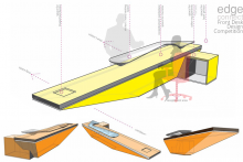
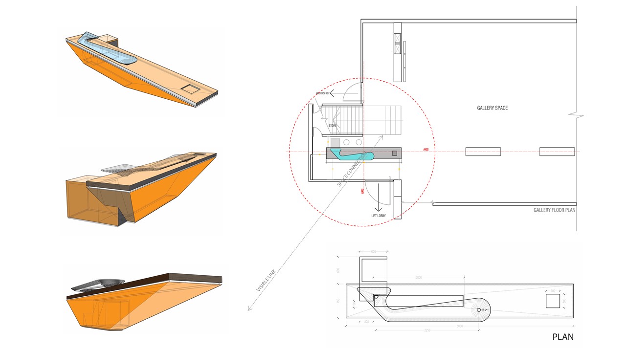
The Edgewater building which is awarded for its architectural excellency itself a building artwork for its true expression of forms and materials. As a designer when I think a detail which will be a part of this building, my mind always reminds the building itself. So, my design has a connection with building by boldness and clarity of the design, materialist expression and sculptural quality. As a part of the gallery, I think the front desk should be a part of exhibit elements. When visitor’s will come, they have to stand in front of it, feel it by touch and think about it.
‘Edge Connect’ is a self-described theme which can be the idea of the design. I have started with a rectangular box with basic functional dimension, subtracted it such a way that the edge of the object becomes more visible and powerful.
The gallery ‘s best part is the location which is besides the lake and the building’s name is “Edgewater”. Then why not we make an interpretation of this beautiful link by placing a glass top with the offset of multiple layers so that every edge can be perceived?
A cantilever has been kept its edge so that everyone can feel the floating effect.
The whole table has been designed as a monolithic concrete sculpture with thin edge. To make it functional, there is a layer of 10mm glass has been stacked together such a way that all the load of the glass will transform by two point. For strengthen of the concrete, necessary reinforcement will be there while construction. To make the surface smooth, the shutter work material must have smooth surface like veneer board.
MASCO SCHOOL – a newly founded elementary school located in Kanchan, Rupganj. This English medium school is at their initial stage and currently operating their curricula from play group to KG-1. By next two years there is a plan to expand from class-1 to class-7.
The design process started with respect to the nature and the character of the local landscape. The challenge was to keep the height, length and proportion of the building mass at intimate scale to the surrounding landscape. The 3 storied building with 340 sqm per floor area is modest in size and modern in volumetric expression, functionality and structural simplicity.
The north-south elongated school building is rectangular in plan with service areas like store, toilet etc. located at east and west corner of the block. The classrooms in each floor are connected by a single loaded corridor wide enough to host occasional functional activity. A centrally located staircase is connecting all 3 floors vertically.
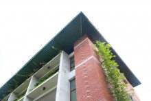
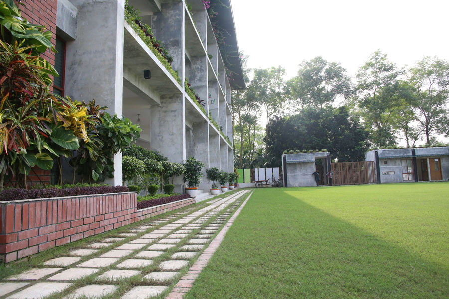
Design effort has given to merge the building with the surrounding vegetal landscape and open spaces. Local plants and creepers are introduced to cover the hard surface of the buildings and boundary walls as well. Various plants are also used at the corridor side railing which ensure additional protection for the children and give a new definition of typical school corridor. For proper wind flow and to keep the building in comfort temperature screens are used at the south side of staircase area and east-west side of service block and eventually has given a monolithic look.
This project is constructed with very simple frame structure (beam and column) and steel roofing. Local and available materials are used for the project. Machine made brick, 3.75” x 3.75” screen, neat cement finish, composite windows made of wood and glass primarily with limited use of wooden texture aluminum panel. Windows are casement and pivoted type. For enhancing the roughness rustic tiles have been used as a floor finish material. In the landscape concrete blocks are used for walkway.
The project is completed in April 2015 within less than year after commencement in July 2014. However during the construction period multitasking enthusiasm and practical issues such as limited vehicular access to the site, high material transport cost and time management etc continuously interrupted the project timeline.
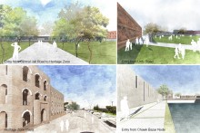
Being located in the heart of Old Dhaka, the Central Jail of Dhaka is bearing the footmarks of all the cultural, social, political changes that took place for more than 200 years. It exists as an integral part of the morphology and infrastructure of old Dhaka and yet detached from its surroundings, with its boundaries. The 22’ high boundary walls of colonial period create a mixed sense of curiosity, fear and safety among the citizens.
Appropriating Central Jail, Old Dhaka | BUET
While reintegrating the core jail area with the surrounding context, our intention is to facilitate the area conserving and preserving the ‘Cultural Heritage’ of Old Dhaka, ensuring new developments not coming in conflict with the heritage site with all preserved buildings for adaptive reuses, trees and intimate open spaces. Reintegrating the central jail area will establish the connection between individual interest, communal facilities and the time-honored culture. The social values, norms, knowledge, language customs, manners, foods, streets, celebrations, gatherings, lifestyles all these together are the identity of the “Old Dhaka”.
Appropriating Central Jail, Old Dhaka | BUETAppropriating Central Jail, Old Dhaka | BUET
The landscape of Bangladesh, as if, looks like a magical tapestry in green woven intricately by nature which is absent from the old Dhaka city. As the Central Jail of Bangladesh is relocated from Najim-Ud-Din Road (23°43’9.10″N, 90°23’48.14″E) to Keraniganj (23°39’30.46″N, 90°22’52.27″E) after 228 years of running, the vast land has no more use as its previous purpose but has the potentiality to be a breathing space for the densely populated Old Dhaka city. In Old Dhaka open spaces are scattered here & there which may not be used to their full potential and not sufficient for that area. We designed this site not merely as an urban space but also conserved the historical essence of the previous central jail.
Appropriating Central Jail, Old Dhaka | BUETAppropriating Central Jail, Old Dhaka | BUET
Design Process
We zoned the site into two public spaces along with Najim-Ud-din Road and Urdu Road on both side of the historical zone providing public facilities( restaurant, parking, open field for celebrating any kind of festivals).These public spaces are connected with a foot-over over bridge.
Historical Zone: There is a historical zone between these two public spaces where we conserved 6 historically important buildings. Four British colonial buildings (Padma, Meghna and Surma, were used as cells for the prisoners, a hospital) and two museums known as “Char Neta Museum” and the Bangabandhu Museum.
Commercial zone: A multi-storied building at the north of the site which provides shopping complex, recreational and leisure activities for the urban dwellers.
Educational zone: There is a school with a playground at north.
Community space: Near the historical Chawk bazar a gathering & community meeting space (Chawk plaza) is provided with green roof to hold the urban crowd.
Appropriating Central Jail, Old Dhaka | BUETAppropriating Central Jail, Old Dhaka | BUETAppropriating Central Jail, Old Dhaka | BUET
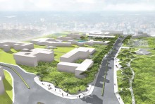
This urban project is an attempt to find the spirit of vibrant urban dimension of Shahbagh and associate it with the pursuing of knowledge, art, culture exclusive only to Shahbagh and its rich heritage. The studio task tries to explore how taking context as a tool, a design can generate events and ultimately shape urban spaces through formal expression.
Shahbagh: An Urban Reconciliation | UAP
Shahbag area is one of the most active zones of urban Dhaka whether it is culturally or politically, publicly or as educational district. Library is the universe of knowledge situated in this tremendous context has introduced many urban issues and challenges and to deal with. So here the concept is to activate the whole zone from TSC to central library at Shahbag. As this area is dedicatedly responsive to the events of art and culture so the concept is to use this idea for the whole zone. The idea of exhibition walls is inspired from the event of ‘gonojagoronmoncho photographic exhibition’ back in 2013 & our very favorite Art College art wall.
Shahbagh: An Urban Reconciliation | UAP
What if the walls could be dissolved and given a purpose to connect through art and culture. Then the walls could be the media for public to speak up. There are walls for artists to exhibit their works for people. On the other hand we have opened up spaces which will act to increase the public interactions. “the more people interacts the more activity grows” we have proposed to revive the ‘Chobir hat’ not only for exhibitions but also for the public events like open concerts , fests , shows. And also for opening up this areas will increase the sense of belonging to different groups and promote positive usages along the urban edges.
Shahbagh: An Urban Reconciliation | UAPShahbagh: An Urban Reconciliation | UAP
The project further explores the context of public library at Shahbag upon the urban dimensions of the built form and site, looking at the core values and impacts of the libraries in our societies and translating them as an urban intervention project. So the library is conceived as not just an isolated piece of building rather an urban component, an urban intervention.
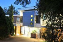
This double story house was about 40 years old with lounge, kitchen, dining, double garage and a car port on the ground floor and 3 bed rooms, a bathroom and deck on the first,. The building was on a 610 sqm sloping lot in Sydney’s south west. The house was facing the street due west and there was a neighbouring house on its north. The house boarded a reserve on its north-east & southern sides.
The client needed to add a home office on the ground floor and an additional bed room with ensuite and a family lounge on the first floor.
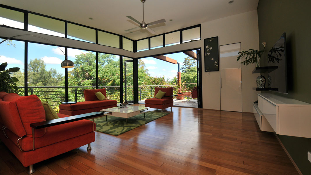
The design concept was to develop a simple solution responsive to the orientation, view and environment around it. The concept was also to keep the house naturally ventilated and maximize the use of the structural timber from the existing carport and back veranda for environmental and cost reasons.
Given that the original construction was comparatively unattractive and not in keeping with the rest of the houses in the street, the new facades both facing the street to the west and the reserve to the south and the east enhanced the environment for people using both.
Relationship of Built Form to Context
By giving the house a more striking and solid façade at the front, the house was able to better conform to the houses that surrounded it on the street. The more fluid, transparent, open façade at the back on the southern and north-eastern side was more reflective of the open parkland of the reserve.
The design was able to meet all the requirements of the client, most notably completing the building in the shortest amount of time without significant disruption to their living arrangements.
Integration of Allied Disciplines
The structural and civil engineer was able to help in the process of designing a higher level roof and a drainage system.
The use of light weight cladding avoided the need to boost the existing foundation and the use of existing structural timber reduced the cost further.
Sustainability
The use of existing structural material reduced impact to the environment. The maximization of natural ventilation added to the sustainable use of energy in the future.
Response to Client and User Needs
An unintended outcome was that the deck facing the reserve added to both the security environment of the house and the reserve.
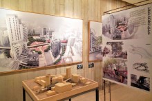
In order to tackle the pressures created by uncoordinated planning initiatives that are leading Dhaka to an inevitable environmental degradation, Bengal Institute for Architecture, Landscapes and Settlements has been involved in researching and generating new ideas to rethink the urban future of the capital. The ideas were presented at an exhibition that was officially inaugurated on 15th October, 2016.
The exhibition titled NEXT DHAKA: NEW VISIONS OF THE CITY, was launched with the Honourable Finance Minister of the Government of Bangladesh, Mr. Abul Maal Abdul Muhith as Chief Guest. Bengal Institute, an affiliate of Bengal Foundation, has presented its vision at the exhibition in the form of architectural drawings, computer generated renderings, animation videos and models. The visions for a new city were considered at three different scales: regional, inter-city, and civic realm.
In the past decade, Dhaka has been listed as one of the least livable cities numerous times and its dwellers have been deprived of the benefits of quality urban life. With the goal of returning Dhaka to somewhat of its previous glory, Bengal Institute has invested its resources to study, research and design solutions for creating alternative visions for a unique, greener and livable city. The urban design interventions were proposed for two critical areas: Buriganga Riverbank and Gulshan-Kawran Bazar civic corridor.
For the Buriganga Riverbank, the proposal includes: introduction of appropriate riverside activities, connecting north and south riverbanks with a continuous promenade, connecting civic and historic buildings, a large, new plaza called Sadarghat Chottor and generating an active water-based transportation system by creating ghats and stations for river buses and river taxis.
For the Gulshan Avenue to Kawran Bazar civic corridor, the proposal includes: providing a new scheme and standards for the sidewalk that connects major points, hubs and destinations; converting specific city properties to civic spaces with walkable public passages; creating generous public spaces and plazas and promoting parks and gardens.
A proposal was also made for a ‘Dhaka Nexus’ – a system in which the city and its surrounding neighbourhoods are brought under a dynamic and harmonized formation. The system would support innumerable and varied settlements by connecting all old and new nodes and hubs. Here, three transportation rings were proposed: the first ring connects Tongi, Savar and Keraniganj; the second ring connects Narayanganj, Bhulta, Pubail, Gazipur and Hemayetpur; and the third ring connects Munshiganj, Mawa, Narshingdi, Kapasia, Kaliakor and Manikganj. The proposal includes expressways, circular fast train line, circular waterways and radial roads and trainlines.
The research and design team is headed by Kazi Khaleed Ashraf, Saif Ul Haque and Masudul Islam Shammo. The ‘Next Dhaka’ exhibition is open for all and will run from 1st November to 20th November, 2016, from 3pm to 8pm, at Bengal Art Lounge, in Gulshan 1.
Open Urban Design Competition for Model Streetscape of Arterial Mirpur Road (from Dhanmondi, Road 27 to Nilkheet Intersection) | Organized by Dhaka South City corporation in association with Institute of Architects Bangladesh
Dhaka South City corporation (DSCC) in association with Institute of Architects Bangladesh has organized an open urban design competition to seek for innovative and responsive urban design interventions towards achieving a sustainable, lively, accessible , user friendly and integrated urban streetscape that would be an executable model for urban streets for the segments from Dhanmondi road no 27 (old) to Nilkhet.
The purpose of this competition is to explore the challenges of converting existing overcrowding streets of Dhaka into that of a very pleasant accessible one. Outcome is expected in creating a comprehensive vision and plan considering future landuse , accommodating pedestrian environment, rehabilitating the floating trades on the street, streetscape, integrating utility services, accommodating non motorized vehicles such as cycling , and definitely to perform its role as a primary north south transportation route. A module that may work as a reference for replicating in other areas of the city as well. All to be in conformity with the draft structure plan 2016-2030 and revised Strategic Transport Plan -2015.
ELIGIBILITY
Architects willing to participate in the open design competition must meet the eligibility condition specified in the Imarat Nirman Bidhimala 2008. Inclusion of Urban Designer and Planner in the design team is encouraged.
JURY
A panel of Juror nominated by both DSCC and IAB as per the competition guidelines of IAB will select the best design. Three best designs will be awarded.
SCHEDULE
Registration starts | 5 November, 2016
Registration deadline | 13 November, 2016
Submission deadline | 26 December, 2016
Award announcement | 30 December 2016
REGISTRATION FEE
BDT 3000
AWARD
First prize | BDT 7,00,000
Second prize | BDT 5,00,000
Third prize | BDT 3,00,000
DOWNLOAD
Competition documents can be downloaded from IAB website.
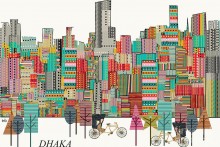
In the past, many travelers visited Dhaka and their visual accounts are considered as an important tangible evidence of Dhaka’s History. Art works by Sir Charles D’Oyly, Frederick William and George Chinnery, who visited Dhaka around 1st half of the 19th Century, help us to reveal city’s past imagery. Even today, we mesmerize to see the photographs of their etching, paintings and sketches of historical Dhaka. The aim of this article is not to resurface those images again. We rather were keen to learn how present Dhaka is perceived and portrayed by the foreigners who traveled to Dhaka or somehow experienced the city recently.
Our source is obviously the internet. We’ve collected the published illustrations from personal blogs or social accounts, official sites and other online sources. Among the selected illustrations, sketches from Architect & Author Francis D K Ching and Australian Architect David Holm are also presented.
Dhaka_The Traffic Capital
Dhaka often labeled with ‘the traffic capital of the world’ offers to the artist nothing but the image of City’s gridlock traffic perhaps. Illustration by Google Doodler Sophia Foster-Dimino, Painter Christopher Corr (UK), Marlene Nobel Keramiek ( Netherlands) is not an exception but unique in their own style. Sophia’s illustration on Dhaka traffic was first published in New Republic on July 3, 2014.
In February 2015, after releasing Google street view of Dhaka, a group of Artist published their artworks on Dhaka and Chittagong city on the website called virtual paint out. The site is hosted by – Bill Guffey, (a self-taught artist living in Kentucky) where an artist uses an image found through Google Street View as the reference for the painting or drawing. Most of their artworks framed the informality of Dhaka where Rickshaw was a common subject matter.
The author of ‘Form, Space & Order’ – architect Francis D K Ching visited Dhaka in Jan 2016 to attend the 10th-anniversary program of Architecture Dept, AIUB. He drew two sketches on Dhaka street and later posted them on his blog Seeing.Thinking.Drawing. According to him “I drew this view to record a recurring sight along the streets of Dhaka, the large bundles of cables and wiring that carry electricity and communications to buildings”. While explaining his sketch on Shakhari Bazar lane in Old Dhaka, he also noted “It’s interesting to compare the street views of Taipei with two I drew in Dhaka. In contrast to the relative orderliness of Taipei, we have the ‘informality’ of Dhaka. But as one Bangladeshi told me: “Within the informal, there is the formal.”
Australian architect David Holm, director of COX architecture and Churchill fellow, visited Dhaka in Sept 2015 for the purpose of a workshop on drawing and recording the public spaces of the city. During his stay in Dhaka, he drew several sketches which he posted on his Twitter account. His free-hand quick sketches nicely framed the public space and architectural heritage of Dhaka.
The mega city Dhaka is growing rapidly, but its rather focused on quantitative growth than on qualitative aspects in terms of physical urban environment. However, it needs to be reviewed and improve the quality of the physical urban environment. Several projects are already underway as people’s interest in improving the quality and pleasantness of urban environment is rising these days.
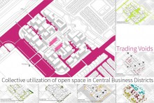
Our development pace in the city areas is really high. Dhaka is a growing city with only 0.006 hector land per capita. With this shortage of land and resources, we need to go through a collective process of development. We should share space, share resources. Whereas the planning, resource allocation, land division going for more and more nanoscale. Plots are divided as private property. Where rules and regulations bind us to use only somewhere around 50% percent of owned land. But the leftover space is almost of no use or better to say no utilization. It is causing many social and urban problems such as bad work environment for the employees , traffic jam, lack of recreational facilities, unplanned temporary structure etc. it’s the worst scenario in the business areas such as Motijheel or some parts of Karwanbazar.
Central Business District is the commercial and business center of a city. In larger cities, it is often synonymous with the city’s “financial district”. A city’s CBD is usually typified by a concentration of retail and office buildings. The CBD usually has an urban density higher than the surrounding districts of the city and is often the location of the tallest buildings in the city.
Through a methodological study of the CBDs of Dhaka (such as Motijheel or Karwanbajar), some basic problems can be identified. Incompatible co-existence of the office building and pedestrian facilities, on street trading all these resulting in traffic congestion, lack of sufficient parking, illegal occupancy, noise from the roadway. Again, the absence of recreational area, adequate food shop turns these CBDs into a place which one wants to leave as early as possible. Whereas a CBD amongst all the developments in a city has the highest scope to contribute to the urban realm.
So the question arises, how the diverse contextual possibilities of urban facilities can be integrated within a rapidly growing central business district ?
Consideration and process
What is trading and what are the voids ?
Trade, or commerce, involves the transfer of the ownership of goods or services, from one person or entity to another, in exchange for remuneration, goods or services.
Here trading refers to the exchange of open spaces between public and private ownership for better utilization. Public owned open spaces consist of i) roads ii) footpaths etc while private owned open spaces consist of i) mandatory open spaces ii) setbacks for buildings. The exchange of such open spaces facilitates both private and public sectors by ensuring proper distribution of open spaces in both sectors.
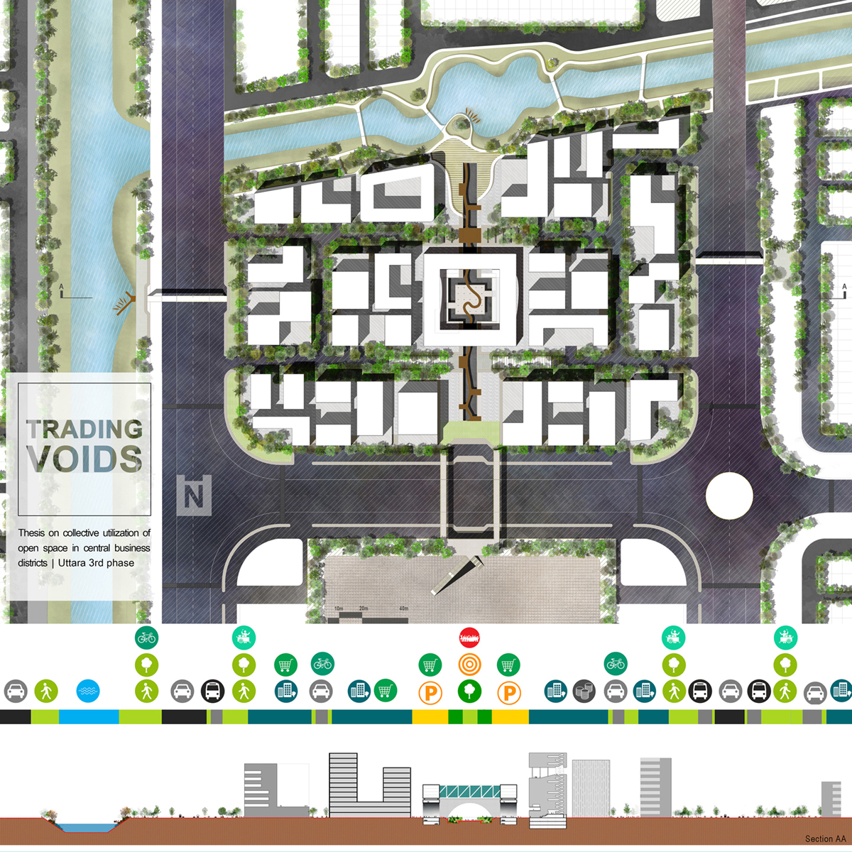
Uttara 3rd phase is a highly anticipated and one of the most ambitious projects of the government. And it is a project of high concern of our country. It includes a 40 acre CBD in the center. It is where the work of metro rail is going to start from. So in near future, it will be a really well-connected place of the capital.
Several possible arrangements of plots are determined. The optimum plot arrangement to be derived by doing a comparative analysis on the basis of factors like,
– Road optimization
– The amount of open space
– Visual connectivity of the open spaces
– Mass movement
– Wind flow etc.
Here it is observed that in a smaller plot arrangement the most connected open spaces are in between two buildings which are mostly unutilized or remain unused. In terms of human usage and the wind flow it performs very poor. So this is clearly a bad arrangement. But, when we gradually increase the plot size and break the gridiron pattern we get good results in connectivity and wind flow as well. The well-connected patches are more on the front sides of the structures rather than the spaces in-between the buildings. Moreover, the in-between building open spaces are minimized in a high rate.
We may come to a realization that, The open spaces are just right there, just haven’t been noticed yet.
From the analysis, it is concluded to some general decisions for Central Business Districts of future.
Maximum Size of a CBD should be 50 acres
Minimum Plot size 2500sqm
Minimum Road network is appreciated and it shouldn’t exceed 20% of the total site.
The vehicular and pedestrian access to the site should be in different axis
The plots in the same ribbon should be accessed from the same edge, the alternative edge should remain for uninterrupted pedestrian movement and can be used as a commercial interface such as shaded shopping lanes.
It s proposed that there will be a Central Business District Management Authority (CBDMA), which will be liable for quality maintenance of all these open spaces and they will enjoy the revenue produced from these spaces as well. The function of this central body may vary with the context. It will be a commercial entity itself.
Possible Programs
Hotel
Market
Amusement etc
It may not require any structure also and the programs can be replaced by some activities. This will enhance the open space quality.
These decisions are applied to the site with some basic site-specific considerations keeping in mind. Like, reviving the water edge, creating a central zone followed by a central spine. In that purpose, the basic function of CBDMA is considered as a marketplace and cinema complex which will equally generate economy and maintain the total open space. The mass is lifted up with arch structures creating a visually connected open space.
but when we run the human agent analysis we see a crowding at the central zone. So an interruption in the movement creating a restful recess place at the center. This leads to a possible master plan of the whole CBD which ensures the total required built area but still adds some values, unlike the previous situation.
Functional Values
The Road network is minimized to about 50% and the canceled road alongside the lake allowing the water transit to be utilized properly. below the central mass, a central parking can be accommodated which may serve 24 hours need and many guest parking.
Social Values
Different interaction points can be created for social exchange. The huge uninterrupted pedestrian movement allows casual movement for social interaction. Beside social welfare for the underprivileged can be assured by many employment opportunities.
Economic Values
Overall the quality environment creating a huge economic rise to the spaces beside many shopping lanes and 24 hours open portion generating economy.
Environmental Values
Five types of environmental steps should be taken.
1 _ Island : a Continuous island with shading and fruiting trees.
2 _ Chunk of green : Huge 25to30 feet wide green chunks contributing to soakable ground and remains as a contained green space.
3 _ Perforated Plaza: Pedestrian plaza perforated contributing to soakable ground.
4 _ Aquatic vegetation : Sunken vegetation along the central spine with a rich CO2 sink and dust catcher shrub family.
5 _ Water edge: Bangladeshi natural water edge can be revived with the indigenous plant community.