What do we seek in a forest? What do we look for in a site situated in the middle of the forest? Who will be the visitors? Interests? What do they hunt for?
To commence the brain storming for this project, several ‘CONCERN’ were taken into account instead of a single ‘CONCEPT’ merely based on hypothesis.
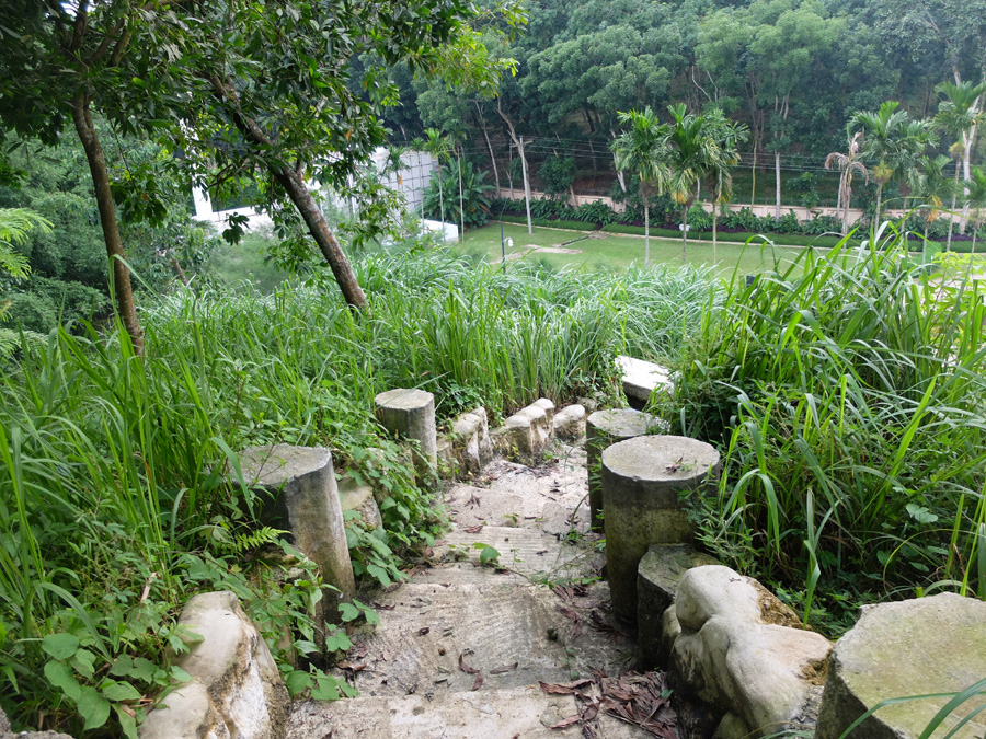
Concerning the location in the midst of Bhawal National Forest consist of Shal trees and the presence of buildings/ structures on the site obligated us not to propose any groundless vertical elements which might hamper the ambiance of the forest except proposed local trees or six low height sculptures or street light posts. Keeping this fact in mind, not a single tree had been cut during construction.
From the beginning of the brain storming ‘use of material’ was the key concern for design team. In the case of material selection, the use of polished marble, plastered wall, shiny materials were avoided deliberately to retain the essence of the existing natural setting and exposed brick and concrete were used instead.
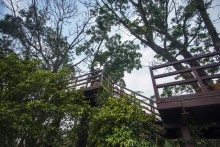
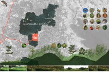
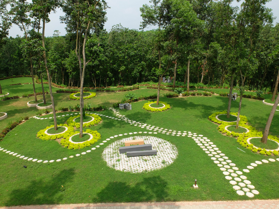
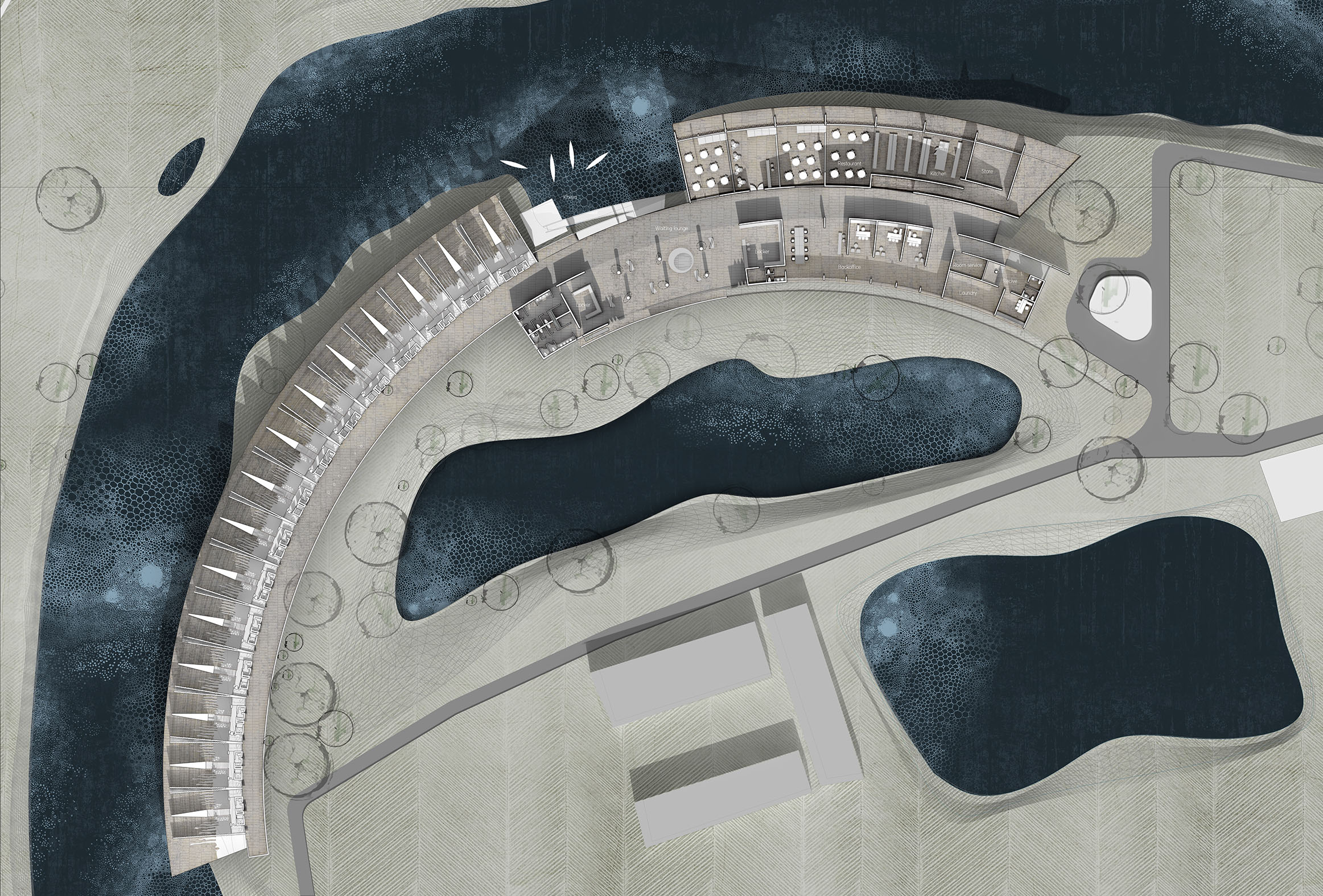
Landscape plan, BRAC -CDM compound, Rajendrapur
The position of the buildings/ structures are situated in a scattered manner that divide the entire site into unconnected chunk of spaces. Proposed new road network along with the bicycle route and walkways helped to connect the isolated spaces and gave them identity as Individual Island for sole performance. Each Island was named based on the theme of that certain space and its functions:
আঙিনা / Courtyard
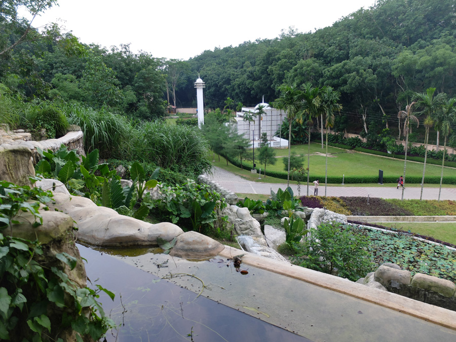
After crossing the main gate, there is a plinth over a semi-basement parking located on the southeast corner of the site accessible from a plaza at west and a staircase with ramp from the north. As the training centre welcomes different age groups from remote area to corporate officials, we thought this plinth could be used as gathering space, therefore named, Anggina or Courtyard. Provisions for large scaled Chess and Ludo provided along with seating and sports spaces like a mini football ground.
Next to Anggina, there is the butterfly garden with a gentle play of land undulation. When we first came to visit the site, we saw various butterflies wondering in that certain territory. We decided to intensify the provision even more and set up a garden and a butterfly nest.
Solar bricks are used to lit the garden pathway at night and to enhance the visual comfort and set the environment pleasant and relaxing for the visitors who will be staying overnight in the hostels after long day training.
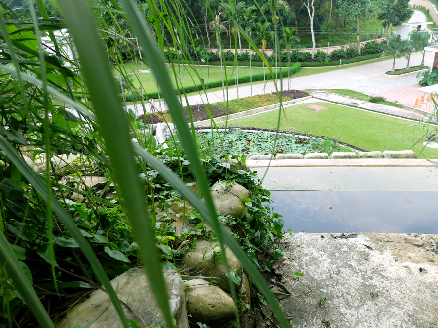
Potibimbo is a large pond located opposite to the plaza of Anggina. Apart from the fishing decks we have provided two more ghats/ platforms on east and west side. The Ghat situated in the east is named as সূর্যাস্তেরঘাট/ platform of sunset where visitors can sit, relax, enjoy the sunset while merging their legs into water. A regular ghat on west is called সূর্যোদয়েরঘাট/ platform for experiencing sunrise.
সূর্যোদয়ের ঘাট ( platform for experiencing the sunrise , BRAC CDM, Rajendrapurসূর্যাস্তের ঘাট ( platform for experiencing the sunset , BRAC CDM, RajendrapurFishing Deck , BRAC CDM, Rajendrapur
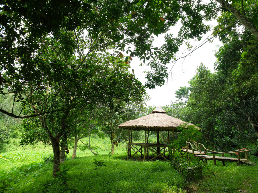
তরুদ্যান/Forest
Advancing more to the North West corner of the site, behind the gymnasium and water tank, anopen fieldwere shaped and kept as it is purposely wherein multiple functions can be hold when needed i.e. fair, open to sky ceremonies, play field etc.
In the west of the field, utilizing the number of existing 20 Mehogani trees, a Toruddan or a grove/miniscale forest was proposed with new indigenous trees[flowering trees, fruit trees, forest trees, medicinal plants along with various shrubs] in order to set a place as a good learning space for next generation where they can embrace nature.
গাছ বারান্দা ( Tree Terrace) , BRAC- CDM, Rajendrapurগাছ বারান্দা ( Tree Terrace) , BRAC- CDM, Rajendrapur
Employing two Mehogoni trees, a two layered গাছবারান্দা/ tree terrace acting as a watch tower where visitors can experience the open field at one side and a children’s play zone opposite to that. The play zone offers regular playing instruments,considers physically and mentally challenged children as well. The place is intentionally kept slightlyundulating for children to experience the different elevation of nature. A mage made of different types of shrubs with a spiral staircase is located there to make the place more interesting and mystical for children.
প্রেরণা/ Inspiration
A sculpture garden named Prerona was proposed on the north eastern side of the site near another pond with the concept of representing the philosophy of BRAC as an institute. Later, six sculptures are distributed in different location of the site.
Showing respect to the site and nature, not a single tree was taken down during construction. The roof of the waiting area at the left side of main entrance gate was edited and excised to save the mature trees. Thuja trees which were located both side along the entry road, blocking the vista of the site not being cut but replanted in another suitable places. Above all, most of the proposed trees in the site were native.
Night view of the compound ,BRAC CDM, Rajendrapur
Major obstacles
Though legal legislation is not being implemented by Government, it was hard to find Landscape standard for Bangladesh. Obviously there is a lack of research material. We tried to find some rare species to plant in Toruddan, but failed. Choices of plants to collect or purchase from nurseries or even from Boldha garden and Botanical garden are really limited. Now a days landscape Architecture is a flourishing discipline in Bangladesh, we need to have a common platform to share information and a forum to set standards. The perception and patience of the client regarding landscape projects and its related time period to achieve the real scenario is also an issue.
Project Team:
Landscape Architect: Syeda Tuhin Ara Karim
Architect: A S M Kamrul Islam Shatil
Junior Architects: Amit Kumar Bhowmik, Masum Un Nabi,
This project was nominated for Archiprix(2017) International Hunter Douglas Award. This is the first nomination ever for Bangladesh. The project’s model was selected for re-making as a part of CEPT’s Summer Winter school’s model making course “RETHINKING MODELS” and was later exhibited. Earlier, the project made the long list of 50 Best Projects of Tamayouz International Award 2016.
Think, in near future there is no source of power. No furnace oil, no gas to produce electricity. Resources of our planet is decreasing at an alarming rate. We have to think about the future how can we live with the limited resources available. What if we can integrate numerous functions in a centralized infrastructure. What if architectural solutions come forward to eliminate the barriers.
In response to power crisis and water crisis in south east part of our country Bangladesh, we need to find alternative ways to produce renewable energy. A number of feasibility studies made in the 1980s and in 2014 which have the potential for setting mini-small hydropower stations of 10 kW to 30MW capacity.
What if these hydrological structures are integrated with the society and nature, what if they are inhabitable and act like one small village, one breathing hydrological infrastructure? My proposal is that a prototypical hydrological infrastructure which not only generates power but also connected with society. A dam that holds the society. Current models of dam comprises the problems including, : dislocation, segregation and over imposition into its context, service specialization and ownership, and single-mindedness of aesthetic and function.
For these reasons, my proposal of searching for a Breathing Dam is towards a new typology of hydrological infrastructure – away from the image of hydrological infrastructures, and towards a model which is not only connected but also integrated with society, to create archology which may help alter the public perception of the essential infrastructures and reduce many of the negative consequences associated with infrastructure management. Also eliminate the flash flood and water crisis of the hill tracts.
This dam will provide them with the scope for better agriculture and water management system. And the power will help them to make a self sufficient village. Together, with the integration of ecology, society and infrastructure, the breathing Dam will become a prototype of a modern ‘hydraulic empire’.
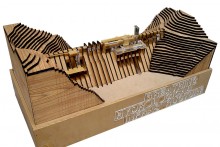
The site is located in Dochori Bazaar ghat, Alikadam, Bandarban which is an Area of 34 acre. But project footprint is 4 acre. Ministry of power, mineral and energy along with an American organization analyzed few sites in south eastern corner of Bangladesh. The proposed site is designated as j17.
Around the world flat plate buttress dams are used as a cost effective, high capacity and durable structure system to hold hydrological structures. It can reach a height above 640′. So for this, The project of 170′ inhabitable infrastructure would do easily in our context. This type of dams are very efficient where the ground soil is not that strong. For this project Flat plate buttress dam is selected for its construction efficiency and cost efficiency.
Preliminary study models are to explore the structure pattern and how the infrastructure is going to integrate with the contours. In order to understand the complexity of the project there is a need of understanding the structure & zoning of programs integrated with the whole structure; connected by multiple layers of circulation. The diagram illustrates how the structure is ordered and how different zones are integrated within the flat plate buttress dam.
Program generating for the breathing infrastructure came from solving the existing problem and limitations. Women’s are proactive in their society though they are deprived. Health care facility almost rare in the context. There is no scope for ethnic craft showcasing. Electricity is almost a dream for the families. From the above problems and situation I have concluded to 4 major program. 1. Women’s opportunity Centre 2. Health care facility 3. Power station 4. Residential facility.
The hydrological breathing unit will serve as dwelling for people. women’s opportunity centre will be the hub for women empowerment. Health care facility will improve the health condition of the region. This centre will showcase and celebrate the ethnic culture. Hydro electric power plant will produce power for 5000 families. Dam will create hydrological resource for drinking, irrigation and water based transportation. the dam will house one permanent elementary school and one local market.
My strategy was to conceive a policy to train and integrate local people to come to that facility and get benefited. Through women empowerment this place will work as a hub for women. This facility will serve as centre for opportunity, primary education hub and power supply for the regional families.
This design is an inverted kind of design. Spaces will be contained in itself. But in some extent it will be expressive. Spaces are designed as it can provide enclosure in between the structure. The design is inspired from the solidity of hills and their character. The whole buttress dam is integrated with the hill and the architecture is integrated with structure. Structure reveals architecture then it becomes spaces.
For this kind of unique project the plan does not come from the bottom to be understood but from the top of the dam where all the story begins. The upstream water is high and the downstream is low. All the functions are facing toward the southern downstream, so air ventilation and the light throughout the day is easily penetrate the inner spaces.
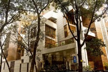
Dhaka, one of the most densely populated cities in the world, where most of the single family residential buildings with open green spaces are continuously disappearing day by day. Multistoried apartment buildings are replacing the low rise individual houses to cope with growing land price and ever increasing housing demand. This phenomenon is transforming the residential morphology of the city at large. Only in few plots in upper-class neighborhoods of the city single family houses are still evident. Residence for Khan’s family is one of such exclusive examples.
HR Khan Residence is a single family residence located at Banani, a planned residential area of Dhaka. This is a corner plot connecting roads at the northwest and southwest. The northwest road has median with large Rain trees acting as a screen providing privacy for the house. On east and north sides there are ten storied apartments with façades having 54 windows peeping over the plot is a challenge in terms of privacy. To ensure winter sun and summer cross ventilation for the living spaces, which is very critical, pose further challenge as the land has its exposure form northwest and southwest corner only.
The play of nature with green field and the flowing water containing the basic archetype of Bengal delta. In this region, the courtyard is a traditional typology creating space for living in privacy along with cross ventilation, ample daylight and vegetation. The effort was further to achieve a traditional living ambiance with layers of greenery to achieve a deltaic condition. The green terraces in different levels have intentionally been split so that we can bring the formal living, family living, dining spaces along with the terrace which is a metamorphic representation of our traditional courtyard.
It’s an irony that the more we are being developed, the more we are losing our resources. Humans have achieved the tag of ‘planet wrecker’ for their selfish act of ignoring his environment by throwing off rubbish which ends up in landfill site. Our response to the query whether ‘rubbish’ is a refuge or resource is largely inconclusive and so is our waste management system. In many cities, use of landfill sites for disposal of municipal waste is very common. Dhaka is not an exception. Though, Dhaka recently adopted a Solid Waste Master Plan, sufficient waste collection services are not available in most areas of the city. Only 40–60% of Dhaka’s waste is collected and transported to the city’s two landfills at Matuail and Ameen Bazar. Nobody knows what would happen to the sites when entire site is filled against continuously generating waste. In structural plan 2016-2035, recommendation has given towards 3R strategies (Reduce, Reuse and Recycle) of waste management instead of land fill.
3R strategy comprising reduce, reuse and recycle has become the universal law of good consumption. But does it really work? The terms reduce and reuse come with compromise but who would compromise or why should one compromise? Again, after industrial revolution a series of products have been launched to the planet with a tag of ‘warranty’. So it won’t be wrong to say that the products of today are designed to be landfilled so that consumption can continue. Recycling rather sounds more practical option where the main idea is to recover. If we see in nature it is growing then breaking down and re-growing; the most perfect recycling and re-using system has always occurred in nature, then why not us?
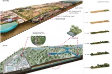
In the big picture, the scope of the following project involves re-thinking of the waste management system through the process of recycling which is independent of landfills. This will create opportunity to heal the existing dumping site and re-claim the lost urban open space (proposed on DAP 2015). The project proposes re-generative landscape (phyto-capping) as a mechanism to heal the existing by reducing toxicity of the land in a gradual way, so that the reclaimed healthy open ground can serve the surrounding neighborhood. In addition, a waste treatment plant is proposed to recycle both the biodegradable and non biodegradable waste so that nothing is left without recycled.
While designing the internal circulation of the urban park, the main challenge was to create shortest possible and efficient connection between nodes and internal facilities. The site was surrounded by roads on all four sides. So there is highest possibility that traffic flow will occur from the road junction. With the help of algorithm in Rhinoceros, Grasshopper, shortest possible connection within points were simulated on the basis of four parameters, i.e. i) Nearest node point ii)Speed iii) Attraction point iv) People flow amount . After optimization of the results a final circulation paths were obtained which satisfied all the requirements.
Other proposed facilities include Zero Waste Research Institute, community and sports facility and activity kiosks. The zero waste research institutes will promote research and conduct social campaign to build awareness on waste management and to seek efficient way to process waste in future. This park is surrounded by various localities, so community facilities and sports facilities with a mini open field is necessary for them. So a facility was designed which is visually permeable and made of celluloid structures. Every cell consists of different functions with a provision for future expansion. Along the circulation paths activity kiosks are designed so that people can take rest or relax while moving through the park from one place to another. Most importantly these kiosks will be made from recycled materials designed by zero waste research institutes.
The Palace Luxury Resort and Spa is located amidst remarkable and scenic landscapes surrounded by Rupaichara rubber forest, the Brindaban tea Estate as well as BaiccaBeel, Hail haor, which is one of the ecologically vibrant zone of Bangladesh. Located 70km from the city center, the site is strategically tucked away from urban chaos in an isolated plateau.
Existing landscape of the resort was a mixture of monoculture, like the rubber forest, tea garden and some open grassland with forest patches and shrubs that required huge labor and high maintenance. Landscaping around the guesthouses were largely done with unplanned non-native species and clusters of large trees grown for aesthetics only.The site had immense potential, however, improper species distribution, intensive monoculture practices and needless landscape features segregated the site.
Some remarkable areas with varieties of trees and numerous shrubs were seen on the North of the site only where local birds mostly gathered compared to other areas. Our walkthrough hardly showed diversity of mammals but we observed presence of Raptors, such as Shikra and Crested serpent eagle and numerous Spangled Drongo in those forest patches.
Located on terraced slopes, Rupaichara rubber forest, an old monoculture of the site is more of a disadvantage as it is non-native.Faunas and mammals that depend on rubber tree are very low. The nature of rubber species is such that, it absorbs moisture, dehydrating the soil, making it loose and prone to erosion as well as causing springs and valleys downstream to go dry. This monoculture was allowed to grow by trimming of any vegetation that naturally grew underneath and lack of knowledge resulted in an empty forest devoid of species.
Despite being a monoculture tea garden had visibly more species diversity than rubber forest; we observed plant species like Chapalish, Mandar and Jackfruit scattered all over and spotted only mammal Capped Langur as well as foxes.Due to local’s dependence on native plant species for wood, logs, Beetle, medicinal plants and construction materials the tea garden was more diverse.Local settlements along the periphery of the tea garden was a preying ground for raptors.
The-palace_GOAAT_context-05
The-palace_GOAAT_context-06
The-palace_GOAAT_context-07
The-palace_GOAAT_context-08
The-palace_GOAAT_context-09
Our study of species distribution for both plant and animal helped identify areas that interfered with wildlife and provided zero ecosystem services.The landscape design we proposed was imagined as a“closed-loop” system that is self-sufficient, not imposed or borrowed yet inclusive for wildlife.Our concept of any landscape solution comes from the understanding of the sensitivity of the context and its interrelation with the existing biota. Walking through the site we identified critical spots and loose ends where thoughtful ecological engineering could integrate the landscape for a “closed loop” zero waste system using handpicked native species for a performative landscape.
Our main approach involved regenerating deforested spaces, establishing physical connections by creating natural corridors and pockets with key species to ensure natural sprawl, movement and habitat growth while also minimizing conflict between wildlife and tourist. Ecological engineering in key spots ensured a natural self-sustaining, low maintenance system with dedicated routes for tourists as well as wildlife.
The landscape proposal was implemented in phases and we started off by restoring the rubber forest to protect the local water resources and the existing biota. Rubber forest had to be deforested gradually, layer by layer and reforested with 150 varieties of about 100,000 species.Fifteen types of native bamboo species and carefully selected trees were planted around the springs to regenerate them and increase the water retaining capacity of the soil which is crucial to maintain the natural water resources.
To ensure a closed loop zero waste system, the logs were reused as retaining walls in various locations .Seven types of Ficus was planted every 50 feet as a host plant for other species to promote the propagation through birds.
Major access routes and unsafe openings were protected with soft, permeable boundary using heavy foliage, fast growing and fragrant species instead of using rough fencing or any artificial element that could interrupt wildlife movement.
Tree lined avenues were proposed at major locations to create multiple atmosphere with seasonal variety of colors, varied fragrance of colorful flowers and foliage to improve the air quality, create visual stimuli and overall ambiance of the site. Landscaped spots at alternative locations with shrubs, nectar based and fruit based plants helped attract local birds and butterflies.
A visually obstructive and high retaining wall at the entrance of the resort was replaced with an artificial waterfall of 10,000 square feet using aquatic vegetation collected from the local Haor that turned out to be interaction point for human, birds and wildlife.
Trekking routes, natural pathways, resting spots and bamboo bridges were minor interventions to the site with the help of local labor. Our strategy to use native species only that were handpicked from the site and surroundings, addition of host plants at prime spots creating suitable habitats dramatically turned around the landscape into an active ecosystem that reciprocates with its Biota.
Before /After
PROJECT DETAILS
Project: Ecological Restoration and Landscape Design of “The Palace” Luxury Resort and Spa
Internationally acclaimed Architect Md. Rafiq Azam representing his Dhaka based Practice SHATOTTO has won the CITYSCAPE AWARD 2017 for “South Huda’s Skyline” project. The honor has been announced on 11TH September, 2017 on a grand Award Gala Night at Hotel Conrad Dubai, Dubai. The Cityscape Awards for Emerging Markets celebrates excellence in real estate development and architecture. Covering a range of categories, the awards offer international architects and leading real estate developers a prestigious platform to communicate a shared vision for the future, from culturally integrated city skylines to sustainable urban communities. SHATOTTO has been declared as the winner under the category “Residential- Medium to High Rise (Built)”. The developer of the project is “South Breeze Housing Ltd.”
This year over 300 submissions was received from 13 different countries of the world in 11 different categories, and only 45 shortlisted by an independent panel of experts and invited to present their works physically in front of the Jurors on 9th September 2017. The jury panel then selected the winners and it was announced on 11th September 2017 at DUBAI on one of the biggest real estate event Cityscape Global 2017.
The project “Huda’s Skyline” is a Joint Venture (Landowner and Developer) apartment building development in Gulshan area, a high-end residential area of Dhaka. Here the land area is 803 square meter and the number of apartments are 23, means the density is 114 units/acre. The challenge of the project had two folds. One is achieving the maximum construction area in order to make the development viable both for developer and landowner. The second challenge was to make the development a construction in terms of social and urban landscape. Architecturally the project was quite an interesting and challenging since it was a corner plot facing East & North. The north is also facing a large mosque with a green open space along with some large trees. So the lack of sun light except early morning on the East was a big design consideration in this project. In order to justify the climate and context, a “L” shaped configuration of the building has been considered, which generated a green lawn in the corners of the street. So the existing mosque green along with newly developed apartment green created a new urban landscape as a contribution to the city. Furthermore, the glass boundary wall has been used to enhance the respectful and trustful relationship with the citizens of the city. It is very clear that the high solid boundary wall with barbed wire and “be aware of dog” sign is a symbol of disrespect and distrust among the community.
The ground floor has been designed in a way that it becomes an extended landscape of the city and a rendezvous place for the apartment owners. The double height entrance has been created not only to ensure the ground floor lofty entry but also allowing the inclined winter sun touches the lawn in the morning. The use of lofty glazed lounge, the water body, the lawn all visually connected to the community philosophically making the building a social phenomenon. Since Dhaka is a high seismic risk zone, the building has been reduced its volume as its goes up. Hence, generated numbers of terraces and gardens with duplexes and pent houses. Use of exposed reinforced concrete structures with infill exposed terracotta brick not only justify the earthquake resistance but also justify the subtropical architectural poetry.
From the dawn of its emergence, Semarang, Indonesia has been continuously challenged by various natural disasters throughout the decades. The intensities and modes of calamities have changed with time, but the stress remains the same. However, the inhabitants of this area have still now managed to survive despite having provided all possible difficulties by nature. This thriving attitude of the inhabitants is what we feel the greatest strength of this project. With the advancement of technology, better and innovative infrastructural solutions can be provided to stop the disasters every now and then, but until and unless the society is ready to accept and adopt it, every effort will eventually fail.
In our proposal, we opt to build a Soakable Society -a society that can withstand whatever natural disaster it is challenged with and is ready to soak up the shock and stresses. We have explored how architecture can contribute not just to ensuring a stable house, but also to nurture a self-sufficient and secured family. We have generated and triggered those scopes for attaining social and economic resiliency, through urban and architectural decisions. The society itself will in the process eventually address the factors causing the disasters and their approaches towards a resilient community will ensure the better living condition of the concerned inhabitants.
Urban space including a mosque, market and water retention areas will act as the cultural and economic hub of the culinary village
COMPETITION SITE: KAMPUNG KALI BAHRU, INDONESIA
The site is located in the Kelurahan Bandarharjo on the northern part of Semarang. The site is defined by very clear boundaries. To the north the area it is limited by Jalan RE. Martadinata, the primary arterial road connecting the western and eastern parts of Semarang that also connects to the airport. The west boundary is formed by Jalan Lodan Raya and Kali Semarang, the Semarang River, and the east boundary by Jalan Yos Sudarso and the Kalibaru, the New Canal.
Reclaimed Neighborhood and Topography: Although Kelurahan Bandarharjo sits on the lowland reclaimed from the sea and can be considered almost as flat, the site is characterized by a micro topography. In this sense, the central part of the competition site is slightly above the level of the areas close to the canals.
Economy and activities in the neighborhood: The port area of Tanjung Mas Semarang is located next to the site. As an area neighboring the Port, the site has always been closely connected to the harbor in terms of activities and work dependence. Proof of it are the existing warehouses located north of the site.About a third of the population living in the area are dependent on some kind of manufacturing or industrial activity for their livelihood.
In addition to these activities, small local shops with local activities can be found scattered around the neighborhood. It is notable that in the northwest part of the neighborhood, beside the Semarang River, a large amount of houses and families have developed a smoke fish cluster. These families cook and smoke fish at home and sell it in the market.
Heritage:The “Goedang Toedjoe” warehouse (1911) is the most important heritage element in the area, and it has been designated as a listed historical building.
Semarang at a glance: typical ‘smoke fish’ neighborhood, the Goedang Toedjoe warehouse and flood in 2016
Environmental problems in the area: Droughts, Subsidence, Flooding
The combination of demographic and environmental characteristics makes the SMA and the competition area a particularly important site for examining local vulnerabilities and adaptability to climate change.
Droughts and lack of water infrastructure: One of the main environmental issues affecting the city of Semarang are droughts, and Kampung Kali Bahru is also under this risk. This issue, coupled with the lack of water supply infrastructure in the neighborhood has led to the proliferation of wells and the over-exploitation of the ground waters. As a result, the space left by sweet water is being replaced by sea water (sea water incursion), with the consequent salinization of the ground waters and the decrease of their quality.
Subsidence: As a consequence of this excessive use of the freatic levels and intensive development, the effects of subsidence are affecting the lower area where Kampung Kali Bahru is located with the soil sinking between 5 to 8 cm a year.
Flooding: Land subsidence increases the impact of floods. There are two types of flood that occur in Semarang, i.e. the tidal flood which is caused by, among others, the increase of seawater level and land subsidence , and flash flood. There are 21 rivers located in Semarang, creating a high risk of flash flood. Flash flood is also caused by poor drainage infrastructure, environmental degradation in the upstream area, sedimentation in the downstream area and high precipitation.
Sea level rise is estimated at around 15.5 cm by 2030. However, land subsidence has a greater impact to the community. It reached 13 cm annually in 2015 and this means that tidal flood would affect around 300,000 people who inhabit the coastal area of Semarang, including the neighbors in Kampung Kali Bahru. Unfortunately, the residents in coastal communities who mainly work as factory workers and fishermen cannot do much, and they basically try to adapt their houses to be higher than ground surface, while some others simply see the flood as a part of normal life considering it happens so often. (100RC, 2016)
Communal waste management also contributes to flood disasters. Flash flood and tidal flood are related to the community’s poor attitude towards the environment, such as littering. In Semarang, 50% of the total population was not covered by the municipal government’s waste management service especially in the slum kampung areas, where the low income and vulnerable people live.
The entire design process for achieving a soakable society is categorized into two broad sections- Urban resiliency and Socio-economic resiliency. Soakable society is proposed to be a conglomeration of the cyclic efforts in each of the sectors.
Urban resiliency
Broader urban decisions are proposed in order to ensure a level of protection from the ongoing hazards in the long run. The major sectors considered here are
i) Rethinking Landuse: The existing landuse shows a very scattered distribution of houses, with no space for recreation and community activities. In the existing settlement many houses are found to be already in an unlivable state, due to land subsidence and flooding. This type of houses are proposed to be cleared, and in the combined land of two to three houses each, a shared landuse with new module of house is proposed. This will also make window for some pocket green spaces which will act as the soakable retention spaces during heavy rain or flood.
At the starting of the project, few houses can be built with the assistance of the government and NGO’s which will set an example to the inhabitants of the better option. Eventually when they will be able economically (as described afterwards) they can follow the previous examples and contribute themselves to upgrade their own houses.
Besides, a new housing settlement is proposed in the site where the land is comparatively more vulnerable and most of the houses and destroyed by land subsidence. This new housing area will provide a model for housing cluster to be followed in the future, when rebuilding the existing houses will be feasible.
Proposed water retention zones in low lying areas and the green network will form a layer of social spaces ensuring utmost soakability of the land
House module: As for the house module, the connected plinth is retrofitted to the existing houses. And new housing modules are designed so as to withstand the socks of disasters like Flood, Storm, Earthquake, Land subsidence, etc. A pre-fabricated structure is proposed which can be easily assemble o site. The steel framed structure with cross bracing can be effective in cases of storm ad flood. Foundation is proposed with tyre and gravel, which will reduce the weight of the total structure and the hassle of concrete construction can be avoided, assuring maximum soakable earth without the damage caused by construction. The filler material is proposed to be either bamboo or coconut brick as per user’s preference and affordability. The choice of coconut brick is because it is light weight, the pressure upon land and thereby subsidence can be reduced, and due to its fibrous nature, minimum damage will be cause in cases of earthquake. The roof forms are also chosen keeping in mind the stress of storms upon a house module.
The new houses are proposed on stilts so that maximum soakable land can be preserved
ii) Mobility and Accessibility: In case of assuring resiliency for a site, a well-connected road and transport network is very essential. Considering the current situation, two public bus loops with a bus station and connecting bus stops are proposed. This will provide a direct public transport facility connecting Kampung Kali Bahru to the nearest railway station “St. Besar Semarang Poncol”and Kota Lama, a nearby flourished city. This will not only ensure the smooth communication of the village to central Semarang, but also will improve the administrative status of the Kampung, eventually attracting tourists and researchers to give attention to the site.
In micro level the roads are redefined and segregated for better connectivity. With respect to hierarchy, the roads within the site are categorized into Arterial, Major Collector, Minor Collector and neighborhood roads. This segregation will also help maintain the variation of privacy required in different layers of roads. For example the homely flavor of the neighborhood roads and the busy cacophony of the arterial roads are not desirable to be overlapped.
iii) Ecological infrastructure : As the site is oriented very close to the sea coast, broad scale protection of mangrove layer is a must. Regeneration of mangrove is therefore proposed along the sea coast on both sides of the port. This will reduce the intensity of flood and storm to a major level. Besides, mangrove actively contributes to restoring land to the shore, thereby curing land subsidence.
The low lying areas within the site (which are prone to inundation) are suitably proposed to be water retention zones, which will parallely act as urban community spaces. These zones are the termination of the scattered pocket green spaces proposed within the housing chunks. Thus the entire green network will develop a layer of social spaces ensuring utmost soakability of the land.
The existing box culvert in the northern side of the site is proposed to be reopened as a canal making complete circuit of water connection enwrapping the village. The internal drains and bioswales will combinedly drain out the flood water to these canals. Besides, for the gray water drainage lines, backflush valves are proposed to be installed, so that during flood, the dirty water does not overflow and pollute the environment.
Socio-economic resiliency
Let’s imagine a situation where a village is provided with all the high-tech utilities to fight a disaster. But neither can he afford them, nor does he have a close connection with his neighbors who will stand by his side in hard times. Eventually all the measures will go in vain. This is where the inevitable necessity of socio-economic resiliency comes. The basic target is to make a society culturally bonded and economically solvent enough to face any unwanted challenge.
As already stated, the entire village is proposed to be a thematic culinary village. The scopes for social interaction and economic platform are provided in two levels: Neighborhood and Community.
i) Neighborhood: The neighborhood roads are the roads just in front of the houses. These roads hold a very intimate sense of space and are used by the villagers for various daily activities. Unfortunately during flood, these roads become a source of hazard, imprisoning an inhabitant to his house. Intervention is proposed in the construction of this road as shown in the figure following, so that they can hold the flood water for the time being, until it drains out entirely. The plinths of the existing houses are retrofitted to make a connected passage way during flood. This plinth will perform as the primary space for production of home based goods for sale, and maintain a well-communicated neighborhood as well. This series of connected plinths meet up at the pocket green space of the specific chunk, alongside the collector roads, which is said to be a social shade. This shade will provide the neighbors with a common space to share and interact, perform cultural activities.
Existing houses are retrofitted with connected plinth so that home based economic activities and communication remain uninterrupted even during flood
each neighborhood chunk opens to a social shade, a larger interactive space which will act as a platform for the neighborhood
Simultaneously, the home based goods can be gathered here for collection and retail, local level trainers can offer vocation teachings to the housewives here. Thus the social shade, apart from providing soakable green and retention zone, will also become the heart of social and economic activity of each neighborhood chunk.
ii) Community: Each self-sufficient neighborhood chunk will combinedly create a self-empowered community. In kampung Kali Bahru, two vital communities are noticeable. Among them one is the residents of the central village, most of whom are factory workers. The other community is of high cultural importance- the fish market community or the workers of smoke fish zone. This fish market zone will be the vital force of the culinary village. But unfortunately the condition of the smoke houses and the surroundingenvironment is in highly vulnerable condition both economically and environmentally. Our design proposals include the collaboration of the fish market and the villager’s community so that they can support and correspond with each other’s activity. The fish market zone is redesigned providing self-sufficient smoke fish hub. These hubs will include residential and working zones separated by a common interaction space. The entire hub is circulated on stilts so that their daily activities remain uninterrupted even during flood. The entire zone consist of other amenities for tourism encouragement like information centers, guided walkways and smoke fish restaurants. This will further contribute to enhancing economic resiliency.
The cultural heritage of smoke fish are conserved and promoted to build am economic identity for the community
Self-sufficient smoke fish hub includes residential and working zones separated by a common interaction space.
An elaborate urban space is provided in between these two communities including a mosque, a market and recreational spaces. This will act as the heart of the culinary village where all sorts of cultural and economic sharing will occur. The two communities will get the opportunity to be closer to each other and together form a efficient society.
A portion of the revenue collected from these self-generated income sources will be used for the welfare of the village. Staring from repairing a broken house, to financing the large scale mangrove reforestation, the villagers will lead towards an interdependent resilient village.
Heritage: In promoting the thematic culinary village in order to achieve socioeconomic resiliency, the heritage zone can play a vital role. This will be the center of attraction for tourists, who will contribute to a great deal in rising the economy of the village. The heritage wall of Geodon Tdgoe is conserved providing a museum (preserving the trading history of this place), a heritage market and a bird sanctuary in the zone. This will in the process create a public platform for the fish market culture to flourish nationally and globally.
The conservation of the heritage site will bring in tourists and researchers and therefore will co-operatively built an economically resilient kampung
Urban facilities:At the south end of the site, at the junction of two primary roads, the space is used to provide a training center and a bus stand. This training center will provide the villagers with necessary workshops and teachings to engage them in achieving the resilient culinary village. Besides, the entire village is facilitated with school and healthcare zones at definite intervals. These will eventually act as shelter centers in case of acute disasters.
Energy generation: The site Bandarharjo has been reported to have a crisis of electricity. To address this problem, a new technology named “Water rotor” has been proposed to be installed in the water body surrounding the site. This device can produce electricity even in very low current of water. This can reduce the crisis of electricity in the village to a great extent.
Besides, waste pit is proposed as shown in the following diagram, where organic waste are to be deposited and converted into biogas through a plant. This will meet the intention of energy generation as well as provide an option for the unmanaged waste.
Thus the various zones of the Kampung, through co-operation and bonding will approach towards a resilient livelihood, and soak up the probable shocks and stresses.
NOTE: The project won the Honorable Mention Award in Designing Resilience In Asia (DRIA) , an international student competition arranged by National University of Singapore (NUS) in 2017.
CONTEXT contributor: Sumaiya Sharmin, Student , Dept. of Architecture, BUET
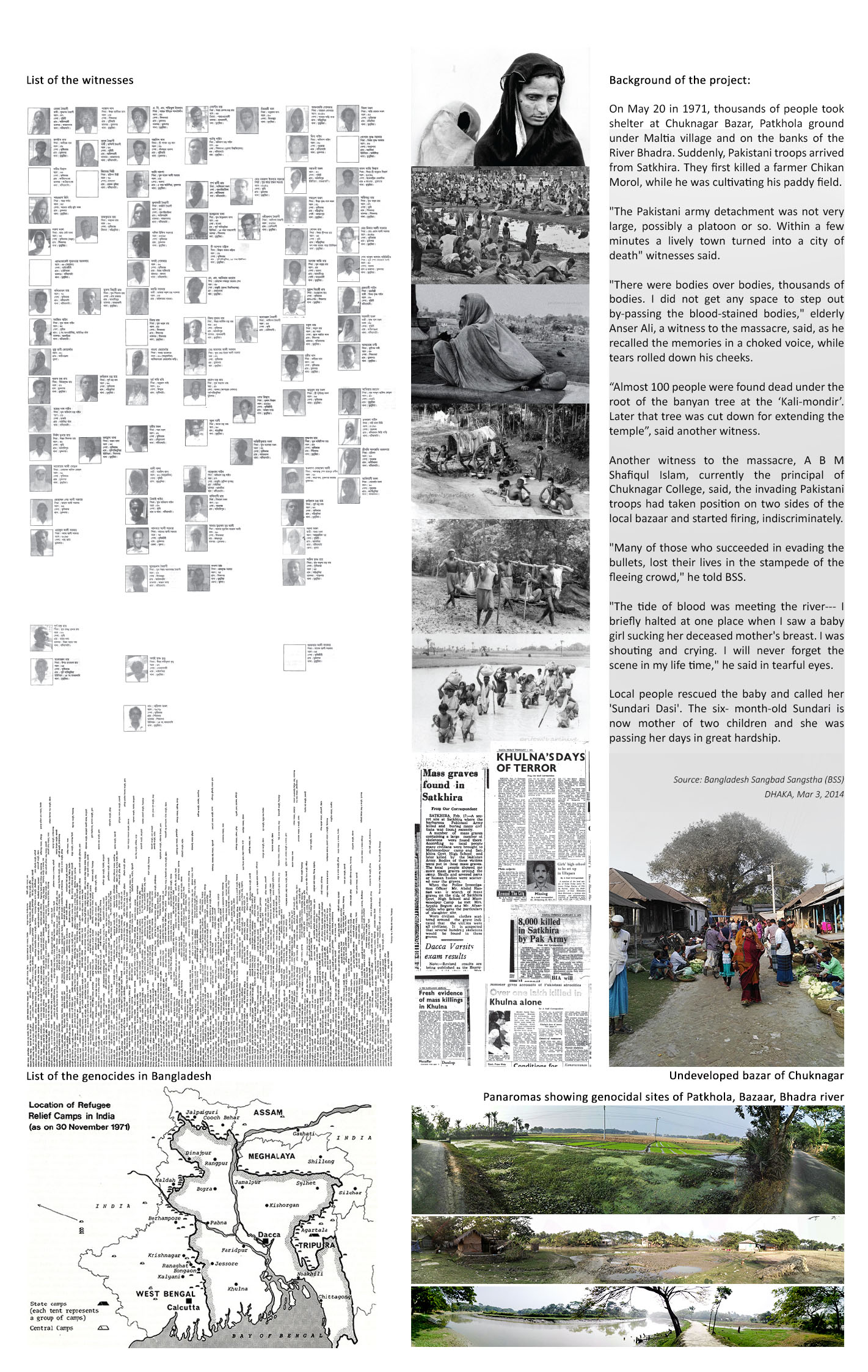
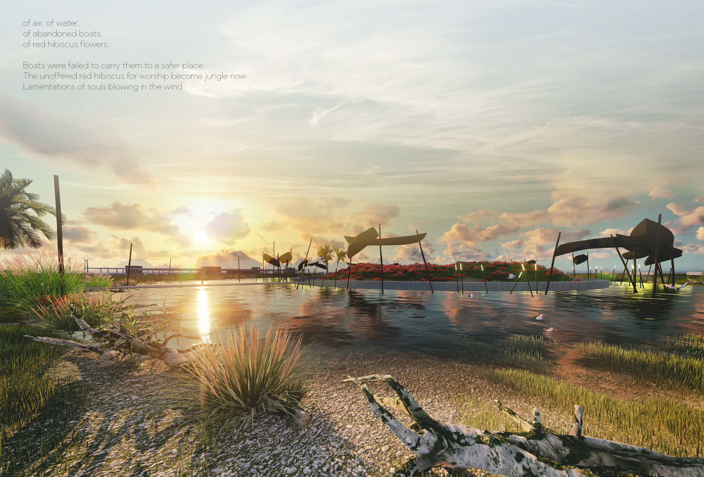
It’s a poem of an old river which used to carry sediment to a fertile land. Once it carried thousands of lives and it was about to transfer them to a safer place and it failed to do so as it had to float their bodies and blood.
It’s a poem of that fertile land which is kept bleak. It could have been the feeding-source of patriotism for the after generation. It’s a poem of that wretched paddy field which still weaves with the wind, whispering a poem, a sad poem, of a mass killing of 8,000-10,000 lives. A poem which is kept myriad to the world for more than 4 decades. This untold tale should be told; it’s screaming should be screamed again; its tear should keep wetting hearts…
Genocide is unsolicited and unscrupulous to the whole world. It’s been happening worldwide due to political, social, economic, religious, cultural and so many ins and outs. In order to prevent genocide, we must realize it’s devastation.
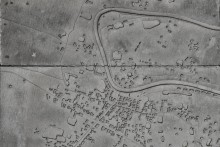
Bangladesh had her own brutal birth in 1971, on a number of immeasurable sacrifices of genocide and torture. Since torture was getting excruciating on the minorities of Khulna region, thousands of these locals collected what belongings they could and went to a village called Chuknagar, from where they were about to go towards the Indian border by boat. Here they lost all of their belongings, cash, and jewelry, their families got tattered and a minimum number of 8000-10000 people were killed from a gathering of about 1 lac eluding people by a small group of Pakistani Army within 3-4 hours. Upon the departure of the unit, the locals disposed of the bodies by throwing them into the river and the nearby ponds. As the death toll raised to 4,200 they just lost count. The bodies kept floating with the silts and people couldn’t use the river water or eat fishes for the next 6 months.
According to numerous eyewitnesses and survivors, it’s the biggest genocide that happens in the liberation war of Bangladesh, 1971. Like many others, it is not even documented or acknowledged. It’s been 46 years since then, and that undeveloped paddy field, Bazar; losing it’s ‘Kheya-Ghat’, is still there with its broken temple. With the death of these witnesses, who can still tell the truth with their tear-stained eyes, the oral history is decaying day by day.
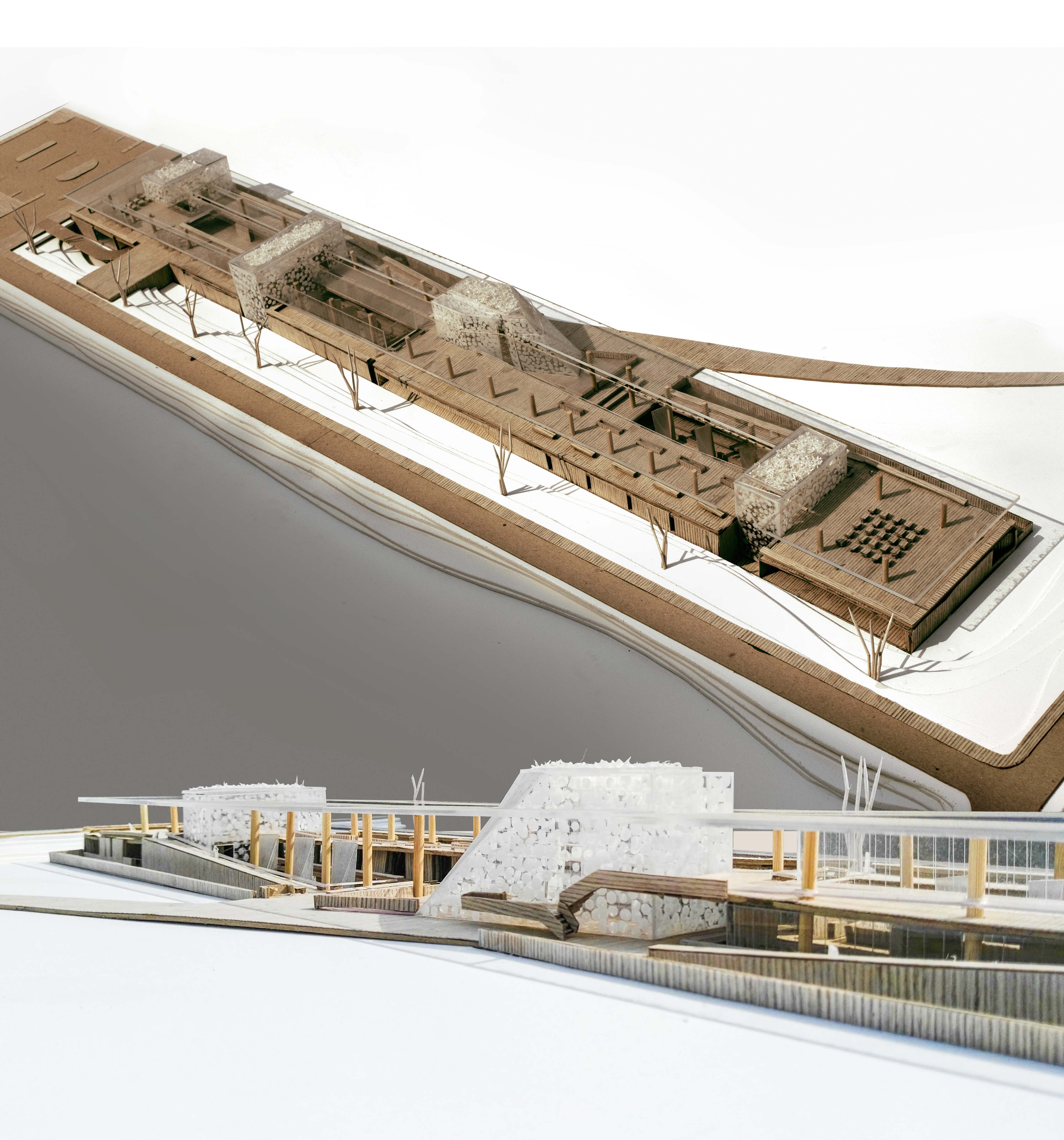
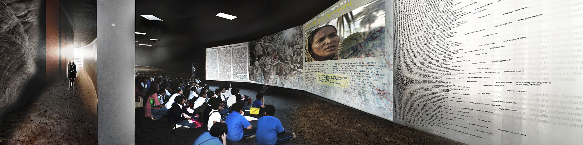
Plotting all these historic footprints on a master plan, three historically intensive zones are proposed with three strategic programs: A Documentation and Research Institute with a memorial on the paddy field, a factual gallery on the bank of that Bazar and a contemplation shelter which is accessed by a boat ride across the river Bhadra. A guided tour, both with signage and narration, is also proposed marking a historical point of reference for the future which will link the past with the present and enable people to realize that hatred is not the solution stopping genocidal acts, they have the individual responsibilities for the peace to humanities.
Description of the journey:
The journey starts from research institute and documentation center where you get a general overview on the genocides of the liberation war of Bangladesh,1971. Here is a research school that will collect, organizes and publish documents on this subject. A central library, movie tower, gallery, the archive may help one to obtain actual orientation about genocide and torture.
From information center, the visitor will get a distant view of Chuknagar memorial. From here the journey passes through the villages where the killing took place. Signage and integrated installation facilitate visitors after 5 to 10 minutes of walk. after reaching the river bank visitors will have some refreshment facilities such as washroom, authentic restaurant and a watch tower.
The bank of the river is reclaimed for a factual gallery which is sited beneath the silts. The Kali temple, a new banyan tree, a ghat and the light shafts give river to back the Bazar. From the factual gallery, it’s possible to see the bazaar along with the exhibits. The journey ends with a boat trip to the contemplation shelter.
For the resiliency of the development, a phenomenological approach of keeping architecture humble and down to the context is taken in terms of materials and construction, which also keeps the senses close to the actual facts.
Bangladesh is a land full of resources yet the economic security of its considerable portion of population is at stake today. Especially the economy of Chittagong Hill Tracts (CHT), the home of several ethnic communities (EC), is weaker than the rest of the country. Statistics shows, the average household income of Chittagong Hill Tracts is 40% less than the national average household income. Approximately 44% people of CHT belong to different ethnic communities and 54% of them live below poverty line.
Historically the issue has a deep and spreading root. When Kaptai dam was built in 1960, approximately 18,000 families lost their land in Kaptai lake. The Kaptai lake keep extending until the rainy season of 1962 and 54,000 acres of cultivable land was submerged in this process. As a result a large number of local residents lost their farming land which was their main source of income. The situation became even worse when the settlers from different part of the country started to come and live in the CHT under a strategic population transfer plan during 1978-1984. Within a decade from 1981, the CHT population increased by 67.95 percent.
In these adverse situations, Monjulika Chakma showed a glimpse of hope towards the betterment of the economic condition of the local inhabitants. She was a young entrepreneur. She started “Bain Textile” a business of indigenous loom. She is now a successful entrepreneur and has three showrooms of “Bain Textile” in Rangamati and one in Cox’s Bazar. She proved that the economic problems of the IPs can be solved by indigenous loom business which is also a huge part of their rich heritage.
Since the indigenous loom can be a realistic solution for the poor economy of CHT, Bangladesh Small and Cottage Industries Corporation (BSCIC) has proposed a workshop and marketing facility for the ethnic population of CHT. However, it is not possible to make workshop for every community since there are many remote places in Rangamati where ethnic communities are residing. So, BSCIC has also proposed storage facilities in the remote areas of Rangamati district.
The site of the loom workshop and market place is located in Manikchori, Rangamati. As Manikchori is situated at the Chittagong-Rangamati Highway and also it is not very far from Rangamati town, this is an ideal place for this project. Moreover, Manikchori is a junction point of Rangamati and Khagrachori district. So, this facility will be able to serve a part of Khagrachori as well as Rangamati.
The main feature of every ethnic community in CHT is that they strictly follow their tradition in every aspect of their lifestyle. For this reason, traditional construction materials of CHT like bamboo, thatch, bamboo fence, wood has been preferred over modern construction materials like concrete or steel in this project. As they are familiar with these materials very well, it will be easier for them to accept this facility as their workplace. Even construction and maintenance of these structures will be pretty easy for them.All the structures are made elevated from the ground to provide proper drainage during heavy rainfall and follow their tradition. Every mass has huge openings since the humidity of Rangamati is very high due to Kaptai Lake. These large openings will keep the inside environment comfortable for the people working in here.
There are basically three types of workshops in the proposed project- (1) Bain workshop (Traditional Indigenous loom), (2) Loom workshop, and (3) Bamboo workshop. Approximately 700 people will be able to work in these workshops. There are total four decks on the lake situated at the west side of the site. Among them one deck is provided for bamboo seasoning, one deck is provided for washing of loom clothes and other two are accessible to people.
At the starting of the site, a large area is kept empty for organizing fair during festivals. It gives a great opportunity for social gathering. At the east side of the fair there is a bazar (market place) and an exhibition facility. The bazar is divided into two parts. One part is dedicated only for BSCIC, where products produced in the workshops of BSCIC will be sold. The other part is for locals, where people from nearby communities will sell their goods. It will work as a platform to sell their home made goods and thus will have an impact on their economic condition. The exhibition will show us the rich tradition of indigenous loom of Rangamati. There will be samples of traditional loom products of the seven ethnic groups which are practicing loom for hundreds of years. Their traditional tools will also be exhibited in the exhibition. I also want to include their rich history of loom practice in this exhibition facility.
There is a multipurpose hall and café behind the fair ground. The café is situated in such a place that it can serve both the people from workshops and the people who have come to visit the fair or multipurpose. Administrative office and a research center is situated next to the multipurpose and café. The center will research on the development of both quality and design of the products. There is also a storage facility behind the research center. Since, this storage facility is situated between the workshops and the research center, it can serve both.
This model can be replicated in other thanas of Rangamati. People will be able to store their home made product in these storage facility. BSCIC can collect these products on weekly or bi-weekly basis and sell it to their customers. Additionally, a medical facility is proposed to minimize the health hazards related to loom production.
Since, a large portion of total population of CHT is the ethnic communities; it is not possible to develop the economic condition of CHT without them. This project aims to create a facility which will alleviate their socio-economic condition while maintaining their tradition. For this reason, this project has space for both social and economic activities.
Reference: Ahmed, K Iftekhar & Kabir, Kh Hasibul ( 2005) A study of traditional housing of “PAHARI” communities in the Chittagong Hill Tracts (CHT), AHDPH, Bangladesh.