Echoes of the Estuary: A Tourism Center at Hatiya Dwip

World Environment Day 2026

Urban [Re]Stitch

Syed Nazrul Islam Convention Center | Metropolitan Architects

| From the Architect |

The project is a mixed-use public building that offers a good number of public facilities with a welcoming entry to an urban scale plaza to show respect to the people, the main driving force of the democracy as well as the project. It is a large scale project for the people and designed to meet the need of the locals.

The site area of this project is a high-density under developed area that has evident lack in providing community facilities as needed to meet the demand of the area. This project offers a number of community facilities namely; Multipurpose Hall, Library, Community Health Facility, Office area and etc. for the local community in a reasonable and affordable price under one roof and as an addition it also gives the possibility to introduce a public space for the locals in an urban scale that faces the river. Therefore the project has significance in different levels such as in its background, in its design philosophy and execution and also in its scale and openness towards the people.

© Metropolitan Architects

Architectural concept:

The basic notion was to design a monumental public building with an urban scale plaza that offers a variety of spaces and functions. The space is actually a differentiated transformation where both the inner and the outer space are enticed by transition. The aim was to guide people to an inseparable state of spaces, which is revealed in light. To depict the phenomena, the spaces here raise questions among the visitors mind silently in search for a truth pushing them to a realization of history.

© Metropolitan Architects

Programs are arranged on a raised plaza, which represents a platform of history with hierarchy so that in any interval people can avail themselves in to the openness. The Plaza is a breath in openness and also a place for people to gather and enjoy the riverfront, which has a potential to be developed in future.

© Metropolitan Architects

The space of this convention center is holding the implication of the tragic incident of Jail Killing Day after the liberation war through the dramatic shift of hierarchy. The outer skin of the building in a sense preserving the inner, whereas outside skin standing against the deflection of time. Perforation on the outer surface to penetrate light at an uneven nature illustrates the vantage point of that dark night.

© Metropolitan Architects

Constraints and solution:

The River being at the back of the site was a major drawback at the beginning but was treated in such a manner that the plaza gives visible access to the river and inspires the riverbank to be more visible which initiates future development.

© Metropolitan Architects

At times it had been a bit challenging to work with the client and budget considering the details proposed initially but was improvised and revised later to fit the client’s requirements.

  • 02
  • feature
  • 08
  • 07
  • 06
  • cam 05
  • cam 02
  • 03
  • 05
  • 01
  • 04

ARCASIA Student Competition 2016

© arcasia
© arcasia


THEME

Green Lifestyle

THE ORGANIZING COMMITTEE

The Committee of this competition is composed of members of the Students’ Jamboree Committee, the 17th Asian Congress of Architects.

BRIEF

This is a design ideas competition that invites students in the field of Architecture to contribute ideas and concepts that respond to the theme “Green Lifestyle”. Each country is facing their own sustainability concerns and students are encouraged to identify, at the same time resolve, these issues by using architectural designs.

OBJECTIVES OF THE COMPETITION

Students are free to select a site to come up with design ideas, built or portable or a prototype, which would encourage users to participate in a green and sustainable lifestyle. Students are encouraged to think along lines of cost effectiveness, energy efficiency, low carbon footprint, zero carbon emission and implementable means that may work with one need found in your particular region of Asia, or one which might even be effective when adapted in many different situations.


SCHEDULE

21st March 2016 – 20th May 2016

Submission of design to the respective National Architectural Institutions (NIA)

20th May 2016

Deadline for Submission to the respective National Architectural Institutions (NIA)

17th June 2016

Selection and announcement by the respective National Architectural Institutions (NIA)

End of July 2016

Announcement of final 5 best designs

29th September 2016

Announcement of Competition Result

The Jury Panel

  • Chairman ACAE (Head Juror)
  • ARCASIA, Zone A-Member (Vice Chairman),
  • ARCASIA, Zone B-Member (Vice Chairman)
  • ARCASIA, Zone C-Member (Vice Chairman)
  • Convener ARCASIA Students Design Competition

ELIGIBILITY

Any current full-time student studying Architecture or related courses accredited/ recognized by the respective National Architectural Institutions (NIA) of ARCASIA member countries.

INDIVIDUAL / TEAM SUBMISSION

Individual or team submissions accepted (No limitation on number of team members. Students are only allowed for one submission either on an individual or team basis.)

DELIVERABLES

  1. One file containing one A1-sized layout (594mm x 841mm) in landscape format, including (but not limited to) the following:
  1. Location Plan/ Site Plan/ Block Plan/ Building Plans at appropriate scale;
  2. Minimum one cross-section and or elevations at appropriate scale;
  3. Diagram/ Sketches highlighting the design ideas and features;
  4. Photomontages, Perspectives, and or other illustrations that can illustrate the ideas and design concepts;
  5. Animation is not accepted.
  1. Design Statement of 500 words maximum (font size: 12) in .doc format to explain the overall proposal, with proposal title.
  2. Duly completed and signed Entry Form in .pdf format

ASSESSMENT GUIDELINES

The selected entries will be judged in accordance with the broad assessment guidelines (see below) by the Jurors. The decision of the Jury Panel shall be final and binding on all parties concerned and decisions cannot be appealed against. Participants do not have the right to request for access to the Jurors’ comments or records on the adjudication.

  1. How the identification of sites or green issues can reflect the special context of their country;
  2. How the proposed design can enlighten the understanding of green or sustainable lifestyles.

PRIZES AND RESULTS

  • One Gold Award: HKD5,000 and Trophy
  • One Silver Award : HKD2,000 and Trophy
  • Three Bronze Awards : Each with HKD1,000 and Trophy
  • All shortlisted entries will be showcased at The 17th Asian Congress of Architects (ACA17) in Hong Kong in 2016.

EXHIBITION AND PUBLICATION OF ENTRIES

The organizer is entitled to display or exhibit on any date and in any venue the entries or any part thereof, and publish including the report of the category events together with any selected entries.

LANGUAGE

All entries shall be in English.

ENQUIRIES

For enquiries, please contact Ms Carman WONG and Ms Jocelyn KWOK of Event Secretariat by email at aca17hk@creativegp.com (enquiry only).

MATERIALity | BUET

| Write up from the project submission |

In architecture, the study and application of various materials are very important not only for functional requirements but also for visual ambience. The use of materials in architecture is many times predefined.

Different materials are unique in terms of their properties and therefore, they differ with one another.  So their uses in architecture should also be different in terms of their own properties. But the question is, do we ever think “What the material wants to be”?

This was the concept of the project. The students were to choose a certain material on their own will and design something in the premises of the department that would flourish the characteristics of the material. The key aspect was the designed structure should express the materialistic qualities of the material.

It was a group project, each consisting 4 members. The volume of the designed structure was fixed within 2m x 2m x 2m.

All the students enjoyed designing and mostly constructing their individual projects by themselves and the overall learning was a very joyful experience.

.

Material | BRICK

Availability of ingredients, cost, durability and weather acceptability make brick the ideal and most common building material in Bangladesh. Most of the time, we use brick as a partition material and rarely as a structural part. And as long as the brick is concerned, we like to think it as a material of linear building element. Our goal was to check the accuracy of this tendency we developed over the years and justify whether it is right or wrong.

© Batch 12 _ BUET
Brick © Batch 12 _ BUET


While working with brick we realized it was possible to work with a curve and also ensure maximum structural stability while working with only bricks. Due to the modular character and being available in various sizes, it can also work as a screen as well while combined. Finally, there are many types of bonding possibility. We decided to work with the basic character of dome, arch, screen and bonding. The final outcome was a sitting arrangement that complements the curved eastern wall of Department of architecture building in BUET.

Type of used brick-
a. 5 hole export quality brick (10% porosity) – 9.25”x4”x3.25”
b. Solid thin bricks- 8”x4”x2”

Special Thanks to- Mirpur ceramics and Khadim ceramics.


Material  |  CANE

© Batch 12 _ BUET
Cane © Batch 12 _ BUET


Cane is generally used for an interior purpose such as furniture, screening etc. After exploring various aspects of cane, a shading by using cane was designed. Structural matter of cane, joining and weaving patterns were focused here.

Cane has the capacity of supporting objects as well as bearing compression and tension. On the other hand, it is a very handy material due to its light weight.

The shading was given a curved fluid shape using the flexibility of cane so that its capacity of bearing compressive and tensile strength can be expressed more vibrantly in an aesthetic manner.

© Batch 09 _ BUET

© Batch 09 _ BUET

© Batch 12 _ BUET
Cane © Batch 12 _ BUET


Material  |  JUTE

© Batch 12 _ BUET
Jute © Batch 12 _ BUET


The project is entitled Materiality. As Kahn has said that even a brick wants to be something, we were required to find out what our given material wanted to be, and make it so.

Our material was jute. The basic idea was to express the capacity of jute to bear a tensile load in terms of human ergonomics. It is an interactive wall offering gatherings and rendezvous for people of any age. We defined some spaces for sitting or leaning, and some were left free to be defined by the users themselves. The project very certainly proved that jute is a very strong material in terms of load bearing capacity, as well as unbeatable in ornamental beauty.

2.cdr

Sheet2
Jute © Batch 12 _ BUET


Material  |  PAPER TUBE

Tube © Batch 12 _ BUET


The idea behind this project was to explore a material that is less costly, recyclable, and environment friendly. So paper tube was chosen for the installation.

Some characteristics of paper tube as a building material are following:
1. Finishes include ground, polished, painted or lacquered.
2. Have excellent sound & electrical insulating properties.
3. Easy to saw, drill, tap, thread and punch with ordinary tools.
4. No need of skilled labor
5. Provide excellent resistance to compression, impact, vibration, corrosion and moisture.

But paper tube catches moisture very quickly. To prevent this, the tubes were laminated with plastic. However, laminated paper tube is easily available abroad.
A multi-functional space frame was designed and was easily made by paper tube by following Fuller Dome principle. To join the paper tube with each other, bolts and nuts were used.

Tube © Batch 09 _ BUET

Tube © Batch 09 _ BUET

Tube © Batch 09 _ BUET

Tube © Batch 12 _ BUET


Material  |  STEEL

Steel © Batch 12 _ BUET


The design of the installation is based on the bending and tensile load bearing properties of steel.

Tensile cable will bear the load of steel pipes structure which follows the bending property. Steel cable bearing the load follows the tensile property.

Joints:
Ms welding rod used by an electric welding process.

Pipe bending process:
Pipe bending machines are typically human-powered, pneumatic powered, hydraulic assisted, hydraulic driven or electric servomotor.

Used process:
Rotray draw bending: Rotray draw benders are the most popular machines for use in bending tubes, pipes and solids for applications like handrails, frames, motor vehicle roll cages, handles etc.

Other properties:
Malleability- Rolled into sheets, bars and rods.
Load bearing- Heavy load bearing capacity.
Lustre- Shiny metal with an attractive finish.
Strength- Very strong and resistive to fracture.
Bending- Can be bent into desired shapes.
Durability- Long lasting and durable.

Steel © Batch 12 _ BUET


Material  | TENSILE FABRIC

Tensile Fabric © Batch 12 _ BUET


Properties:
1. Light weight (0.7-1.3 kg/sqm)
2. Negligible bending and compression
3. Covers maximum span with minimum support
4. Has only tensile strength on the material
5. Strength 60-80 psi (conventional architectural fabric), higher strength can be achieved now
6. Aesthetically pleasing

Why tensile fabric?
1. A modern approach towards experimenting materials in architecture
2. Eco-friendly, less carbon footprint
3. More durable materials using compressing force like brick in earthquake prone areas
4. Low maintenance cost
5. Less hazardous

Design approach:
Tensile fabric works as an excellent roofing that can easily hold a space between. We tried to use that quality and took a more functional approach. We designed an information booth which was temporary and portable.

Tensile Fabric © Batch 09 _ BUET

Tensile Fabric © Batch 12 _ BUET


Material  |  WOOD

Wood © Batch 12 _ BUET


The basic concept was to design something that can signify the characteristics of the “material” wood and cannot be expressed by other materials that way. This led us to the decision on how we will express wood as a material- exploring wood joints.

The basic idea was to design a wooden space frame in which all the connections would be made by different types of wood joints. In the frame, 2”X2” wooden planks were used. The planks were tilted at different angles to show that wood joineries work in abrupt directions also.

Wood © Batch 09 _ BUET

Wood © Batch 09 _ BUET

Wood © Batch 12 _ BUET


The entire frame was made joining the wooden planks by classical wood joints without using any adhesive, nail or screw. Six different types of joints are used- tenon and mortise joint, right angled tenon and mortise joint, scarf joint, dovetail joint, double dovetail joint and butterfly joint.

.

Project Gallery >>

  • Brick
  • Cane 03
  • Cane 04
  • Cane 01
  • Cane 02
  • 07
  • 2.cdr
  • Sheet2
  • Tube 05
  • Tube 03
  • Tube 04
  • Tensile Fabric 01
  • Tensile Fabric 02
  • Tensile Fabric 03
  • Steel 01
  • Steel 02
  • Tube 02
  • Tube 01
  • Wood 08
  • Wood
  • Wood 04
  • Wood 05

Accessibility of Children Play Spaces in Dhanmondi | A Syntactic Study

In this article, the author shares a part of his research aimed at interpreting the urban physical context by referring to three elements: place, path, and people. While this tripartite framework serves as the conceptual foundation, the research narrows its focus to play spaces, pedestrian paths, and children between the ages of 4 and 7, respectively. Accessibility—defined as the “intensity of possibility of interaction” among people in space and time—serves as the core spatial quality that integrates these multidisciplinary themes. The empirical setting is Dhanmondi Residential Area (DRA), a planned residential neighbourhood in Dhaka, together with its periphery.


Fig01. Architecture and its context

The following analytical study evaluated accessibility with reference to the notion of topological space in space syntax. In such notion, urban space is represented as a single system of interconnected lines. Different urban spatial qualities (in this case accessibility) then are evaluated with reference to the syntactic values of those lines.

Fig 02. Street network in DRA was represented as two types of line segment: pedestrian lines or sidewalk lines and all movement lines or centre lines by using DepthmapX software (Turner, 2004) on Mapinfo platform.


Results from the syntactic study across 400 meter, 800 meter, 1200 meter and 2000 meter radius are presented in Figure 3. Pattern of integration of sidewalk segments shows that the streets near Rabindra Sorobor, Mirpur Road near Science Laboratory and Shat Mashjid near Road 9a, forms the most integrated places in the system (colored red and yellow in 2ia, 2ib, 2ic). That means, possibility of pedestrians using the paths and places near these paths will be higher in intensity than other areas in the system. Pattern of integration for centre-line segments shows that long stretches of Mirpur Road, Shat Mashjid Road and Green Road are the most integrated segments. That means possibility that all people (including vehicles) using these paths is higher than other segments in the system (colored red and yellow in 2iib, 2iic, 2iid). Overall, pattern of integration of sidewalk segments also shows that the most integrated line segments are located within DRA as compared to the surrounding areas such as Jigatola and Kalabagan.

Figure 3
Figure 3

Pattern of choice of sidewalk segments shows a mosaic pattern of higher and lower values throughout the system. That means, possibility of pedestrians passing through the streets are quite evenly distributed. Within DRA, the bridge linking two sides of the Dhanmondi Lake (Road 10 and 8a) and the front street of Sultana Kamal Women’s Complex show high choice value (colored red and yellow in 2iiia, 2iiib, 2iic,). Pattern of choice of centerline segments shows that adjacent areas surrounding DRA, such as Kalabagan, Jhigatola, show greater potential for all types of movement (including cars) as compared to the internal streets of DRA. This is possibly due to the longer segments in DRA (which is a planned development) compared to the shorter segments in the surrounding areas (which are non-planned developments).

Accessibility of play spaces in DRA was measured by extending line segments from the entry gates into the playgrounds and parks. Figure 4 shows the relative accessibility of the public play spaces for both sidewalk- and centre-line segments. Considering sidewalk-line segments, the Rabindra Sorobor Park Area along Dhanmondi Lake shows highest accessibility followed by the Kalabagan Playground, Abahani Playground and the Road-8-Playground (marked from darker to lighter dots in Figure 4a). When the centre-line segments are considered the playgrounds along the Mirpur Road shows higher accessibility (Marked darker in Figure 4b). It is interesting to note that pattern of pedestrian and all-movement accessibility of the play spaces varies within the system. For example: The Rabindra Sorobor Area along Dhanmondi Lake shows relatively higher accessibility only with reference to the pedestrian segments whereas the Road 8 Playground and the Kalabagan playground show higher accessibility in centre-line analysis. This implies that while designing or redesigning play spaces it is necessary to study pedestrian and vehicular movements separately in the urban context of Dhaka.

Figure 4
Figure 4

However, while measuring accessibility of play spaces for particular group of people (such as for children), some limitations arise. For example, in this study the syntactic measures ignored the attractiveness of play spaces (such as size, surface quality, provisions of facilities, naturalness etc.). Nevertheless, possibility of interactions in play spaces will be expectedly affected by the attractive attractiveness of play spaces. However, few methods attempt to measure attractiveness of urban spatial opportunities quantitatively. Gravity model developed by geographer Walter Hansen (1959) is one among those few methods.

According to gravity model, while measuring accessibility of play spaces, relative sizes of the spaces and other ‘distance-decay’ factors (Hansen, 1959) need to be considered. For example, in Dhanmondi Residential Area, the Abahani Playground is 12 times bigger in size than the Road 4 Playground. This might significantly affect accessibility pattern of the play spaces beyond the configuration of the paths. This assumption seems valid. During our field study, some of the users (children aged 10 to 14) at Abahani Playground mentioned that their house is located more than one kilometer from the playground, whereas, children in the Road 4 Playground reported that they live within few hundred meters from that playground (Figure 5). Thus, in the context of Dhaka, it is important to consider the effect of decaying distance (i.e. opportunities near one’s house has higher attractiveness than opportunities located far from one’s house) while designing catchment radius.

Figure 5
Figure 5

Another aspect related to measuring accessibility of play spaces for children is that Children’s preferences for urban play opportunities might be influenced by social factors such as their age, gender and family background (Aarts et al. 2012; Islam, 2008). These are mostly people based factors that changes over time (i.e. different in different times of day, week, month, year etc.). Figure 6 graphically shows that possible pattern of three children using different formal and informal play spaces will vary across times of day. This space syntax based study however did not distinguish the people factors in its analysis.

Figure 6
Figure 6

Thus, from the above discussion it can be summarized that accessibility measured across path network (i.e. by using space syntax measures), would provide a useful, but generic, representation of children’s accessibility to play space. Explaining accessibility for specific group of people in urban space can be well improved through a combination of other accessibility methods, (such as gravity method which is place based) and behavioral models (such as agent based model which are individual based). From such understanding, Figure 7 shows an outline for measuring accessibility of play spaces for children in three dimensions, namely place, path, and people. Being flexible in its measure, a combined model might have better implication during policy, planning and design in Dhaka.

Figure 7
Figure 7


READ [PART 1] Architecture and its Urban Context: Place, Path and People

Works cited:

AARTS, M., Vries, S. I. D., Oers, H. A. V., Schuit, A. J. (2012) Outdoor play among children in relation to neighborhood characteristics: a cross-sectional neighborhood observation study, International Journal of Behavioral Nutrition and Physical Activity, 9(98).

HANSEN W. G. (1959) How accessibility shapes land use, Journal of the American Institute of Planners, 25:2, 73-76.

HILLIER, B. (2012) The genetic code for cities: Is it simpler than we think?, in J. Portugali et al. (eds.), Complexity Theories of Cities Have Come of Age, 129. DOI 10.1007/978-3-642-24544-2_8, Springer-Verlag Berlin Heidelberg.

HILLIER, B. AND HANSON, J. (1984) The social Logic of Space, Cambridge University Press.

HILLIER, B AND PENN, A (2004) Rejoinder to Carlo Ratti, Environment and Planning B: Planning and Design, 31: 501-511.

ISLAM, M. Z. (2008) Children and urban neighborhoods: Relationships between outdoor activities of children and neighborhood physical characteristics in Dhaka, Bangladesh, Unpublished PhD thesis, North Carolina State University.

MILLER, H. J. (1999) Measuring space-time accessibility benefits within transportation networks: Basic theory and computational procedure, Geographical Analysis, 31(1).

TURNER, A. (2007) New Developments in Space Syntax Software, Proceedings of the 6th International Space Syntax Symposium, Istanbul Technical University, June 2007.


George’s La Dolce Vita | Interior by Ar. Rubayet Tanveer

|From the architect|

We wanted to build something crafty. Pursuing visions creates distinctive things and each step in the pursuit becomes exciting and in turn opens new possibilities. In approaching to create we believe in listening to our surroundings and materials and then applying our craft to what we hear.

©Rubayet Tanveer Chowdhury

©Rubayet Tanveer Chowdhury

©Rubayet Tanveer Chowdhury

©Rubayet Tanveer Chowdhury


Italian is a nicely flexible cuisine and we walked an interesting tightrope. We looked for a balance as we’re pulled to one side by Dhaka’s expectations of Italian cuisine and to the other by the thought, “What would an Italian chef do with these ingredients?” For example, an eboir isn’t part of Italian cuisine because it’s not grown in Italy, but does that mean it shouldn’t be part of an Italian restaurant in a place where it does grow? So we’re inspired both by asking how ingredients might fit into Italian cuisine, and by pursuing the answers; because we’re continually brought back to, why are we here doing this restaurant, and, have we made choices that please our senses and our aesthetics?

©Rubayet Tanveer Chowdhury

©Rubayet Tanveer Chowdhury

©Rubayet Tanveer Chowdhury

©Rubayet Tanveer Chowdhury

©Rubayet Tanveer Chowdhury


Like with trying to listen to ingredients, we attended to what the space told us when we designed it. The view was the original attraction. The next step was to create seating which gave guests the best access to that view. As we built from there, we wanted to find elegance in simple materials that would quietly add up to a feeling of being somewhere special.

©Rubayet Tanveer Chowdhury

©Rubayet Tanveer Chowdhury


Gallery View:

  • 19nef
  • 18nef
  • 15nef
  • 17nef
  • 16nef
  • 9nef
  • 10nef
  • 12nef
  • 11nef
  • 13nef
  • 14nef
  • 8nef
  • 7nef
  • 6nef
  • 5nef
  • 4nef
  • 3nef
  • 2nef
  • 1nef

Workshop and Book Launch by Dr. Mahbubur Rahman

| Shajjad Hossain |

Society of the twenty first century, with more complex social, economic and political systems, requires graduates with transferrable attributes that make them employable. Universities all over the world are continuously updating their course curricula based on learning outcomes that produce job-ready graduates who can make more effective contribution to the profession, the society and national development. These universities are aiming to provide a total educational experience leading to degrees with the specialist knowledge graduates will need for specific careers. The aim is to also develop key skills like communication, teamwork, problem-solving, initiative and enterprise, planning and organization, self-management, learning, and tech-savvy—the eight most highly employer-valued skills at present time.

Realizing the need and scope of shifting away from conventional teaching oriented content to student oriented learning in the curricula of public and private universities of Bangladesh, Institute of Architects Bangladesh (IAB) organized a well-timed day-long workshop on “Graduate Attributes and Developing Learning Outcomes”. The workshop, held at North South University (NSU) in Dhaka on 28 January 2016, was conducted by Dr. Mahbubur Rahman, currently the Dean of Engineering & Design at the Kingdom University of Bahrain. Dr. Rahman is a former Professor of NSU when he also served as the General Secretary of IAB. .

The interactive workshop introduced the ideas of Graduate Attributes, Missions, Goals and Objectives. It also forwarded the idea and way of setting curricula through the formulation of Learning Outcomes and integrating them into a comprehensive education through mapping. In connection to his experience of establishing and reviewing several Architecture Programs, and preparing others for accreditation, both at home and abroad, Dr. Rahman suggested re-orienting the approach to education to what students actually learn, rather than what topics are to be covered in a course and by extension in a program. This will lead to curricula design or revision based on learning components, demonstration of measurable outcome, and use of appropriate assessment tools to determine the achievements and capabilities of a graduate. He also emphasized on setting up mission, goal and objectives, and aligning all the courses, down even up to the level of a lecture or a particular topic, with those for comprehensive learning.

Photo Courtesy |  Tawfique Rahman
Photo Courtesy | Tawfique Rahman

Dr. Rahman presented different topics (program pillars), along with guidelines and tips on how to prepare them, while the participants in groups got involved in mock exercises on preparations of “Program Mission Statement” and “Program Learning Outcomes” by asking themselves—“what we want our graduates to be able to do with the knowledge, understanding, skills and values they acquire through an educational program that are demonstrable and measurable”. The highly successful event was attended by thirty three academics from sixteen different universities of Bangladesh offering B.Arch. programs, in addition to program managers, employers and representative of IAB. The participants, some of whom came from Khulna, Chittagong, Sylhet, Pabna and Gazipur, expressed their satisfaction in this timely workshop under IAB’s CPD program, and wished that more such workshops be organized in future.

The IAB education workshop was followed in the evening by a  launching and discussion program on the book Dhaka Urban Reader edited by Dr. Rahman and published by the University Press Ltd. (UPL) in the same venue. The Mayor of Dhaka North Annisul Haque graced the occasion as the chief guest while a panel of distinguished speakers deliberated on the book in particular and the problems of Dhaka city in general. We will soon publish another report on the well-attended program.

Dr. Rahman, a Commonwealth Scholar and McNamara Fellow who has taught architecture at various universities in 6 different countries since 1985, runs an educational consultancy in Canada. He is the author of more than 100 international publications and four other books in addition to the current one, including Society, Architects & Emerging Issues (Commonwealth, 2006), Old but New :: New but Old (UNESCO, 2009) and City of an Architect (DelVista, 2011). He was also involved with the preparations of National Building Code, Dhaka Structure Plan, National Housing Policy, Imarat Nirman Bidhimala, Urban Poverty Reduction Program, etc.

Sculpture for Nagasaki Peace Park at Japan | (winning entry) by Anindya Pandit

মূলভাবনা

মানুষের দুঃখের কাল উপস্থিত হলে সে অভিভুত হয় এর তাৎক্ষণিকটায় । সে ভাবে – এই বুঝি তার সব শেষ হয়ে গেল- হতাশা তাকে গ্রাস করে, সে শোকবিহ্বল হয়। জীবনের দীর্ঘ পথের গল্পটা সে তখন গিয়ে যে রাস্তায় দুঃখ-দুর্ঘটনাটি ঘটে সেই বিন্দুতেই দৃষ্টি নিবদ্ধ করে এবং দুঃখাভিভুত হয়। সেই মুহূর্তে অন্যদের কাজ দুঃখভারাক্রান্তকে জীবনের দীর্ঘ পথের সেই গল্পের কথা মনে করিয়ে দেয়া এবং তারাও এমন অবস্থায় নিপাতিত হয়ে একইভাবে অভিভূত হয়েছিল- এইকথাটুকুর মাধ্যমে সহমর্মিতা প্রকাশ করা। জীবনের দীর্ঘ পথের গল্পটা আমার প্রকৃতির কাছ থেকে শিখেছি বটে, কিন্তু সহমর্মিতা ও সহানুভূতি প্রকাশ একান্তই মানুষের অন্তরের শিক্ষা । সাহায্য ব্যাপারটা বাহিরের বস্তু আর ‘সহানুভূতির’ ভেতরের।

জাতি হিসাবে অন্য জাতির দুঃখের দিনে তাই সাহায্য ব্যাতিরেকে সহানুভূতি জ্ঞাপন একাধারে মিথ ও লোকাচারের অংশ আজও পর্যন্ত।

১৯৪৫ এর ৯ অগাস্ট এর মনুষ্যসৃষ্ট নৃশংসতম ঘটনায় তাই শোকপ্রকাশ বা সহানুভূতি প্রকাশকেই আমি আমার নৃশংসতম ঘটনায় তাই শোকপ্রকাশ বা সহানুভূতি প্রকাশকেই আমি আমার স্থাপত্য ভাবনায় প্রাধান্য দিয়েছি এবং একইসাথে বিশ্বশান্তির আশা ব্যক্ত করতে চেয়েছি। বিশ্বশান্তির আশা ব্যক্ত করতে চেয়েছি।বিশ্বব্যাপি সর্বজনগ্রাহ্য condolence সহানুভূতি বা শোকপ্রকাশক প্রতীককে ত্রিমাত্রিক দৃষ্টিতে ধরার চেষ্টা আমার নকশায় রয়েছে।

আয়াতাকৃতি কালো কাপড়ের টুকরোকে তলার দিকে ত্রিভুজাকারে কেটে বুকের বাঁপাশে ধারণ করে আমার যে দুঃখ প্রকাশ করি- এর পেছনে যে দার্শনিক গল্পটি আছে তা হলো-

‘তোমার দুঃখ শুধু তোমার একার নয়। আমাদের সবার। তোমার বুকের ভার আজ আমার সবাই ভাগ করে নিয়েছি, তুমি দুঃখ করো না। দুঃখ সর্বজনীন। তোমার বুকে শান্তি আসুক।‘

কংক্রিটে তৈরী সাড়ে চৌদ্দ ফুট উচ্চতা নিয়ে যখন এই প্রতীক উঁচু হয়ে দাঁড়াবে

তখন তার শীতল কালো বুক থেকে ডানা মেলবে শ্বেত কপোত।

“আছে শুধু পাখা, আছে মহানভ-অঙ্গন

ঊষা-দিশা-হারা নিবিড়-তিমির আকা

ওরে বিহঙ্গ, ওরে বিহঙ্গ মোর,

এখনি, অন্ধ, বন্ধ করোনা পাখা।”

।। দুঃসময় ।।

রবীন্দ্রনাথ ঠাকুর

Theme:

Lesson from life depends on our experience of existence in nature but condolence or empathy is the true expression of our inner feelings that can be foreseen beyond help. Soul mate beyond partners still remains as a quest in our culture and myth.

The idea was to reflect condolence for the victims in 9 August,1945 and envisage peace at global context. The three dimensional form is the symbolic expression of concern and condolence.

The form of the sculpture was articulated  to contemplate the feelings through rectangular black paper with triangular subtraction at the bottom with an intention to express- ‘ It’s not only yours, we all mourn with you.’

White wings of peace will definitely be on air from the blank black- concrete wall.

© Anindya Pandit
© Anindya Pandit
© Anindya Pandit
© Anindya Pandit
© Anindya Pandit
© Anindya Pandit
© Anindya Pandit
© Anindya Pandit
© Anindya Pandit
© Anindya Pandit
© Anindya Pandit
© Anindya Pandit
© Anindya Pandit
© Anindya Pandit

Architecture and its Urban Context: Place, Path and People

The article presents the 3P (Place, Path, and People) framework—for analyzing urban contexts. The initial part of the article conceptually elaborates the place-path-people framework with reference to urban spatial quality such as scale, diversity and accessibility. The discussion emphasizes the interconnected and open nature of urban spaces and architectural sites more broadly. Furthermore, the article identifies and examines potential challenges that may arise when applying the framework in practice.


PART 01

By definition context refers to the setting of an idea, text, statement or form, in terms of which it can be understood clearly. For an urban architecture, the context is the surrounding environment and its various constructions – physical, social, economic, ecological, cultural and so on. Within the context the (re-) new work of architecture is supposed to be weaved in an integrated way. The complexity that arises while discussing urban context of architecture is that architecture creates and recreates context through both its ‘closeness’ (architecture as bounded object) and ‘openness’ (architecture as ‘space’ — related to all other spaces). This article, however, will focus mostly on the analysis of open characteristics of architectural spaces, while recognizing its ‘relative closeness’.

It is of no doubt that rigorous analysis of surrounding physical environment is important for better understanding, or rethinking of, any context. In this article I argue that, in an abstract sense,urban physical context can be analyzed across three key matrixes among others—place, path and people. Place refers to any space that people identify as a unit. Paths are connecting spaces among and between places. People form a particular kind of space that has direction in space-time.

Place, path and people can be measured objectively while these are open to subjective interpretations. For example, while places can be identified as dots in space, sense of place differs from building to building. Paths as ‘geometric lines’ between or among two or more locations are quantitatively analyzable; however different paths might symbolize different meaning in particular context. Similarly, people’s movement can be studied as space-time vectors while their preferences are difficult to understand without cultural studies. In cities,place, path and people form interconnected systems; not discreet ones. It is to be noted that historically interrelations between place, path and people have been an ignored topic in architecture, transportation planning and social sciences. These disciplines show profound mastery in studying the elements of place, path and people separately. In case of architecture, the focus has been on place-making, where paths and people are taken for granted. Transportation planning identifies roads and streets as autonomous entities, which is not true.  Social sciences focus on people, where place and path are assumed to be the innert background, which obviously is not the case in cities.

Given such background discussion, this article will argue that lack of understanding about the interactions between people, path and place is one of the major gaps in understanding context and architecture.

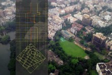
From urban design perspective, let’s understand place, path and people in terms of scale, diversity and accessibility. In terms of scale, spatial design problems vary in different urban scales due to the degree of interacting forces among place, path and people.In that sense, a‘city’ is nevera ‘big building’. For example, analyzing spatial configuration of a staircase is relatively simple within a private residence where as spatial analysis of a foot-over-bridge can be extremely complex in dense urban areas. Although small in scale, a successful foot-over-bridge must fit properly within the transportation network and public movement pattern. This demands enormous analytical study at a greater scale than the scale of the to-be-designed form.

As about diversity, urban spaces and buildings are hardly of homogeneous use. Different types of activities of different people group intermingle in the same space (mixed-use spaces, plazas, streets, parks, play spaces etc.). While a mono-functional space can be designed with traditional wisdom or standardized codes, forms of contested and multi-use spaces demand continuous reevaluation of the interactions of place, path and people.Many of such interactions are emergent, rather than stagnant. Interactive outcomes of place, path and people can be considered more like the embryo of an egg; not only the shell. The shell, although very important, is a temporary state in the process of life. But see, the ‘embryo’ reminds us of potentials of life.

Broadly, accessibility means people’s freedom to move from one place to another through paths within space-time constraints. In cities, people hardly remain confined within their neighborhood. And people mobility behavior varies across age, gender, income group and so on. Thus, accessibility of an urban space depends on its connection to all other spaces. Even, if the connections are right, it also depends on people’s preferences as well (i.e. whether people like to have access to that space or not).

The above understanding of urban space involving place, path and people negates ‘closed-site’ as core-ground for making architecture.A site is both closed and open. Such statement however introduces some practical complexities in architecture. For example: in terms of scale, decisions on the surrounding urban environments are often beyond the domain of architects and urban designers working in a particular project. About diversity, it is challenging to include heterogeneity of activities during spatial design. Question might arise: How to find sizes and shapes for an urban plaza in a participatory way, if people drastically differ in their opinions and if their opinions change over time?Regarding accessibility, complex problems might arise in understanding street hierarchy. For example, vehicular streets,although they enhance accessibility for the car owners,reduces accessibility to nearby opportunities for pedestrians, children and elderly.

Given the practical complexities are addressed in different degrees in practice with due insight, the place-path-people approach for understanding architecture and context together demands attention. However, it should be noted that call for studying socio-spatial context in finding form for architecture is not new (See, Venturi, 1966; Schumacher, 1971; Jacobs, 1961; Broadbent, 1973 for example). Also, abstracting the urban built environment with few key elements for analytical and theoretical purposes is not new (See, Lynch, 1960, Hillier and Hanson, 1984 etc.). This article adds that while analyzing socio-spatial context place-path-people can be three important dimensions for analysis specifically to address spatial qualities, such as accessibility and diversity, at different urban scales and for different group of people. Place-path-people view also creates possibility for utilizing state-of-the-art computation technologies – gifts of the 21st century.

Also place-path-people approach can help understanding physical urban context in rapidly urbanizing cities. In this regard, I will briefly share some of my personal observations in the urban context of Dhaka while highlighting the relevance of place-path-people approach.

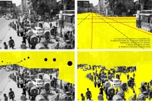
In my view, present architectural and planning practices in Dhaka inspire the idea of an ‘island-context’. Plot-based, guarded, gated and multi-storied apartments in Dhaka are some easily recognizable elements of the islands. The ‘islands’ seem to be ‘blind’ to the surrounding places, paths, and most importantly, to people’s lively interactions in space.It can be argued that an island-context is a product of miss-matched interactions between places, paths, and people. Presumably, while designing buildings within island-context, the designer assumes a closed-site. The point of departure here is to ask whether place, path, people is worth giving an attention in architectural and urban design studies and how their relations can be well studied during design process to address the adversaries related to the built environment.

Pragmatically, do the place-,path- and people-based understanding suggests any direction? The first direction is an emphasis on socio-spatial research in architecture, urban design and planning. Such research should be multi-disciplinary; and should encompass both quantitative and qualitative perspective. Second,recent developments in computational modeling (such as GIS and CAD systems) can be explored extensively to simulate complex relations between place, path and people.

READ [PART 02] Accessibility of Children Play Spaces in Dhanmondi : A Syntactic Study

Works cited:

Venturi, R. (1977) Complexity and Contradiction in Architecture, New York: Museum of Modern Art.

Schumacher, T. (1971) Contextualism: Urban Ideals+Deformations, Casabella, 359-360, p. 79.

Jacobs, J. (1961). The Death and Life of Great American Cities. New York: Random House.

Broadbent, G. (1973)Design in Architecture: Architecture and the Human Sciences, Surrey, UK. (PP. 73-86)

Lynch, K. (1960) The Image of the City, The M.I.T. Press, UK

Hillier, B and Hanson, J (1984). The social Logic of Space, Cambridge University Press.

Rethinking the Cityscape, Mohakhali | AIUB

| Write up from the project submission |

Mohakhali, being located at the heart of North Dhaka,  plays a vital role to the city dwellers by occupying the lands as commercial facilities. Every day people are using  it to avail various services including retails, office, restaurant, business, hotels etc.

As it is situated at strategic location of the city, it is accessible to the users by different modes of transports. Infact the linear  site positioned itself as an in-between layer of two transport systems like railway and heavy vehicles. It is also surrounded by several residential zones like Banani, Mohakhali, DOHS etc. It has airport terminal towards its northern direction and an inter-bus terminal at its southern side. So the site creates a gross potential as a central business point for others. But due to ignorance and  uncontrolled development, the linear site gradually emerges as an urban barrier. Meanwhile, it does not provide a proper working environment for its users. As a result, the structure becomes only a mere shelter not space for its users. So the user concern about their usable space along with their other recreational facilities and the issue ‘‘RETHINKING’’arises. The existing cityscape of Mohakhali must be rethink for its betterment. Here the users find a lack of recreational space, buffer space, opacity, noise, glare, pollution, impurity etc in their day to day life. They could not able to feel that space and do their work only for their economic urgency.  So with the help of architecture people initiate its possible solution for the users as well.

Rethinking the Cityscape © Trina,Tania Azad | AIUB

Rethinking the Cityscape © Trina,Tania Azad | AIUB

Again we cannot propose the same solution that we have done for our previous problems. We do not want to patron the premature urban infusion. No more glittery high-rise egotistical urban nothingness. The proposal is based on regional type logical precedents that created unique points of an urban civic node within the traditional Dhaka city context.

Rethinking the Cityscape © Trina,Tania Azad | AIUB

Here the proposal initiates a truthful, authentic and unique experience. An identity constructed by a substance through its functional meaning, the high quality working environment, the community potential and its strong connection to the surrounding urban fabric. So the Mohakhali area can become a true urban habitat through its structural rethinking. The projects need to be understood as a process, not as an end result. It concentrates on the principle of structure, community and infrastructural development through the active connectivity of users. So the in-between layer must be created as a perforated translucent layer where users can enjoy their valuable time.

concept_form derivation
Rethinking the Cityscape © Trina,Tania Azad | AIUB

So after the completion of a survey, human connectivity, transport system and all those relevant facts of existing site, the search of philosophical theory started along with its conceptual derivation. Now it becomes compulsory to do a combination of human, motion and structure. The structure should pose perforation within it. As such people would able to enjoy their break time from work in those perforations and again can join their work which would apart from noise and pollution.

Rethinking the Cityscape © Trina,Tania Azad | AIUB

05 sections copy

Rethinking the Cityscape © Trina,Tania Azad | AIUB

Mohakhali ELEVATION
Rethinking the Cityscape © Trina,Tania Azad | AIUB

The entire collective combination of concept and studied data would come together as a reflection of form derivation. At the first phase, the elongated site is segmented according to thumb rule of building code. Then it rearranges their position from traditionally isolated blocks and angled according to north-south direction. So the angled cutting edge of blocks ensures wide vision from the structure. Now the solid form extrudes vertically and gets clearance for public access. Again above the podium portion, the creations of green and open space invite people to gather there. As every day, a number of people come there to perform their duty, so it would be compulsory to provide open space vertically as well. Then the core extension added to the podium and to the rest of the part. According to the functional requirement, it requires four cores after every two hundred feet gap. After that modular extension needed for its further development. For further extension, a single module creation would be preferable for avoiding its massing contamination.  So the usable space becomes angled due to the environmental fact and the core portion become straight for its structural and functional aspects. Here the progression of module continues according to the need and also maintaining the terrace for users. Again the module has the possibility to multiply for space requirement.

Rethinking the Cityscape © Trina,Tania Azad | AIUB

Rethinking the Cityscape © Trina,Tania Azad | AIUB

Therefore, the structural aspects become other challenges for its sustainability. As such it requires a composite structural solution which combines internal frame column, core and truss tube.This variation of the framed tube consists of an outer frame tube, the “Hull,” together with an internal elevator and service core.The Hull and core act jointly in resisting both gravity and lateral loading.The outer framed tube and the inner core interact horizontally as the shear and flexural components of a wall-frame structure, with the benefit of increased lateral stiffness.The structural truss tube usually adopts a highly dominant role because of its much greater structural depth.As such the form opens a journey of experience for its users instead of using their existing opaque layer as a barrier. So likewise, the entire layer ensures future extension and also fulfills the urgency of the present.

Rethinking the Cityscape © Trina,Tania Azad | AIUB


  • 00 CONCEPT SHEET
  • 00 CONCEPT SHEET
  • EXISTING SCENARIO-10
  • SCHEMATIC DRAWINGS-4
  • concept_form derivation
  • MODULE DETAIL-8
  • PODIUM PLAN-6
  • 05 sections copy
  • Mohakhali ELEVATION
  • SKIN ANALYSIS-9
  • Model Image-02
  • Model Image-01