Re-envisioning Tejgaon Industrial Area: A Public Realm for the Future| NSU
The Tejgaon Industrial Area was first established as an ‘industrial District’ in the Masterplan for Dacca drawn up in 1959 by the Dhaka Improvement Trust. In 1968 DIT planned the district as a Light Industrial Area and divided it into large plots appropriate for industrial development. Of course, over time land division and acquisition have resulted in much smaller and larger plots as well. The development of Tejgaon as an industrial zone went on unabated post-independence with an increase in residential and commercial activities during the 90’s. With the development of the Economic Zones in peripheral areas of Dhaka many Industries started shifting to the new areas during this time. Though this period shows a significant shift in land use patterns, to date the majority of land use is still allocated for Industrial use with Commercial, Residential and Institutional uses also mediating in between. The nature of change is consistent with the rapid financial growth during the start of the new millennium that spurred the random development of a commercial belt along Gulshan Avenue. That coupled with the development of the Gulshan-Tejgaon link road has brought a new boost in commercial growth especially in the north fringe of the area. The steady loss of importance as an Industrial zone has thus been compensated for by a new emerging need for a mixed use zone to support the concentration of commercial activities that spill over from Gulshan Avenue up to Gulshan-Tajgaon Link road.
The Detailed Area Plan for Dhaka recognizes the ensuing change in the character of the Tejgaon Industrial Area. According to DAP the TIA is to develop as a mixed-use zone. However, there is no clear indication of the nature of this development. Recent trends in creating high rise buildings along the northern fringe are indicative of high-density commercial developments. If this trend continues the area will not only become subject to over-densification but also create severe pressure on the environment and ecology of the area. The objective of this studio is to develop create a vision for the future of TIA that permits high density mixed-use while maintaining sustainable, people-oriented and environment-friendly principles for urban design. The students are encouraged to develop independent ideas that are coherent with future changes and formulate strategic guidelines for the development of the area as such.
OBJECTIVES:
To develop guidelines & regulations for overall planning- building heights, road widths, circulation system, drainage, blue-green system and land use.
To determine edge conditions.
To visualize an active public ground for the area that serves both the locality and the city
We have presented three different approaches to re-envisioning the area from three different student groups for the audience to have a comparative opinion.
PROJECT _1: Sajid Mahmood Khan |Rehnuma Tabassum |Nowshin Nawal |Lifath Jahan
PROJECT _2: S.M. Mahmudul Haque | Suhrath Tasnim Rahman| Rahat Hasan| Farhana Abdur Rashid| Abu Rayhan
PROJECT _3: Farhan Hasnine | Safuil Basher | Maliha Akter Aaysha | Roshni Islam
[Text and image- from students]
PROJECT _1: THE HAPPY NEIGHBOURHOOD
Student Name: Sajid Mahmood Khan |Rehnuma Tabassum |Nowshin Nawal |Lifath Jahan
Zone Detailing by:
Sajid Mahmood Khan | Rehnuma Tabassum
Tejgaon Industrial Area Thana (Dhaka Metropolitan) is bounded by Gulshan Thana on the north, Ramna Thana on the south, Gulshan, Rampura and Ramna Thana’s on the east, Tejgaon and Cantonment on the west.
Historically, the area has been a center of industrial activity in the city. Numerous plants and factories are in Tejgaon, in such diverse industries as garments, food processing, metal works, pharmaceuticals, etc. Tejgaon became the major attraction for the immense industrial activity to meet the ever increasing demand of growing population and found its location in the core of the city from the peripheral location.
According to the Detailed Area Plan (DAP), journalized in 2010, one of the major hindrances behind the improvements or expansion of Tejgaon Industrial Area is constantly changing land use of this city core. The DAP suggests that this industrial area should be relocated outside the boundary of Group-C area of the Detailed Area Plan (DAP). The government of People’s Republic of Bangladesh has recently decided to turn the entire Tejgaon Industrial Area along with its major roads into a commercial as well as residential district through a comprehensive master plan. Upon analysis of the whole Tejgaon Industrial Area, we were able to identify a number of problems in the selected area.


The Concept and Design Strategies
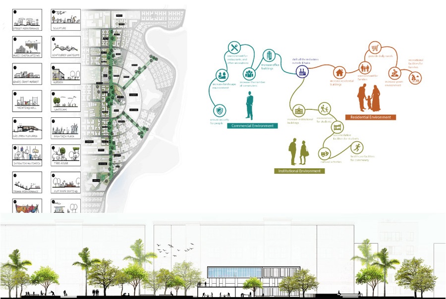
To revive the lack of urban activity, it was thought of converting the industrial zone into a mixed-use zone. So the idea of introducing independent neighbourhoods was strategized to keep the area active 24/7. However, if the whole area is converted into one single neighbourhood, a number of areas would still remain dead after specific hours. To eliminate this completely, it was thought to split the area into several segments, each segment becoming a separate independent neighbourhood that merges with the other through a common public facility. The neighbourhoods are divided according to the walking radius so that every facility is available within a walking distance. A person can walk a distance of 500m in 5 minutes so the neighbourhoods are divided according to the radius.
Each neighborhood has a mix of all the functions, like, commercial, residential, mixed-use, institutional, mosque, health, and open space, service according to different percentages so that each zone has a priority of a single function. Although each neighborhood has a separate focus, the goal is to create a balance of all the facilities in each neighborhood, and that every neighborhood becomes independent. However, although independent, each neighborhood depends on or connects to another for specific public functions. For instance, people from other neighborhoods come to Neighborhood 02 for the giant shopping mall, and to Neighborhood 04 for universities. So that public interaction between the neighborhoods is active.

With the elimination of the industries, the proposed land use tries to balance the functions among the seven neighbourhoods. Along with the functions, a more defined plot system and road network have also been proposed. The proposed land use also adds public green spaces in the neighbourhoods.


The Master plan
The new master plan proposal tries to conserve most of the existing infrastructure of the area. Since the industries are to be moved out, there are scopes for new functions to be introduced in the spaces that are holding industries at the moment. This favors the balancing of functions in the neighbourhoods the area is to be divided into. Rather than completely demolishing and reconstructing, the proposed master plan attempts to create a public realm for the future by renovation and enhancement of the existing urban fabric.
The master plan proposes an enhancement of road network throughout the site with minimum alteration of the existing urban fabric, improving the road connectivity with the surroundings, however, restricting through roads in the neighbourhoods, promoting walkability; also converting a number of vehicle-free roads within the neighborhoods. However, this has been done ensuring efficient vehicular accessibility to all the plots from the other sides. Moreover, as the required facilities are placed in a walking distance, the need for taking a vehicle is brought down. Public recreational spaces, educational institutes, super shops are made available to every neighbourhood and also ensuring safer roads with proper crossing, bicycle lanes, wide footpaths and buffer spaces.
Police station and fire service at the central block ensure proper connectivity with all the neighbourhoods. Putting lumps of green wherever possible, a network of green is established following the road network, which connects the larger green areas, like parks or public squares.

Neighbourhoods
The seven separate neighborhoods have their own distinct characteristics, however, all of them are independent, having a mix of activities that keep them active throughout the day and night. As per the design concept, the strategies have been applied to create self-sufficient neighborhoods, improving public accessibility while also ensuring the safety and necessities of the residents.
Taking the “Neighborhood 02” into account, we can take an in-depth look at how the strategies have been applied.

The existing land use of this area expresses the dominance of commercial activities, however, with the elimination of the industries, there grows scope for introducing new facilities primarily to satisfy the needs of the concept, creating an independent neighborhood.
A number of tertiary roads have been turned into complete pedestrian roads, so that they can host various public activities and moreover, people can walk throughout without vehicular disturbance. This does not, however, completely omit the access of vehicles inside. A few one-way vehicular roads have been introduced, ensuring vehicular access to every plot.
Being a commercial based area, and along with residences and educational institutes, the neighborhood demanded public spaces. With various people coming in throughout the day, public spaces, a park, market place and outdoor sitting areas have been introduced.
A community park at the heart of the neighborhood that links access from all the connected roads and allows people from all sides. The park, itself, contains a number of programs for the visitors: a playground, indoor games facilities, gymnasium, tea/coffee stall, shop, and an amphitheater. The park is designed to host both the residents and other people coming here for school, college, commercial purposes or for the shopping mall. The park can also host cultural festivals throughout the year.

PROJECT _2
Student Name: S.M. Mahmudul Haque | Suhrath Tasnim Rahman| Rahat Hasan| Farhana Abdur Rashid| Abu Rayhan
Zone Detailing by:
Suhrath Tasnim Rahman| S.M. Mahmudul Haque | Rahat Hasan
The inventory of land use within the study area contains details on the land parcel that characteristics as plot size, plot ownership and market value. Detailed information on existing structures including type of structure, ground coverage, number of stories, use of buildings, density of plots was also included through physical survey.
The analysis shows that a substantial proportion of existing land use has an increased plot density consisting mainly of industrial land use. Further depth categorization of land usage within each of the area’s main land uses as commercial, industrial, residential, institutional shows three main uses of Industrial land that dominates the total industrial establishment within the study area, namely chemical, within the study area, pharmaceutical industry, clothing industry. While the residential land uses inside the region is found nearby the Hatirjheel lake along Hatirjheel-Gulshan interface road with a wall built. These residential uses grew critically as unplanned settlements pushed the very lack of quality of life. Not just this, but the plots allocated with settlements are crowded in by a barrier along the interface road blocking the visual connection of the lakeside. Furthermore, the existing pattern of the landuse consisting of commercial and residential lifestyle has no connection and is completely detached. According to Bangladesh Planning Research Conference (BPRC), a study approves that the absence of proposer land use control, the growing trend in commercial development may result in such a development that may deteriorate and is more unlikely to collapse the entire cityscape. In addition, the study also mentions of Detailed Area Plan (DAP) who suggests “an additional proposition that if possible then this industrial area should be relocated outside the boundary of Group-C area of the Detailed Area Plan (DAP) and the area should be kept as an extension of Kawran Bazar for future commercial cum office zone or a large scale open space cum recreation zone”.
However, while surveying the area, it occurred that despite industrial zones located, the roads are much wider than necessary meaning less traffic now and later which is a positive remark as we introduce the commercial development that will play as a significant part in defining the economic growth trend of the region with no road distress. When working on the establishments of the area, our goal was to turn the place into an iconic zone that is larger and doesn’t lack people as it does now. Removing the wall blocking the lakeside view will not just increase its visibility but also the market price of land in Tejgaon industrial area tentatively.
Tejgaon will meet the growing commercial space demand in the capital as the transformation of Tejgaon Industrial Area is necessary. The master plan will contain, integrate public spaces and other human necessities, so that people can profit socially as well as economically. Strategic planning was crucial as the existing and proposed trends were to be merged to maintain the region’s timeless essence.
Firstly, after a thorough study, the analysis reveals different categories associated with land use. Further detail categorization of land use within each of the area ‘s major land uses as Commercial, Residential, and Government/Institutional Organization. Secondly, the existing land characteristics and structure within the study area indicates some of the known nodes and its connectivity that is in a haphazard manner. By shedding light on one formal category of image elements to which we can split the region conveniently, more spaces were identified alongside and proposed an efficient connectivity that doesn’t disrupt the current flow. A legible spine is produced by introducing three major focal points that articulate the flow and connect the major land uses that were located. Finally with the spine as the center of attention in urban planning, our priority was set focused to bring the lively into the area through the recollected nodes by the optimum use of public spaces. These were further divided into classifications of its value to the surrounding such as, Type A (Environmental Value), Type B (Social Value) & Type C (Economical Value).
Type A class serves nature in a couple of ways by reducing pollution (air, noise, water), Increasing ecological diversity, and reducing energy consumption i.e. parks, community gardens and cemeteries. While Type B class treats the social users, improved quality of life, increased mental and physical vitality i.e. walking, sports club and cultural amenities. Last is Type C class where parks, squares, gardens and other public spaces are becoming an essential business and marketing tool, higher property prices i.e. bazaar and retail markets.

Initially when the Public Works Department (PWD) prepared a master plan during the year of 1950, the structure supported the emerging of Industrial use and was voted in the year 1959. Soon after ten years, the Department for International Trade (DIT) planned the are as a light industrial zone but couple of years later the area went through a massive unplanned development, According to the Dhaka Metropolitan Development Plan (DMDP), the non industrial land uses (commercial, office, etc) have increased taking a great toll on the industrial uses gradually. In the year of 2014, the government has decided to turn the area into a commercial cum residential district and hence provides the basis for evaluating the transition in land use in this area between 2005 and 2015.

As stated in DMDP, being close to Dhaka city’s core Tejgaon attracts numerous business activities in this area. Meanwhile during the study of this area, the critical analysis shows that most commercial land use buildings within the district are high-rise building categories and so we encouraged the expansion of commercial along with mixed-uses thus growing trend in commercial activity. However for a pedestrian activity with no modes of transportation, there was no flexibility in the region as the only footpaths denoted were simply near the major road adjacent to the highway, and mostly left deconstructed. The disconnection of the internal road linking the district was particularly poor whilst the lack of parking places didn’t go unnoticed.
A hierarchically interlocked transport system and pedestrian routes of varying degrees and continuity is maintained in the proposed plan. The roads are further divided into three categories, the primary drives functions as the major road (i.e. car, cus, trucks, auto rickshaw), secondary drives will mainly transport vehicles of a average scale (i.e. cars, auto cngs, cycle and rickshaws) while the tertiary drives will have auto rickshaw. and rickshaw movements. Serving drives in a given policy will increase its efficiency and connection as well as remove any road encroachments that have been identified during the study in the area. Along the focus points of the spine, three bridges are proposed for a smoother fluidity in movement causing no distress to the vehicular routes.

Correspondingly in the earlier statements of growth trend, each of the 430 plots exists a large range in plot size in the study area, ranging from 0.5 katha to 200 katha. Keeping the suggestion of DAP in mind, both building and land use map was carefully adjusted through the division of plots in major sectors. While commercial is proposed with 20-40 katha, residentials is confined within 0.5-15 katha. PWD recommended shifting the CSD, the BFDC and the truck from the food department to a convenient location and using a portion of the liberated field for multi-use purposes and selling the remaining plots so that the funds could be used to rehabilitate government institutions.
The plan was carefully drafted and then continued with the assessment of project feasibility, the creation of a database of public and private establishments in the region and so on. After a strong green spine that connects most of the site, includes an open public space in the heart that has a variety of public functions all supported by pedestrians continuing a strong vertical flow. The spine classified into different public spaces has activities that are safe i.e. Library, Foodcourt, bazaar, sports club etc. People of all age and different users are welcome to come and influence a vibrant public hub. In the near future, recreation and leisure activities in urban parks such as walking , running, cycling and picnicking will increase due to higher living standards and people looking for a healthier lifestyle.
The proposed master plan will not just increase nodes of the district but also encourage the public hubs as landmarks of the area, fulfilling the goal of bringing the city to life and fabricating a better lifestyle.

As an important part of the cultural regeneration, as factors such as mixed-use buildings, environmental conservation projects and, in particular, public art contribute to the creation and growth of the area ‘s culture. Being at almost the core of the district, our proposed plan placed a cultural hub for both commercial and residential zones to serve people of various purposes.

The cultural hub consists of classrooms, events, and etc. It serves as an extracurricular activity for the youth through the interactive learning center by supporting arts and preserving heritage. Surrounded by an performance stage and various seating spaces, the public movements are well encouraged.


The circulation is very fluid through the plaza, allowing other interactive activities to take place, such as small retail shops, outdoor cafe’s, event plaza and etc ensuring a safe activeness at any time of the day. The connections established in the design continues through defined pedestrians. It creates a well inviting environment for the family-friendly neighbourhood and a communal gathering connecting from the public realm.

PROJECT _3: TEJGAON FOR GENERATION Z
Zone Detailing by:
Safiul Basher

In the late ’50s, Tejgaon was announced to be an industrial area but since then it did not develop as expected. Rather it was always an industry dominated mixed-use area in the heart of the capital. So recently the government announced to move the industries for the sake of the environment of the city.


Based on the concept, we have proposed to create a common platform for GenZ, and other people who are part of the area. To ensure that, we have proposed to increase institutes, offices, residences. Our area is divided into three zones based on that proposal. We have also proposed to connect them using various mixed-use functions, public spaces to establish the public realm which is lacking here.


We have proposed a commercial belt, institutional belt, and residential belt for distinguishing. As our main focus is to bring in more youngsters here so we have proposed an institutional belt where students from different interests will be able to build a knowledge-sharing community. We have proposed a residential zone which is divided into 3 parts, the first one is alongside to Hatirjheel, the second one is a residence-based mixed area with a line of shops and facilities which will support both study and live. Finally the third is dormitory to accommodate the students. As the government has announced to move the industries from Tejgaon, new windows open here for business. We designated a zone for our work part where the land use is mixed with Industrial and commercial. By placing a business district here, an inter-exchanging community will grow between the corporates and students. We, at the same time, have proposed to connect the functions by adding green spaces, market places, public places. We ensure the proper distribution of building use to develop the public realm here.


One of the goals of our design is to introduce the public realm around the area. We have proposed to create interactive layers of public activity that connects the ground floors of different buildings. We have also proposed to increase night-life activities, to attract people into public spaces so that the area is no longer dead. The plots we have chosen to achieve that goal are commercial and institutional. For commercial plots, we have proposed to create public spaces linearly in the middle of each plot. Those spaces will transform into a public gathering environment. Office workers will find the place as a refreshing environment during their breaks from work and after offices break. The residents and students will be drawn to this place because of its green and versatile nature.

For the institute, we have proposed to merged two plots and created a mass that connects the two plots via bridges. The open gallery in front of the institute connects all groups of people. Keeping in mind the privacy of the university, we have proposed to define the gallery in such that everyone uses it without disrupting the security of the institute. Thus we connect the three major users [commercial user, residential user, institutional user] using the spaces.
PEOPLE ALSO VIEW
Printed Publications

NEXT 50: Collective Futures

ASPIRATIONS AND IDEAS: Designing with Context