The goal is to outline a planning and design guideline for the periodic cattle market, where both the customer and the seller would feel safe during this pandemic. Due to the financial instability of the people, the number of cattle for Qurbani may be less this time than other times. Again, due to the gathering of many people at the Qurbani cattle market, the Corona situation may deteriorate. However, according to some, if the number of Qurbani Haats is reduced, the virus is less likely to spread. But is that really so? Reducing the number of Haats will increase the pressure of people in one place and it may be difficult to control. If the number of Haats increases and proper management is ensured in all cases, then the gathering of people in one place may be lessened and at the same time, it will be easier to supervise.
In that case, we will try to discuss how the risk can be reduced. We will also discuss how cows and goats can be displayed considering the overall situation, how there can be circulation of human and animal movements, how to dispose of waste and how to reduce the spread of the virus.
Animals for sacrifice will come from different parts of the country to different markets. On the way to the market, there is a possibility of the animal being infected with corona. And it is also likely that the virus will transmit to humans from the breath of an infected animal.
Considering from different angles, it is clear that in each case, we are at risk. Again, it is also evident that social distancing measures are difficult to implement in a crowded place like Haat. Moreover, rain and mud will add complexity to the problem as the Eid-ul-Adha coincides with the rainy season this year.
The plight of cattle sellers in the market can be noticed every time. There is a lack of food as well as an unhealthy environment along with high health risks due to Aedes mosquitoes. There is no alternative than to follow the basic hygiene rules and social distancing measures. Of course, everyone must wear a mask and at the same time maintain a minimum distance of 2 meters or 6 feet from each other.
In addition to that, a preparedness plan is required to control the transmission as much as possible.
First of all, it is important to ensure maximum safety when both people and animals enter the Haat. In that case disinfection chamber or tunnel can be arranged at the entrance. Since many people will gather, there may be a large disinfection tunnel instead of separate disinfection chambers. It will take a minimum of 20 seconds to walk through. Both humans and animals can go through such tunnels.
If space is adequate, then a certain distance should be maintained between each cattle. And if that is not possible then cattle belonging to the same owner or from one place should be kept together while maintaining a distance of 10 feet from the nearest cattle belonging to another owner.
Arrangements can be made for the buyer to stand at a certain distance from the animal. In that case, there may be a bargain or conversation with the seller who is with the cow while keeping a distance.
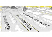
Every time in a Qurbani Haat, it is seen that there is a lot of chaos due to the movement of people and cattle using the same lane. Sometimes accidents happen. If there is a way to differentiate between animal lanes and buyers’ walkways, it may be possible to solve this problem. If a drain can be placed next to the cattle path for waste disposal and the lanes for humans and cattle are separated, then the percentage of road dirt with dung can be reduced. Again, the buyer will be able to move and see the cows in a risk-free manner.
If there is a dedicated path for moving the cattle, some of the people appointed by the Haat committee may take the cattle out of the Hat and deliver it to the owner following all safety precautions. This would also play an important role in new employment in this difficult time. However, there should be a fixed rate for delivery per cattle set by the municipality.
In every 250 meters, there should be an intersection of human and animal roads, so this place has to be crossed carefully. Nodal points will also be provided for collecting ‘Hasil’, money transaction points like bKash, snack shop, hand wash will be provided at a certain distance.
For every ten cattle, there may be a space where the customer can be shown the cattle around if needed and the seller can sit and relax there if he wants.
The asking price can be tagged with each cow so that different buyers do not crowd in one place to ask the price again and again.
Each cow may have a barrier around the cow’s neck with a code number zip lock. The information of the cow can be presented by scanning the barcode or QR code. However, it might not sound realistic considering the limited time available, but it can make the management much easier. After the sale, the price of duty cost of the Haat can be paid only by looking at the code number without crowding with cattle in front of the Hasil center.
On the occasion of Eid-ul-Adha, animal sellers come to the market from far away with a hope to get the best price of their year-round efforts. During this annual event of Eid-ul-Adha, the price can be fixed separately by the government according to the weight, age and other criteria of the cow so that the sellers are not deprived in any way and at the same time the unscrupulous sellers cannot destabilize the market unnecessarily. At the same time, bargain over price can be avoided which eventually would facilitate quicker trade. Moreover, the risk of corona can be largely reduced.
In addition, there should be temporary arrangements for vendors to stay and have their meals separately without crowding in the food kiosks or street sides during this pandemic situation.
Temporary sheds can be arranged for sudden rains and importance should be given to rainwater drainage systems.
And finally, after the event, the waste of the market should be cleaned properly.
About the Authors:
Md.Iftekhar Rashid Rafat, Student of Architecture, Ahsanullah University of Science and Technology.
Sakib Abdullah Khan, Student of Architecture, Ahsanullah University of Science and Technology.
Context contributor: Sheikh Rishad Ahmmad Aurnob, faculty member, Ahsanullah University of Science and Technology.
Two of the new ideas that have come into being are quarantine and isolation. If someone is infected or suspected to be, he/she should be isolated. This isolation can be institutional or non-institutional. World Health Organisation (WHO) has provided a guideline for home quarantine or quarantine in the non-institutional setting.WHO suggests various guidelines or rules for home quarantine like, allocating a separate room with adequate ventilation, maintaining at least one meter distance from family members, using separate bathrooms, frequent hand washing and so on [1]. Cases show that general family members are unable to maintain all the steps properly and get infected. Can we have more effective tools to fight this pandemic? Is there any precedent ideas from our traditional architecture? Will that traditional approach can cope with our urban life?
Tradition as a solution
The folk tradition of Bengal Architecture has a large collection of supportive house types for special activities. One of the most popular practices is Atur-Ghar (আঁতুড় ঘর), also known as Ram-Kure(রামকুঁড়ে). We can learn some details about this type of house from the Charyapada, the most ancient literature (written) of our region. The Charyapada is a collection of mystical poems, songs of realization in the Vajrayana tradition of Buddhism from the tantric tradition in Assam, Bengal, Bihar, and Odisha [2]. Generally, Atur-Ghar (আঁতুড় ঘর) or Ram-Kure(রামকুঁড়ে) is a type of temporary small house that was built to provide medicare to pregnant women. The word Atur-Ghar (আতুর ঘর) came from the Sanskrit word Antokuti (অন্তকুটি). The word evolves from Sanskrit to Bengali অন্তকুটি (সংস্কৃত)>অন্তউড়ি> অন্তড়ি (ওড়িয়া)>আঁতুড়ি>আঁতুড়. The word “Antouri” (অন্তউড়ি) is found in The Charyapada in one of the poems of the great poet Kukkuri for example:
“ফেটলিউ গো মাত্র অন্তউড়ি চাহী।
জা এথু বাহাম সো এথু নাহি।”
এখানে ফেটলিউ মানে গর্ভমোচন করা।অন্তউড়ি মানে আঁতুড়ঘর।
Ram-Kure (রামকুঁড়ে) is a temporary small house but in some areas, it was constructed permanently. Permanently built Ram-Kure(রামকুঁড়ে) was used as storage of firewood after the medical care purpose was fulfilled. The North-west side or also known as Esankon (ঈশান কোনে) is the best position for the house according to Vastu. The house is generally built next to the kitchen or Dheki-Ghar (ঢেঁকিশালের). Available materials like bamboo, mud, golpata, hogla, or buchuli are used to build Ram-Kure. The basic shape of the house was Quadrangle or circular. The conic shaped roof structure was made out of bamboo and then covered by straw (খড়). One of the most identical parts is the high window that remains open at day time and closes at night. High windows are covered by a curtain made of bamboo strips and rope [3].
Although the situation of infectious disease is not similar to the treatment of childbirth, the principle can be used for non-institutional isolation facility design. After analyzing the traditional Ram-Kure, we can point out five principals as follows; orientation, material, ventilation, separation, and multipurpose use. The question remains about its adaptability in the urban area. For the urban area, we have to solve issues for example; land scarcity, material for a temporary structure, technical requirement and easy maintenance.
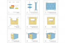
DIY Isolation Module construction
To adopt the traditional solution for home quarantine in an urban area, we can install the temporary structure on our rooftop or negative spaces. We propose to design a 100 sq. ft. room as an isolation module. The principle of this construction is cost-effective and DIY (Do It Yourself) so that people can practically relate to this. Rooftop is a better solution because the circulation of the resident will not cross over with an infected patient. A single module will accommodate a person with a bed, a desk & a gardening window. For a healthy environment, natural light and proper wind flow are the main priorities.
To make the isolation module cost-effective, reusable material is the best solution for example, “Egg Crates”. Construction materials needed for isolation module are plastic egg crates, GI wire and PVC sheet. Plastic egg crates are modular and porous which is helpful for DIY construction. The 100 sq ft isolation unit is a module for one person, which can be increased as the need arises. A portable toilet pod can be installed if needed.
As our healthcare facilities are reaching their capacities and hospitals around the country are becoming overwhelmed with patients, we should look for new alternative possibilities. Designing a rooftop quarantine facility for every home could be an effective solution to reduce community transmission, thus releasing pressure on the healthcare system. This traditional approach is a fast and efficient design solution that is flexible, fast assembled, mobile and simple structures that can be implemented anywhere.
About the Authors:
1. Ar. Sumon Paul (Session: 13-14, Graduation 2019, Dept. of ARC, SUST)
2. Md. Abdus Satter (Session: 13-14, Dept. of ARC, SUST)
The article is an abridged version of the discussion where architect Renzo Piano, often referred to as the world’s most prolific museum designer, talks about his philosophy of designing buildings that adapt to the city surroundings in course of time while changing the urban person’s quality of life! The original Q&A conducted by Paul Clemence and published by METROPOLIS on 31 July, 2014, focused on the Italian designer’s professional practice and his understanding of the role of public buildings in a city. Translated by: Architect Moushumi Ahmed , and Illustrated by: Kazi Fariha Tasnim Richie.
মুখবন্ধ
স্থাপত্যশিল্পের দুনিয়ায় রেনজো পিয়ানোকে ‘জাদুঘরের গুরু’ হিসেবে স্বীকার করে নেয়ার পেছনে যথেষ্ট কারণ আছে । এই স্থপতির ডিজাইন করা জাদুঘরের সংখা ২৫, যেগুলোর মধ্যে শুধু যুক্তরাষ্ট্রেই ১৪টি ! অর্থাৎ কিনা , খুব নিরাপদেই এ সিদ্ধান্তে পৌছানো যায় যে, জাদুঘরগুলোর দন্ডমুন্ডের কর্তারাই বলুন বা দর্শনার্থী সমঝদার অথবা সাধারণ নাগরিক, এরা কি চান এবং আসলেই এদের কি প্রয়োজন , তা রেনজো পিয়ানো এবং তার দলের লোকেরা যত ভালো বোঝেন তেমনটা আর কম লোকেই বোঝে।
তবে প্রায়শই যে ব্যাপারটা উহ্য থেকে যায়, সেটা হলো, পিয়ানোর ডিজাইন করা বিল্ডিংগুলো বিশেষ করে শিল্প-জাদুঘরগুলো কী দারুনভাবে তাদের পারিপার্শ্বিকের সাথে সম্পর্ক স্থাপন করে ! এসব স্থাপনাগুলো এমনভাবে শহরের জীবনযাত্রার সাথে অভিযোজিত যেন তারা চিরকাল সেখানেই ছিল ! ‘সেন্টার পম্পিদু’ থেকে শুরু করে ‘ নিউ ইয়র্ক টাইমস বিল্ডিং’, এগুলোর প্রত্যেকটিই স্থান এবং স্থানিকতার শক্তিকে সম্পূর্ণ আত্মস্থ করতে পেরেছে ।
ইদানিংকালে তার দুটি বহুল আলোচিত মিউজিয়াম প্রজেক্ট এর কাজ (হার্ভার্ড আর্ট মিউজিয়াম, কেমব্রিজ ও হুইটনি মিউজিয়াম অফ আর্ট , লোয়ার মান্হাটন ) শেষ হয়ে আসার প্রাক্কালে তার মিট প্যাকিং ডিস্ট্রিক্ট এর অফিস এ বসে কথা বললেন, সৃষ্টিশীল প্রক্রিয়া , সমালোচনা, সমসাময়িক স্থাপত্যচর্চা এবং তথাকথিত ‘উড্ডীন-স্থাপনা’ বা ‘ফ্লাইং বিল্ডিং’ বিষয়ে ।
স্থাপত্য ‘ফ্যাশন’ নয় !
ক্লেমেন্স – একটা স্থাপনার কল্পনা -স্ফুরণ থেকে শুরু করে সেটা একটা বাস্তব স্থাপনায় পরিণত হওয়া পর্যন্ত এটা একটা দীর্ঘ যাত্রা পথ ! কতগুলো বছর পেরিয়ে যায় একটা নতুন চিন্তা সুসংহত হয়ে স্থাপতিক বাস্তবতায় রুপান্তরিত হতে ! এই দীর্ঘসুত্রি প্রক্রিয়াটাকে আপনি কিভাবে দেখেন ?
পিয়ানো – হ্যা, এ এক সংগ্রামই বটে ! এটা সব জায়গায়ই সত্যি যে, একটি নান্দনিক স্থাপনা তৈরি হওয়ার প্রক্রিয়া এবং তারপর মানুষের উপলব্ধির জায়গাটায় সেটার স্থান করে নেয়া, দুটোই দীর্ঘ সময়াপেক্ষ ব্যাপার। প্রথম দিনেই কোনও স্থাপত্যকে চেনা বা বোঝা যায়না, স্থাপত্য ‘ফ্যাশন’ নয়। আমি ‘ফ্যাশন’-এর বিরুদ্ধে কিছু বলছিনা, যেটা বুঝাতে চাইছি তা হল ; ‘ফ্যাশন’ হঠাৎ করে এবং দ্রুত ঘটে যায়, আর স্থাপত্য একটা ধীরলয় প্রক্রিয়া। ঠিক যেমন একটা শহরের গড়ে ওঠার প্রক্রিয়া বা একটা নদী অথবা কোন অরন্য অনেকটা সময়ের ব্যাপার ! একটি স্থাপত্যকে বুঝতে এবং তাকে ভালবাসতে বহুদিন লেগে যেতে পারে । যেমনটা পম্পিদ্যু সেন্টারের ক্ষেত্রে ঘটেছিল। যখন এটা প্রথম উদ্বোধন হল, অনেক নেতিবাচক প্রতিক্রিয়ার মুখোমুখি হতে হয়েছিলো । প্যারিসের লোকেদের কাছে গ্রহণযোগ্যতা পেতে প্রায় ১০-১৫ বছর লেগে গিয়েছিল। তবে এর চেয়ে কমেও হয়। একটা নতুন মিউজিয়ামের অসুবিধাই এটা যে, এটা ‘নতুন’ । শহরের দৈনন্দিনতার ভিতর দিয়ে এখনো তার যাত্রা শুরু করেনি, যার মধ্য দিয়ে এটা সেই শহরের জন্য গ্রহণযোগ্য ও প্রিয় হয়ে উঠবে । একটা সিনেমাহল, বিশ্ববিদ্যালয়, জাদুঘর বা চার্চ , যাই হোক না কেন, সেটাকে তার শহরের প্রাত্যহিকতার অংশ হয়ে উঠতে হয়।
ক্লেমেন্স – একটা নতুন স্থাপনা, তার শহরে বা শহরের কোন একটা অংশে একটা মৌলিক পরিবর্তন নিয়ে আসে যা অনেক সময়ই মেনে নেয়া বা বুঝে ওঠা কঠিন হয়ে দাঁড়ায় …
পিয়ানো – স্থপতি হিসেবে নিজের অবস্থানটাকে যদি সৌভাগ্যক্রমে সঠিক সময়ে সঠিক জায়গায় নিশ্চিত করা যায় , তাহলে হয়তো সেই ‘মৌলিক পরিবর্তনে’ আপনি কোন উপায়ে এবং কিভাবে ভূমিকা রেখেছেন তার সাক্ষী হতে পারবেন। কিন্তু সেটা সত্যিই খুব কঠিন ! কারন মানুষ প্রকৃতিগত ভাবেই পরিবর্তনকে সহজে মেনে নেয়না। একজন স্থপতি সমাজ এবং সভ্যতার ক্রমপরিবর্তনের রকমটাকে স্থাপত্যের ভাষায় ব্যাখ্যা করেন। সমাজবদ্ধ জীবনযাপনের অন্তর্নিহিত যে শিল্প, তা সতত পরিবর্তনশীল। আমি কখনই এটা ভাবার মত দুরহংকারী হতে পারিনা যে স্থপতি হিসেবে আমি-ই সেই পরিবর্তনের সংঘটক । তবে যদি সমাজ ও তার জনগোষ্ঠীকে গভীরভাবে পর্যবেক্ষণে সময় ব্যয় করা হয়, তাহলে সেই পরিবর্তনের সাক্ষী এবং ব্যাখ্যাকার হয়ে ওঠা যায় ।
নগর ও নাগরিকদের সংগে ভাববিনিময় করে স্থাপত্য
ক্লেমেন্স – এ প্রসঙ্গে চলে আসে, আপনার প্রায় সব কাজই, যেমন , Center Pompidu, Nasher Sculpture Center, New York Times Building, Harvard Art Museum এবং Whitney Museum of Art, এ সবগুলো স্থাপনাই যার যার শহরের কাঠামোর সঙ্গে সংযুক্ত হয়েছে অসাধারন ভাবে !
পিয়ানো– সেটা হয়ত আমি ইতালিয়ান বলে ; একজন ইতালিয়ান হিসেবে আমি বেড়ে উঠেছি নগরের প্রান-স্পন্দনকে নিজের সত্ত্বায় ধারণ করে। আমার ভিতরে আজন্ম –প্রোথিত ধারনা, নগর হচ্ছে এমন একটা জায়গা যেখানে দালানগুলো একে অন্যের সাথে কথোপকথনে মগ্ন। একটি দালান এবং তার সামনের রাস্তাটার মধ্যেও একটা সংলাপ চলতে থাকে, সেটা অভিগম্যতা বিষয়ক , নাগরিক জীবন – শৈলী বিষয়ক । শহুরে নাগরিক হচ্ছে সে-ই, যে সত্যিকার অর্থে একজন ‘ভদ্রলোক’ , ভব্য ব্যবহারকারী, সহ-নাগরিকদের সঙ্গে ভাগআভাগি করতে সম্মত এবং যোগাযোগ – সমৃদ্ধ । একটি স্থাপনাকেও ঠিক এরকম হতে হয়। নগর এবং নাগরিকদের সাথে তার ভাব বিনিময় হবে। এ ধরনের স্থাপত্যগুলো মানুষকে সমষ্টিগতভাবে নগরজীবন উপভোগের অভিজ্ঞতা লাভের সুযোগ তৈরি করে দেয়। অনেকে একসাথে কোন বিষয়ে কথা বলা, একধরনের সহনশীল মানসিকতার জন্ম দেয় যা নাগরিক জীবন যাপনের মূলমন্ত্র ।
ক্লেমেন্স – … আর আপনার করা স্থাপত্য গুলো সেটা কিভাবে সম্ভব করে তোলে ?
পিয়ানো – যে কাজগুলোর কথা আপনি উল্লেখ করলেন, সেগুলো একধরনের ‘উড্ডীন -স্থাপত্য’। অর্থাৎ, এরা মূলে প্রোথিত, কিন্তু ভুমিতল থেকে এমনভাবে মুক্ত যার ফলে এদের তলদেশের ভিতর দিয়েও আলোর অবাধ প্রবেশ ঘটে এবং শহরের চলমান জীবনযাত্রার নিয়মের সাথে স্থাপনাটির আভ্যন্তরীন নিয়ম-নীতি মিলেমিশে একাকার হয়ে যায় । দালানটাকে ভুমিতল থেকে উঁচুতে স্থাপন করার ফলে, নীচতলাটা যেন বাইরের উন্মুক্ত পরিবেশেরই ধারাবাহিকতা, অর্থাৎ দালানটির নিজস্ব জায়গাতেও ভুমি-সংলগ্ন অংশটায় নাগরিক জীবনের অবাধ চলাচল ঘটতে পারে ।
পিয়ানোর স্থাপত্য চর্চার ধরন, সমালোচনা এবং উপলব্ধি
ক্লেমেন্স– আপনার অফিসে যে দিকেই তাকাই প্রচুর মডেল এর ছড়াছড়ি। পুরো দালানের ক্ষুদ্রাকৃতি প্রতিকৃতি থেকে শুরু করে কাঠামোগত সুক্ষ নকশার বিশদ-প্রতিরূপ পর্যন্ত। গত এক দশকের স্থাপত্যচর্চায় থ্রি -ডি মডেলিং সফট-ওয়ের ব্যবহারের কথা বিবেচনায় নিলে এসব মডেল তৈরী করা কি এখনো জরুরি ?
পিয়ানো– ডিজাইন এর প্রথম দিকে এ ধরনের মডেল তৈরী করাটা অনেকটা মোটাদাগে স্কেচ করার মত। কম্পিউটারে কাজ করতে গেলে কি করতে হবে তা আপনাকে নির্দিষ্ট ভাবে বলতে হবে; কোথা থেকে শুরু, কোথায় শেষ । আমি যখন নতুন একটা ধারণা প্রকাশের জন্য স্কেচ করতে বসি, তখন আমাকে নিশ্চিত ভাবে জানতে হয় না ছবিটা কোথা থেকে শুরু করতে হবে বা শেষ। এ প্রক্রিয়াটা অনেকটাই উদ্দীপনা নিয়ন্ত্রিত , সহজাত ভাবে উদ্বুদ্ধ। স্কেচ করাটা এই প্রাথমিক মডেল গুলো তৈরির মতই অপরিপক্কতা-গুন-সম্পন্ন। একেবারে যথাযথ হতে হয়না বলে এটা আপনাকে স্বাধীন হতে দেয়, বার বার পরিবর্তন করার সুযোগ দিয়ে। কম্পিউটারে আপনাকে যথাযথই হতে হবে, যখন কারও পক্ষে তা হওয়া সম্ভব নয়। কারণ ডিজাইন প্রক্রিয়াটা একদম শুরু থেকেই স্পষ্টভাবে নির্দিষ্ট কোনো ব্যাপার নয়। আর সেটা করতে চাইলে কোনো একটা নির্দিষ্ট আকার বা আকৃতির ভিতরে সীমাবদ্ধ হয়ে পড়ার আশংকা থাকে। তাই এই সব প্রাথমিক মডেল বা স্কেচের গুরুত্ব অনেক। তবে যেটা সবসময় মনে রাখতে হবে, তা হল, একটা মডেল, পুরো ডিজাইনটার একটা আংশিকভাব প্রকাশ করতে পারে। সত্যিকার অর্থে যে জায়গাটায় সমস্ত ব্যাপারটা সামগ্রিকভাবে দানা বাঁধতে থাকে এবং ক্রমশ মূর্ত হয়ে ওঠে , তা হলো আপনার মনোজগত। এমনকি, আয়তনের আনুপাতিক সুষমতা এবং যথাযথতা, এসব অত্যন্ত চাক্ষুস বৈশিষ্টগুলোর ক্ষেত্রেও এটা সত্য। আসলে একজন স্থপতির পক্ষে সবচেয়ে মারাত্মক যে ভুলটি করার আশংকা থাকে তা হলো কোনো স্থাপনার ডিজাইনে আয়তনগত অসংগতি।
ক্লেমেন্স –বিরূপ সমালোচনা থেকে আপনি কিছু শিখতে পেরেছেন বলে কি আপনার মনে হয় ?
পিয়ানো – এটা একটা ধাঁধাঁই বটে! স্থপতি হিসেবে কাজের নিজস্ব লক্ষ্যগুলোর দিকে মনোযোগী থাকতে হয়, কিন্তু পাশাপাশি অন্যদের মতামতও গুরুত্ব দিয়ে শুনতে হবে। নিতান্ত বাজে মতামতগুলো বাদ দিয়ে ভাল মতামত গুলোকে চিনতে পারাটা দুরূহ, কারন, অনেক সময় সত্যিকারের গুরুত্বপূর্ণ কণ্ঠস্বরগুলো কোলাহলের ভিতরে হারিয়ে যায় , কান পর্যন্ত পৌঁছায় না। স্থপতিদেরকে অনবরত শিখতে হয়। এটা একটা দীর্ঘ শিক্ষানবিশির জীবন । তাকে বহু বিচিত্র বিষয়ে পারদর্শী হয়ে উঠতে হয়, সভ্য মানুষ হিসেবে, কিছু গড়ে তোলার কারিগর হিসেবে, এমনকি কাব্যেও !
ক্লেমেন্স –এ পর্যায়ে এসে, স্থাপত্য চর্চার কোন দিকটি আপনাকে উজ্জীবিত করে রাখে ?
পিয়ানো– উদ্দীপনার উৎসগুলো সবসময়ই নতুন ধরনের। প্রতিদিনই একেকটা নতুন অভিযানের মতো , কারন প্রতিটা নতুন কাজই তাই। যেন রবিনসন ক্রুসোর মতো প্রত্যেকবার নতুন একটা দ্বীপে অবতরন করে নতুনকে আবিষ্কার করি, জানি , এই চেনাজানার কোন শেষ নেই। স্থপতি হিসেবে নিজের কোন একটা কাজের প্রতি লোকের যে প্রতিক্রিয়া এবং ভাব বিনিময় , তা আমাকে গ্রহন করতে হবে। কিন্তু গ্রহন করার অর্থ এই নয় যে লোকে যা বলবে আমি তা-ই করবো । আমি সেটা বুঝতে চেষ্টা করবো । এটা স্থপতিদের মূল কাজের একটা গুরুত্বপূর্ণ অংশ। একটা ভাল স্থাপত্য একটা সুন্দর গল্পের মতো । যেন একটা কাহিনীর বর্ণনা । সে কারনে, একজন লেখক বা চিত্রপরিচালক অথবা স্থপতি হওয়া খুব আলাদা কিছুনা। প্রয়োজন শুধু একটা ভালো গল্প এবং ভালো লেখার ক্ষমতা , এবং অবশ্যই এ- দুটোই।
To mark the 50th anniversary of Chittagong University of Engineering and Technology (CUET), third-year students of Architecture was assigned with the task of designing and building the installations under the supervision of the faculty members Shuvra Das, Biplob Kanti Biswas and Rahanat Ara Jafar as a part of their design studio project.
Each project was conceived as meeting and gathering spaces for the fresh graduates and alumni which offers a vibrant atmosphere and brings ebullience in their usual experience of much-known university premises. Besides responding to the respective site context, the task was to complete the design and construction within a limited budget and time of only two weeks.
The installation project unfolds the opportunity for students to involve in a hands-on learning experience. The students had the opportunity to explore and work with local, biodegradable and low-cost materials; to collaborate with the available local craft skills; to build the capacity of improvisation while working under a time and budget constraint, and to experience and understand an immediate response from the end-users.
The whole studio was divided into three groups and each group was assigned a unique site context. In the first phase, each group explored the possibilities of their individual site and came up with concepts that offered particular functions and new experiences to the selected site. With the help of mock-up scale models, students and teachers had a dialogue on how the designs can be improved and executed under the time and budget constraints. Considering the availability of the material, its transportability, and recycling quality, the studio emphasized the potential of Bamboo as a basic element of construction. The students conducted a market survey to enlist the locally available products and materials that can be used in their respective installation. In order to keep the construction cost within a limit, they also made the best use of the resources and facilities available within the campus.
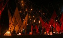
One of the groups came up with an idea of welcoming the alumni with large-scale light installation named ‘A Corridor of Happiness’ (আনন্দ উঠান). Five hyperbolic tower structures were composed in a staggering order to make the alleyways in between signifying an illuminating corridor for the alumni. The free-standing structures were completely made out of full-length bamboo culms tied in a diagrid pattern creating enough structural stiffness to withstand certain vertical loads.
This project tried to set an ambiance and a mood of celebration through the use of diagonal elements, subtle interiority, and translucency of colored fabrics. Some custom- made seatings were made of metal frame and weaving ropes to let the visitors sit and stay in the interior space for a while and enjoy the ambiance. Students and construction facilitators worked hand in hand to resolve the construction challenges in the site through a trial and error method. This installation marked the grand inauguration of the biggest celebration of CUET.
The idea was to capture an in-between space that would complement the scenic beauty of the site and engage the visitor with a scroll of memory. The airy and open to sky exhibition connected the pre-existing seating on the lakeshore with undulating bamboo screen creating a transitional space between nature and nostalgia. The intertwined relationship of nature and campus life took a form of celebration through the sensitive use of light, colors, materials, and exhibits.
The main program of convocation and the cultural function of the event were held in the central field. To let the alumni indulge in enjoyable recollection of past events, a multi-level platform was installed with a luminous backdrop under a large Koroi Tree by the third student group. This project engaged the alumni with a group of gathering while taking tea and taking group photos. The concept was the same as a Tong stall where people sit for a while, take a cup of tea, and gossip. The airy, open grid construction also provides a visual lightness to the structure that melds well with the surrounding landscape. This represents a modest expression of a grant gathering of the CUET alumni.
The Tejgaon Industrial Area was first established as an ‘industrial District’ in the Masterplan for Dacca drawn up in 1959 by the Dhaka Improvement Trust. In 1968 DIT planned the district as a Light Industrial Area and divided it into large plots appropriate for industrial development. Of course, over time land division and acquisition have resulted in much smaller and larger plots as well. The development of Tejgaon as an industrial zone went on unabated post-independence with an increase in residential and commercial activities during the 90’s. With the development of the Economic Zones in peripheral areas of Dhaka many Industries started shifting to the new areas during this time. Though this period shows a significant shift in land use patterns, to date the majority of land use is still allocated for Industrial use with Commercial, Residential and Institutional uses also mediating in between. The nature of change is consistent with the rapid financial growth during the start of the new millennium that spurred the random development of a commercial belt along Gulshan Avenue. That coupled with the development of the Gulshan-Tejgaon link road has brought a new boost in commercial growth especially in the north fringe of the area. The steady loss of importance as an Industrial zone has thus been compensated for by a new emerging need for a mixed use zone to support the concentration of commercial activities that spill over from Gulshan Avenue up to Gulshan-Tajgaon Link road.
The Detailed Area Plan for Dhaka recognizes the ensuing change in the character of the Tejgaon Industrial Area. According to DAP the TIA is to develop as a mixed-use zone. However, there is no clear indication of the nature of this development. Recent trends in creating high rise buildings along the northern fringe are indicative of high-density commercial developments. If this trend continues the area will not only become subject to over-densification but also create severe pressure on the environment and ecology of the area. The objective of this studio is to develop create a vision for the future of TIA that permits high density mixed-use while maintaining sustainable, people-oriented and environment-friendly principles for urban design. The students are encouraged to develop independent ideas that are coherent with future changes and formulate strategic guidelines for the development of the area as such.
OBJECTIVES:
To develop guidelines & regulations for overall planning- building heights, road widths, circulation system, drainage, blue-green system and land use.
To determine edge conditions.
To visualize an active public ground for the area that serves both the locality and the city
We have presented three different approaches to re-envisioning the area from three different student groups for the audience to have a comparative opinion.
Tejgaon Industrial Area Thana (Dhaka Metropolitan) is bounded by Gulshan Thana on the north, Ramna Thana on the south, Gulshan, Rampura and Ramna Thana’s on the east, Tejgaon and Cantonment on the west.
Historically, the area has been a center of industrial activity in the city. Numerous plants and factories are in Tejgaon, in such diverse industries as garments, food processing, metal works, pharmaceuticals, etc. Tejgaon became the major attraction for the immense industrial activity to meet the ever increasing demand of growing population and found its location in the core of the city from the peripheral location.
According to the Detailed Area Plan (DAP), journalized in 2010, one of the major hindrances behind the improvements or expansion of Tejgaon Industrial Area is constantly changing land use of this city core. The DAP suggests that this industrial area should be relocated outside the boundary of Group-C area of the Detailed Area Plan (DAP). The government of People’s Republic of Bangladesh has recently decided to turn the entire Tejgaon Industrial Area along with its major roads into a commercial as well as residential district through a comprehensive master plan. Upon analysis of the whole Tejgaon Industrial Area, we were able to identify a number of problems in the selected area.
To revive the lack of urban activity, it was thought of converting the industrial zone into a mixed-use zone. So the idea of introducing independent neighbourhoods was strategized to keep the area active 24/7. However, if the whole area is converted into one single neighbourhood, a number of areas would still remain dead after specific hours. To eliminate this completely, it was thought to split the area into several segments, each segment becoming a separate independent neighbourhood that merges with the other through a common public facility. The neighbourhoods are divided according to the walking radius so that every facility is available within a walking distance. A person can walk a distance of 500m in 5 minutes so the neighbourhoods are divided according to the radius.
Each neighborhood has a mix of all the functions, like, commercial, residential, mixed-use, institutional, mosque, health, and open space, service according to different percentages so that each zone has a priority of a single function. Although each neighborhood has a separate focus, the goal is to create a balance of all the facilities in each neighborhood, and that every neighborhood becomes independent. However, although independent, each neighborhood depends on or connects to another for specific public functions. For instance, people from other neighborhoods come to Neighborhood 02 for the giant shopping mall, and to Neighborhood 04 for universities. So that public interaction between the neighborhoods is active.
With the elimination of the industries, the proposed land use tries to balance the functions among the seven neighbourhoods. Along with the functions, a more defined plot system and road network have also been proposed. The proposed land use also adds public green spaces in the neighbourhoods.
The new master plan proposal tries to conserve most of the existing infrastructure of the area. Since the industries are to be moved out, there are scopes for new functions to be introduced in the spaces that are holding industries at the moment. This favors the balancing of functions in the neighbourhoods the area is to be divided into. Rather than completely demolishing and reconstructing, the proposed master plan attempts to create a public realm for the future by renovation and enhancement of the existing urban fabric.
The master plan proposes an enhancement of road network throughout the site with minimum alteration of the existing urban fabric, improving the road connectivity with the surroundings, however, restricting through roads in the neighbourhoods, promoting walkability; also converting a number of vehicle-free roads within the neighborhoods. However, this has been done ensuring efficient vehicular accessibility to all the plots from the other sides. Moreover, as the required facilities are placed in a walking distance, the need for taking a vehicle is brought down. Public recreational spaces, educational institutes, super shops are made available to every neighbourhood and also ensuring safer roads with proper crossing, bicycle lanes, wide footpaths and buffer spaces.
Police station and fire service at the central block ensure proper connectivity with all the neighbourhoods. Putting lumps of green wherever possible, a network of green is established following the road network, which connects the larger green areas, like parks or public squares.
The seven separate neighborhoods have their own distinct characteristics, however, all of them are independent, having a mix of activities that keep them active throughout the day and night. As per the design concept, the strategies have been applied to create self-sufficient neighborhoods, improving public accessibility while also ensuring the safety and necessities of the residents.
Taking the “Neighborhood 02” into account, we can take an in-depth look at how the strategies have been applied.
The existing land use of this area expresses the dominance of commercial activities, however, with the elimination of the industries, there grows scope for introducing new facilities primarily to satisfy the needs of the concept, creating an independent neighborhood.
A number of tertiary roads have been turned into complete pedestrian roads, so that they can host various public activities and moreover, people can walk throughout without vehicular disturbance. This does not, however, completely omit the access of vehicles inside. A few one-way vehicular roads have been introduced, ensuring vehicular access to every plot.
Being a commercial based area, and along with residences and educational institutes, the neighborhood demanded public spaces. With various people coming in throughout the day, public spaces, a park, market place and outdoor sitting areas have been introduced.
A community park at the heart of the neighborhood that links access from all the connected roads and allows people from all sides. The park, itself, contains a number of programs for the visitors: a playground, indoor games facilities, gymnasium, tea/coffee stall, shop, and an amphitheater. The park is designed to host both the residents and other people coming here for school, college, commercial purposes or for the shopping mall. The park can also host cultural festivals throughout the year.
Student Name: S.M. Mahmudul Haque | Suhrath Tasnim Rahman| Rahat Hasan| Farhana Abdur Rashid| Abu Rayhan
Zone Detailing by:
Suhrath Tasnim Rahman| S.M. Mahmudul Haque | Rahat Hasan
The inventory of land use within the study area contains details on the land parcel that characteristics as plot size, plot ownership and market value. Detailed information on existing structures including type of structure, ground coverage, number of stories, use of buildings, density of plots was also included through physical survey.
The analysis shows that a substantial proportion of existing land use has an increased plot density consisting mainly of industrial land use. Further depth categorization of land usage within each of the area’s main land uses as commercial, industrial, residential, institutional shows three main uses of Industrial land that dominates the total industrial establishment within the study area, namely chemical, within the study area, pharmaceutical industry, clothing industry. While the residential land uses inside the region is found nearby the Hatirjheel lake along Hatirjheel-Gulshan interface road with a wall built. These residential uses grew critically as unplanned settlements pushed the very lack of quality of life. Not just this, but the plots allocated with settlements are crowded in by a barrier along the interface road blocking the visual connection of the lakeside. Furthermore, the existing pattern of the landuse consisting of commercial and residential lifestyle has no connection and is completely detached. According to Bangladesh Planning Research Conference (BPRC), a study approves that the absence of proposer land use control, the growing trend in commercial development may result in such a development that may deteriorate and is more unlikely to collapse the entire cityscape. In addition, the study also mentions of Detailed Area Plan (DAP) who suggests “an additional proposition that if possible then this industrial area should be relocated outside the boundary of Group-C area of the Detailed Area Plan (DAP) and the area should be kept as an extension of Kawran Bazar for future commercial cum office zone or a large scale open space cum recreation zone”.
However, while surveying the area, it occurred that despite industrial zones located, the roads are much wider than necessary meaning less traffic now and later which is a positive remark as we introduce the commercial development that will play as a significant part in defining the economic growth trend of the region with no road distress. When working on the establishments of the area, our goal was to turn the place into an iconic zone that is larger and doesn’t lack people as it does now. Removing the wall blocking the lakeside view will not just increase its visibility but also the market price of land in Tejgaon industrial area tentatively.
Tejgaon will meet the growing commercial space demand in the capital as the transformation of Tejgaon Industrial Area is necessary. The master plan will contain, integrate public spaces and other human necessities, so that people can profit socially as well as economically. Strategic planning was crucial as the existing and proposed trends were to be merged to maintain the region’s timeless essence.
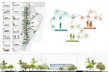
Firstly, after a thorough study, the analysis reveals different categories associated with land use. Further detail categorization of land use within each of the area ‘s major land uses as Commercial, Residential, and Government/Institutional Organization. Secondly, the existing land characteristics and structure within the study area indicates some of the known nodes and its connectivity that is in a haphazard manner. By shedding light on one formal category of image elements to which we can split the region conveniently, more spaces were identified alongside and proposed an efficient connectivity that doesn’t disrupt the current flow. A legible spine is produced by introducing three major focal points that articulate the flow and connect the major land uses that were located. Finally with the spine as the center of attention in urban planning, our priority was set focused to bring the lively into the area through the recollected nodes by the optimum use of public spaces. These were further divided into classifications of its value to the surrounding such as, Type A (Environmental Value), Type B (Social Value) & Type C (Economical Value).
Type A class serves nature in a couple of ways by reducing pollution (air, noise, water), Increasing ecological diversity, and reducing energy consumption i.e. parks, community gardens and cemeteries. While Type B class treats the social users, improved quality of life, increased mental and physical vitality i.e. walking, sports club and cultural amenities. Last is Type C class where parks, squares, gardens and other public spaces are becoming an essential business and marketing tool, higher property prices i.e. bazaar and retail markets.
Initially when the Public Works Department (PWD) prepared a master plan during the year of 1950, the structure supported the emerging of Industrial use and was voted in the year 1959. Soon after ten years, the Department for International Trade (DIT) planned the are as a light industrial zone but couple of years later the area went through a massive unplanned development, According to the Dhaka Metropolitan Development Plan (DMDP), the non industrial land uses (commercial, office, etc) have increased taking a great toll on the industrial uses gradually. In the year of 2014, the government has decided to turn the area into a commercial cum residential district and hence provides the basis for evaluating the transition in land use in this area between 2005 and 2015.
As stated in DMDP, being close to Dhaka city’s core Tejgaon attracts numerous business activities in this area. Meanwhile during the study of this area, the critical analysis shows that most commercial land use buildings within the district are high-rise building categories and so we encouraged the expansion of commercial along with mixed-uses thus growing trend in commercial activity. However for a pedestrian activity with no modes of transportation, there was no flexibility in the region as the only footpaths denoted were simply near the major road adjacent to the highway, and mostly left deconstructed. The disconnection of the internal road linking the district was particularly poor whilst the lack of parking places didn’t go unnoticed.
A hierarchically interlocked transport system and pedestrian routes of varying degrees and continuity is maintained in the proposed plan. The roads are further divided into three categories, the primary drives functions as the major road (i.e. car, cus, trucks, auto rickshaw), secondary drives will mainly transport vehicles of a average scale (i.e. cars, auto cngs, cycle and rickshaws) while the tertiary drives will have auto rickshaw. and rickshaw movements. Serving drives in a given policy will increase its efficiency and connection as well as remove any road encroachments that have been identified during the study in the area. Along the focus points of the spine, three bridges are proposed for a smoother fluidity in movement causing no distress to the vehicular routes.
Correspondingly in the earlier statements of growth trend, each of the 430 plots exists a large range in plot size in the study area, ranging from 0.5 katha to 200 katha. Keeping the suggestion of DAP in mind, both building and land use map was carefully adjusted through the division of plots in major sectors. While commercial is proposed with 20-40 katha, residentials is confined within 0.5-15 katha. PWD recommended shifting the CSD, the BFDC and the truck from the food department to a convenient location and using a portion of the liberated field for multi-use purposes and selling the remaining plots so that the funds could be used to rehabilitate government institutions.
The plan was carefully drafted and then continued with the assessment of project feasibility, the creation of a database of public and private establishments in the region and so on. After a strong green spine that connects most of the site, includes an open public space in the heart that has a variety of public functions all supported by pedestrians continuing a strong vertical flow. The spine classified into different public spaces has activities that are safe i.e. Library, Foodcourt, bazaar, sports club etc. People of all age and different users are welcome to come and influence a vibrant public hub. In the near future, recreation and leisure activities in urban parks such as walking , running, cycling and picnicking will increase due to higher living standards and people looking for a healthier lifestyle.
The proposed master plan will not just increase nodes of the district but also encourage the public hubs as landmarks of the area, fulfilling the goal of bringing the city to life and fabricating a better lifestyle.
As an important part of the cultural regeneration, as factors such as mixed-use buildings, environmental conservation projects and, in particular, public art contribute to the creation and growth of the area ‘s culture. Being at almost the core of the district, our proposed plan placed a cultural hub for both commercial and residential zones to serve people of various purposes.
The cultural hub consists of classrooms, events, and etc. It serves as an extracurricular activity for the youth through the interactive learning center by supporting arts and preserving heritage. Surrounded by an performance stage and various seating spaces, the public movements are well encouraged.
The circulation is very fluid through the plaza, allowing other interactive activities to take place, such as small retail shops, outdoor cafe’s, event plaza and etc ensuring a safe activeness at any time of the day. The connections established in the design continues through defined pedestrians. It creates a well inviting environment for the family-friendly neighbourhood and a communal gathering connecting from the public realm.
The concept of our design is to bring the public realm into Tejgaon I/A by creating a lifestyle system that we call live, study, and work. We have proposed to divide three zones based on commercial, institutional, and residential areas. Another way of reviving the urban area is by creating age group variations. By emphasizing more on young generations, we have proposed to create a diversity around the area which makes the city alive. By “young” we mean the millennials. Millennials are those who are members of the generation born between 1981 and 1996. Based on the year range of birth, they are divided into three categories: GenX, GenY, GenZ. GenZ is considered the youngest one. We have named our project based on that.
In the late ’50s, Tejgaon was announced to be an industrial area but since then it did not develop as expected. Rather it was always an industry dominated mixed-use area in the heart of the capital. So recently the government announced to move the industries for the sake of the environment of the city.
Based on the concept, we have proposed to create a common platform for GenZ, and other people who are part of the area. To ensure that, we have proposed to increase institutes, offices, residences. Our area is divided into three zones based on that proposal. We have also proposed to connect them using various mixed-use functions, public spaces to establish the public realm which is lacking here.
We have proposed a commercial belt, institutional belt, and residential belt for distinguishing. As our main focus is to bring in more youngsters here so we have proposed an institutional belt where students from different interests will be able to build a knowledge-sharing community. We have proposed a residential zone which is divided into 3 parts, the first one is alongside to Hatirjheel, the second one is a residence-based mixed area with a line of shops and facilities which will support both study and live. Finally the third is dormitory to accommodate the students. As the government has announced to move the industries from Tejgaon, new windows open here for business. We designated a zone for our work part where the land use is mixed with Industrial and commercial. By placing a business district here, an inter-exchanging community will grow between the corporates and students. We, at the same time, have proposed to connect the functions by adding green spaces, market places, public places. We ensure the proper distribution of building use to develop the public realm here.
One of the goals of our design is to introduce the public realm around the area. We have proposed to create interactive layers of public activity that connects the ground floors of different buildings. We have also proposed to increase night-life activities, to attract people into public spaces so that the area is no longer dead. The plots we have chosen to achieve that goal are commercial and institutional. For commercial plots, we have proposed to create public spaces linearly in the middle of each plot. Those spaces will transform into a public gathering environment. Office workers will find the place as a refreshing environment during their breaks from work and after offices break. The residents and students will be drawn to this place because of its green and versatile nature.
For the institute, we have proposed to merged two plots and created a mass that connects the two plots via bridges. The open gallery in front of the institute connects all groups of people. Keeping in mind the privacy of the university, we have proposed to define the gallery in such that everyone uses it without disrupting the security of the institute. Thus we connect the three major users [commercial user, residential user, institutional user] using the spaces.
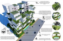
“This award of citation for well thought out plan that the participants are connected green building’s elements to the exterior environments in a very simple almost minimalist way yet smart enough to define clearly on the importance of Green Buildings’ roles in against epidemic such as Covid-19. It shows a powerful way to restraint and simplicity putting the emphasis on the quality of spaces over fussy architectural detailing to overcome the pandemic.”
Concept
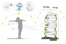
A 21st Century Green Building can be defined as a building with minimal consumption of resources, has minimum emission and enable to operate with renewable energy sources. Green Building design principles adopt a healthy living condition in a build environment which substantially benefit human from improving mental and physical health. A Green Building would tremendously increase the human immune system due to the strategic passive design, which would be an effective approach to fight COVID 19 pandemic.
On the other hand, Green Building produces renewable energy, minimizes consumption both for energy and water and recycles resources, like, rainwater, gray water, would benefit a community financially by diminishing resource demand during the economic recession.
While benefitting from all optimum use of resources, Green Buildings also allow inhabitants to grow own food within their urban sprawl, which would allow people to stay home for long period without having difficulties of procuring food and vegetable.
COVID 19 patients often advised staying home in an isolated condition where the recovery paved up by improving a patient’s immune system. Along with other prescribed activities, space itself plays a substantially important role to boost up his immune system. Cross ventilation decontaminate the space, sunlight provides Vitamin D and ample of Natural light boost up mental health. Similarly, for a non-infected person, the indoor environmental quality would be a great addition to improve self immune and mental health which would enable them to fight COVID 19 Pandemic.
Green Building minimizes resource consumption like energy and water. On the other hand, Green Building produces energy from renewable sources, for example, Photovoltaic Energy, Wind Energy which further keeps the demand to an optimum level. During COVID 19 pandemic many countries have gone through economic and resources constraint, where Green Building would be an effective solution to face the challenge of limited resources.
Secondly, Green Building design strategies emphasize rainwater recycling and greywater recycling. During COVID 19 pandemic water usages become substantially higher due to the prescribed personal and community hygiene. This extended demand for water can be balanced with the recycled water without creating extra demand for water from external supplies.
The most effective strategy adopted by the world in order to fight COVID 19 is Home Quarantine for a long period. It has become a great difficulty to procure fresh food and vegetable regularly from the outside in the lockdown situation.
Green Buildings often promote urban agriculture, vertical gardening and community farming. During the Quarantined period, Green Buildings could ensure the supply for fresh vegetable and fruits for the occupants, and allow them to stay home and ensure own safety.
To sum up, in the sudden outbreak of COVID 19, humankind still remains in grey. Until the successful invention of the vaccine, the only known method in practice is social distancing and boosting up self immune in order to fight the virus. It is widely advised to stay home and carry out certain activities to achieve the highest health protection.
While staying home for a long period, it is conclusively seen that consumption of resources become higher than ever. Whereas, this crisis situation demands to descend of resource uses due to the economic recession. Green Building as a first concern minimizes the consumption of resources which would be a great contribution in the fight against the pandemic.
In addition, Green Building maximize climatic efficiency and allow nature to interact in an indoor environment. Indoor Environmental Quality in a Green Building is highly beneficial for improving self immune and mental health, which is further a known strategy to fight COVID 19.
About the Author:
Architect Shafique Rahman (MIAB) is currently affiliated as Assistant Professor at Ahsanullah University of Science and Technology (AUST). He is the principal architect of the consulting firm called Trikon Architects.
As we’ve switched to the online class, each day beside studio projects I used to discuss with my students a lot about the pandemic situation. I was also glad that all the students were very aware of the situation. From this informal discussion, I realized that they felt to do something from their positions. Therefore we decided to perform a brainstorming session on future living and formulate schematic design ideas. This studio assignment was therefore about the future of our built environment, both urban and rural, while keeping in mind the factors of infectious disease.
Though it is too early to predict the future living, as more research yet to be done on the relationship between built environment design and the case of infectious disease, the studio felt the urgency to start the process within its limited scope. The process involved reviewing emerging literature, conducting a structured questionnaire survey using digital media, and finally expressing the design idea through freehand sketches or computer-generated 3d models. An informal discussion was also conducted on ‘urban farming’ at the beginning of the project, as due to COVID-19 the need for ‘urban farming’ is felt more than ever.
Findings at the City:
Fear of losing the job, reduced income, lack of breathing space in the housing environment with limited or no facility for kids, teenagers and elderly people, restricted rooftop access, growing anxiety and mental health risks due to social isolation, observed changes in kid’s behavior, no housemaid for domestic help, etc. are the key findings at the city. Some positive things are- better bonding among family members, time for a hobby, common washing facility on the ground floor, etc.
The solutions for urban environment have its focus on apartment housing which include measures like sanitization, walking facilities, green and open space for different activities, multifunctional spaces, advanced technology for less touch activities, passive ventilation, the scope of urban farming, green measures for water and electricity production, water filtration plant, home office concept, etc.
Designed by Faria Tabassum
Terraced housing | FariaTabassum
The lockdown situation has heavily impacted the social life and mental well being of the apartment dwellers. Every unit of the proposed housing has spacious balconies overlooking the green terraces to maintain the social connection while keeping physical distance.
Designed by Mst Mahmuda Akter
Biophilic urban living | Mst Mahmuda Akter
The design idea focuses on our intimate spaces: the quality and comfort of our homes. The proposal calls for housing with integrated green and garden systems with rooftop and terraces for plants and edible produce, improved natural light and ventilation, minimal and wholesome indoor environments, etc.
Designed by Matrin Mozammel
Touchless technology | Matrin Mozammel
Community transmission within the apartment complex can be kept under control by reducing the touchable surface in the domestic environment. The proposal advocates the use of automated entrance, thermal scanner, voice-controlled elevators, etc in the transitional and shared spaces.
Findings at the village:
The lockdown situation has threatened the rural household income severely. Market centric businesses are suffering the most. Farmers are unable to cut crops due to labor shortage, eventually resulting in food crisis in the market. Lack of storage facilities, lack of awareness about social distance, poor internet connectivity and fluctuating power supply are the key issues identified. It’s difficult to maintain physical distance as the village houses are closely spaced in a community. The villagers feel like they won’t survive if the situation continues, they’ve started taking the loan. Those who produce vegetables or poultry are surviving somehow.
Findings from interviews | Interviewed by Yeasmin Akter
The solutions for the rural areas, with a primary focus on the homestead, include strategies like provision of available spaces for agriculture and food processing etc, separate yet close to each other, alternate way of income where possible, large storage facilities for crisis moment, Baithok khana/ Kachari ghar as an isolation room, strategically placed tube-well, etc.
Designed by Arafat Amena
Arafat Amena
৭০ শতাংশ গ্রামের মানুষই কৃষিনির্ভর । সম্প্রতি বৈশ্বিক মহামারীর জন্য গ্রামের মানুষ আর্থিক সমস্যাসহ নানা প্রকার সমস্যার মুখোমুখি হচ্ছেন । শুধু তাই নয় অনেকেই স্বাস্থবিধি মেনে না চলায় অসুস্থ হয়ে পরছেন । অনেকেই নিজের খাবার নিজে উৎপাদন করতে না পারায় খাদ্যের সমস্যায় পরছেন । এই নকশার উদ্দেশ্য ছিল এই সকল মানুষদের এই মহামারিকালীণ সময়ে নিজ বাসায় থেকে কি করে খাদ্য উৎপাদন করা এবং সামাজিক দূরত্ব বজায় রেখে তাদের দৈনন্দিন সকল কাজ করা যায় তার ব্যাবস্থা করা।
About the Author:
Architect Sheikh Md. Rezwan is a senior lecturer and studio guide of ARCH 402, Department of Architecture, Daffodil International University.
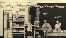
This lockdown managed to provide my parents some free time as none of them had to go to the office; they spent the time either by watching TV while having a cup of tea or just playing their favorite board games. They usually don’t get any time at all for themselves so it was a relief watching them getting out of the loop of the crazy busy schedule they were stuck in.
Well, for me it was a great deal of struggle to get used to this unusual situation. Added anxiety together with sleeping irregularities ultimately leading to insomnia made it really hard to get any of my works done. It is all just chaos inside the head trying to choose between whether to try and catch a breath or just keep being busy to forget the fear of unknown.
Saba Islam is an undergraduate student in the Dept. of Architecture, Bangladesh University of Engineering and Technology (BUET). For the past couple of years, she has been continuously practicing to vent her thoughts and share memories through drawings. In this difficult time, these have been helping her to manipulate herself not to be stressed.
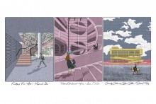
Color is an integral element of our world, not just in the natural environment but also in the man-made architectural environment. Color always played a role in the human evolutionary process. The environment and its colors are perceived, and the brain processes and judges what it perceives on an objective and subjective basis. Psychological influence, communication, information, and effects on the psyche are aspects of our perceptual judgment processes. Hence, the goals of color design in an architectural space are not relegated to decoration alone.
We’re living in a world full of color and even though we may not be as well-equipped to distinguish between all the subtle nuances we definitely enjoy playing to them and experimenting. Color is everywhere and without it, nothing would be the same, not even the buildings that you walk by every day. Colors help in developing perspective and understanding the nature of a building. Therapeutically, architecture and color go hand in hand. It is an important and needed approach to accept architecture, just for the fact that our daily lives are affected by all the places and their way of existence, it becomes necessary that the use of colors in appropriate and subtle ways is understood and implemented. It enhances the ability to intercept better with the surroundings and triggers our mood. Every space can be distinguished with its approach towards human and non-human interaction. Architecture plays an important role in promoting it, and color in architecture helps understand that interaction better.
Asad Hossen is an architect, urbanist and graphic designer, currently working as an urban designer in a Shenzhen based firm in China. He passed his B.Arch from BRAC University, Bangladesh,and completed his masters in Urban Design from University of Hong Kong. From the beginning of his study in architecture, he has always been fascinated by architectural drawings and illustrations; constantly looking for inspirations from other artists. He tries to communicate as much as possible with his drawings. Drawings and illustrations are always therapeutic to him.